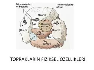

topraklarin siniflandirilmasi
E N D
Presentation Transcript
1. Topraklarin Siniflandirilmasi TOPRAK BILGISI DERSI
ZTO203
Do�.Dr. Hasan Sabri �zt�rk
hozturk@agri.ankara.edu.tr
3. Eski Amerikan Toprak siniflandirma Sistemi Sistemin Katogarileri
Ordolar
Zonal ( iklim ve bitki �rt�s�)
Intrazonal (Topografya ve ve ana materyal)
Azonal (Zaman yetersizligi, ana kaya, erozyon, birikme)
Alt Ordolar
B�y�k toprak gruplari
Familyalar ( horizon renk, kalinlik ve �zellikleri ile ana materyal)
Seriler ( ayirici toprak �zellikleri, dizilis, benzer ana materyal)
Tipler ( �st toprak tekst�r�)
4. Zonal Toprak Ordosu Iklim
Genis yer kaplarlar
Ana materyalin etkisi azdir
5. Zonal Toprak Ordosu 1. Soguk B�lge Topraklari
Tundra topraklari
2. Soguk ve Yagisli B�lge Topraklari
Podzollasma
3.Podzol ve Podzolik Topraklar
4. Sicak ve Yagisli B�lge topraklari
Latasoller
5.Iliman yari kurak B�lge Topraklari
Kire�li topraklar, �ernozyemler, Kire�siz Kahverengi topraklar, Kestanrenkli ve Kahverenkli topraklar, Akdeniz Kirmizi topraklari
6. Sicak Kuru B�lge Topraklari
��l Topraklari (Gri ��l, tipik ��l, Kirmizi ��l)
6. Podzollasma Podzol= K�l alti
Sicaklik
Yagis ve
Bitki �rt�s�
7. Latasol Olusumu Bol yagis
Y�ksek sicaklik
Ca, Mg, K, Na yikanmasi ( H ile yer degistirme)
pH=7
SiO2 ��z�nerek yikanmasi, Fe, Al ve Mn konsatrasyonunun altmasi
8. Kire�lesme Kalsiyum birikmesi
Yetersiz yagis ve sonu�ta Ca ve diger katyonlarin profilin alt kisimlarinda birikmesi
9. INTERZONAL TOPRAKLAR ORDOSU Hidromorfik topraklar
Halomorfik topraklar
Tuzlu topraklar ( EC> 4 dS m-1 , %Na < 15, pH<8,5)
Tuzlu alkali topraklar (EC> 4 dS m-1, %Na > 15, pH �8,5)
Alkali topraklar (EC< 4 dS m-1 , %Na > 15, pH>8,5
Kalsimorfik topraklar ( Kire�
etkisinde kalmis)
Kahverengi orman topraklari
Vertisoller
10. Vertisoller T�m horizonlari killidir
Yikanma ve birikme horizonlari yoktur
Blok str�kt�r basattir
Montrorillonit tipi (2:1) sisebilen kil hakimdir
Siyah, koyu gri renklidir
Gen� topraklardir
11. AZONAL TOPRAKLAR ORDOSU Tasli olgunlasmamis topraklar (lithosol)
Tassiz olgunlasmamis topraklar (Regasol)
Silisli Kayalar �zerinde olusan olgunlasmamis topraklar (Ranker)
Al�viyal topraklar
12. YENI AMERIKAN TOPRAK SINIFLANDIRMA SISITEMIToprak Taksonomisi Daha fazla bilgi birikim �r�n�
Daha �ok katogori ( 12 ordo, 54 alt ordo, 250 b�y�k toprak grubu)
Ayirici karakteristikler arazi veya labaratuvarda �l��lebilir veya g�r�lebilir �zelliklere dayanmaktadir.
Toprak profili yerine Pedon
Ordo adlari �sol�ile biter
13. ORDOLAR 1. Alfisol
2. Andisol
3. Aridisol
4. Entisol
5. Gelisol
6. Histosol
14. ALFISOLLER Yari kurak ile humid alanlar arasinda olusur.
Kilce zengin y�zey horizonu olan y�ksek verimli topraklardir.
"Alf� Al�minyum (Al) ve demiri (Fe) simgeler.
Alfisols orta derecede yikanmistir.
Bazla doygunluk orani en az %35 dir
(Kalsiyum, Magnezyum, and Potasyumca zengin)
15. ANDISOLLER Volkanik k�llerden olusmustur ve y�ksek oranda cam ve amorf kolloidal materyalden i�erir,
Gen� ve �ok verimli topraklardir
Andisollar buz altinda kalan topraklarin disindaki topraklarin %1�ini kaplar. En �ok Sili, Ekvador, Kolombiya, Meksika, ABD�nin kuzeybatisi, Japonya, Java, Yeni Zellanda , Italya,
Irlanda, Havai de bulunur.
SUBORDERLAR
Aquands � taban suyu seviyesi yilin �ogunda y�zeye yakin
Gelands � �ok soguk ilkimler, (ort. yillik sicaklik <0�C).
Cryands - Soguk iklimler,
Torrands � �ok kurak iklimler,
Ustands - Yari kurak ve yari nemli iklimler
Udands � Nemli iklimler
Xerands � Iliman iklimler (Sicak yazlar ve nemli kislar)
Vitrands � Gen� Andisols, kaba b�nyeli ve cam orani y�ksek.
16. ARIDISOLLER ��l Topraklari
Latince aridus, �kurak� �tan gelir.
Kurak ve yari kurak iklimlerde olusur.
Aridisoller d�nya y�zeyinin 1/3 ��n� kaplayan ��llerde olusur,
D�s�k organik madde i�erir,
En �enmli �zelligi d�s�k toprak nemidir. Yikanma sinirlidir.
Y�zey alti horizonlarinda silikat killeri, sodyum, kalsiyum karbonat, jips veya ��z�nebilir tuzlar bulunur.
Y�zey alti horizonlari karbonatlar, jips ve silikalarca �imentolanmistir. Y�zeyde tuzlanma olusabilir.
17. ENTISOLLER A horizonu disinda herhangi bir profil gelisimi yoktur,
Yeni tasinmis ana materyal veya olusum hizinin erozyon veya birikim hizindan yavas oldugu alanlarda olusur
Tanimlayici horizonlari yoktur.
En yaygin ikinci toprak ordosudur. Entisoller buz altinda kalan topraklarin disindaki topraklarin %16 �sini kaplar
18. GELISOLLER �ok soguk iklimlerde olusur, toprak y�zeyinden itibaren ilk 2 m si i�erisinde de kalici buzlanma vardir
"Gelisol� latincede �buzlanmaya dogru� anlamina gelen gelare den t�remistir.
D�n�s�ml� donma-��z�lme olayi en karakteristik �zelligidir.
Yapisal olarak B horizonu yoktur, fakat A horizonu vardir.
Y�zeyde ince bir mineral tabakanin �zerinde organik madde biriktigi i�in siyah veya koyu kahve renklidir.
Kimyasal olarak y�ksek verimli degildir. Donmus tabakanin �zerindeki besin maddeleri (�zellikle Ca ve K) yikanmistir.
En �ok Sibirya, Alaska ve Kanada�da daha sonra Sili, Arjantin, Tibet, Kuzey Iskandinavya, Antartika�da bulunur
19. HISTOSOLLER Organik maddeden olusmus topraklardir . �st 80 cm de 40 cm
veya daha fazla organik toprak materyali vardir. Karbon orani
% 12 ile 18dir.
Y�ksek OM, k�t� drenaj, asidik, d�s�k bitki besin maddesi
Histosoller degisik �lkelerce farli isimlendirilirler (peat, muck, organosoller).
Histosoller k�t� drenaj kosulllarinda (anaeorbik) olustugundan
organik atiklarin ayrisma hizi birikme hizindan d�s�kt�r.
Yaygin olarak Kanada, Iskandinavya, Bati Sibirya, Sumatra, Borneo, Yeni Gine�de bulunur. Avrupa�nin kuzeyinde Rusya�nin dogusunda, Florida�da yer yer bulunur.
D�s�k verimlilik ve drenaj sorunu nedeniyle tarima uygun degildir. Gen� buzul �aginda olusmus histosoller drene edilince �ok verimlidirler.
20. INCEPTISOLLER Ana materyalin hizli bir sekilde ayrismasiyla olusur
Zayif horizon olusumu
Kil, Fe, Al ve OM birikimi yoktur
Alt Ordolari:
Anthrepts
Aquepts
Cryepts
Udepts
Ustepts
Xerepts
21. MOLLISOLLER Yari kurak ile yari nemli b�lgelerde olusur.
�ogunlukla Kuzey Amerika, G�ney Amerika (Arjantin,ve Brezilya), Mogolistan ve Rusyanin Steplerinde bulunur.
Ana materyalleri bazla doygun, kire��e zengin kire� tasi, l�s ve r�zgarla tasinmis kumca zengindir .
A horizonlari y�ksek OM ve besin maddesi i�eren derindir (60-80 cm)
Molisoller buz altinda kalan topraklarin disindaki topraklarin % 7 �sini olusturur. D�nyanin en verimli topraklaridir.
22. OXISOLLER Tropikal yagmur ormanlarinda olusur ( Ekvatorun 15-25
derece kuzey ve g�neyi)
�nceleri bu topraklar laterit olarak siniflandirilirdi
T�m derinliklerinde en fazla %10 ayrismis mineral i�erir
KDK si d�s�kt�r.
Y�ksek derisimdeki Fe ve Al oksit ve hidroksitleri
nedeniyle daima kirmizi veya sarimsi renktedir
Kuvars ve kaolin ve az miktarda kil minerali ve OM i�erirler
Tropik yagmur ormanindaki yogun bitki �rt�s�n�n b�y�k miktarda besin maddesi saglayacagi d�s�n�lse de organik tabakadan ge�en yagmur sularinin asitlesmesi ile mineraller yikanir. Organik maddenin hizli ayrismasi ve ��z�nebilir besin maddelerinin yoklugu nedeniyle topraklar olduk�a verimsizdir.
Yaygin olarak G�ney Amerika, ve Afrikanin tropik alanlarinda bulunur.
23. SPODOSOLS (PODSOL) Rus�a �k�l alt� anlamina gelir.
Tarimsal olarak verimleri sinirlidir.
E horizonu 4-8 cm kalinliginda ve Fe ve Al oksitlerince ve humus�a fakirdir.
24. ULTISOLS Kirmizi killi toprak olarak bilinir
Toprak profilinin herhangi bir yerinde kalkerli materyal barindirmazlar, %10 dan az ayrisabilir mineral i�erir, %35 den az bazla doygunluga sahiptir
Kaolin kil mineralince zengin, sisme b�z�lme �zelligi olmayan topraklardir.
Yaygin olarak ABD�nin g�neyi ,Cin ,G�neydogu Asya�da bulunur,
25. VERTISOLLER Y�ksek miktarda sisebilen killeri (montmorillonit) i�eren, kurak mevsimlerde de derin �atlaklarin olustugu topraklar
Vertisols tipik olarak bazalt gibi temel kaya�larin �zerinde mevsimsel olarak nemli veya siddetli kurak ve sel altinda olusurlar
Vertisoller ekvatorun 50� N and 45� S arasinda bulunur. En �ok yaygin oldugu alanlar Australya, India, Sudan, Etiyopya, Kenya, Cad, G�ney Afrika, G�ney Amerika,Teksas ve Meksika, Nijerya, Dogu �in. T�rkiye�de ise Trakya
T�rkiyede Trakya b�lgesinde
Dogal bitki �rt�s�: mera, savana, �alilik
Sulama varsa pamuk, bugday, sorgum. En uygun bitki ise pirin�
27. FAO Toprak Siniflama SistemiWorld Reference Base for Soil Resources 30 referans toprak grubu;
Acrisols, Albeluvisols, Alisols, Andosols, Anthrosols, Arenosols, Calcisols, Cambisols, Chernozems, Cryosols, Durisols, Ferralsols, Fluvisols, Gleysols, Gypsisols, Histosols, Kastanozems, Leptosols, Lixisols, Luvisols, Nitisols, Phaeozems, Planosols, Plinthosols, Podzols, Regosols, Solonchaks, Solonetz, Umbrisols, and Vertisols.
28. FAO Alt Ordolar Acrisols
Andosols
Arenosols
Cambisols
Chernozems
Ferralsols
Fluvisols
Gleysols
Greyzems
Gypsisols
Histosols
Kastanozems
Lithosols
Luvisols
Nitosols
Phaeozems
Planosols
Podzols
Podzoluvisols
Rankers
Regosols
Rendzinas
Solonchaks
Solonetz
Vertisols
Yermosols
29. FAO Toprak Siniflama Sistemi 1.Organik topraklar
Histosoller
2. Insan etkisinde olusmus mineral topraklar
Andosoller (Volkan alanlarinda)
Arenosoller (Kumlu)
Vertisoller
3. Ana materyal etkisinde olusmus mineral topraklar
Fluvisoller (Alluvial)
Gleysoller
Leptosoller ve Regosoller ( Erozyona ugramis)
4. Zaman etkisinde olusmus mineral topraklar
Cambisoller
5. Yari Tropikal nemli iklimde olusmus mineral topraklar
Plinthosoller
Ferrasoller
Nitisoller
Acrisols,
Alisols,
Lixisols
30. FAO Toprak Siniflama Sistemi 6.Kurak yari-kurak iklimde olusmus mineral topraklar
Solonchaks
Solonetz
Gypsisoller
Calcisoller
8. Step iklimlerde olusmus mineral topraklar
Kastanozemler
Chernozemler
Phaeozemler
Greyzemler
9. Yari nemli karasal iklimde olusmus mineral topraklar
Luvisoller
Podzoluvisoller
Plansoller
Podzoller
32. Aridisoller �Kurak b�lgelerin a�ik renkli topraklari� ve �tuzlu ve alkali� topraklarin �ogunu i�ine alir.
Alt ordolar
Argidler
Argilik horizon (silikat killerinin biriktigi illuvial horizon)
Natrik horizon (Fazla miktarda Na i�eren horizon)
Orthidler
��z�nebilir tuz ve karbonat i�eren horizon
33. Oxisols are an order in USDA soil taxonomy, best known for their occurrence in tropical rain forest, 15-25 degrees north and south of the Equator. Some oxisols have been previously classified as laterite soils.
The main processes of soil formation of oxisols are weathering, humification and pedoturbation due to animals. These processes produce the characteristic soil profile. They are defined as soils containing at all depths no more than 10 percent weatherable minerals, and low cation exchange capacity. Oxisols are always a red or yellowish color, due to the high concentration of iron(III) and aluminium oxides and hydroxides. In addition they also contain quartz and kaolin, plus small amounts of other clay minerals and organic matter.
The word "oxisol" comes from "oxide" in reference to the dominance of oxide minerals such as bauxite. In the FAO soil classification, oxisols are known as ferralsols.
Scientists originally thought that the heavy vegetation of tropical rain forests would provide rich nutrients, but as rainfall passes through the litter on the forest floor the rain is acidified and leaches minerals from the above soil layers. This forces plants to get their nutrition from decaying litter as oxisols are quite infertile due to the lack of organic matter and the almost complete absence of soluble minerals leached by the wet and humid climate.
Present-day oxisols are found almost exclusively in tropical areas of South America and Africa, almost always on highly stable continental cratons. In Australia vast areas formerly covered in rainforest have become so dry that oxisols have formed a hard ironstone cover upon which only skeletal soils can form.
Fossil oxisols are known from the first appearance of free oxygen in the atmosphere about 2200 million years ago. In warm periods like the Mesozoic and Paleocene, oxisols extended to areas that now have quite cool climates, extending well into North America and Europe. It is believed oxisols became vegetated later than ultisols or alfisols, probably because vegetation took a long time to adapt to the infertility of oxisols.
Oxisols are often used for tropical crops such as cocoa and rubber. In some cases, rice is grown on them. Permanent cropping of oxisols in low-income areas is very difficult because of low cation exchange capacities and high phosphorus fixation on iron and aluminium oxides (ligand exchange mechanism; inner sphere complex with phosphate). However, many oxisols can be cultivated over a wide range of moisture conditions. On this account, oxisols are intensively exploited for agriculture in some regions which have enough wealth to support modern agricultural practices (including regular additions of lime and fertilizer). A recent example of exploitation by modern methods involves the growing of soybeans in Brazil.
Oxisols are divided into the following suborders:
Aquox - oxisols with a water table at or near the surface for much of the year
Perox - oxisols of continuously humid climates, where precipitation exceeds evapotranspiration in all months
Torrox - oxisols of arid climates. Because the present climate can never produce enough weathering to produce oxisols, torrox soils are always paleosols formed during periods of much wetter climates. They occur mainly in Southern Africa.
Ustox - oxisols of semiarid and subhumid climates
Udox - oxisols of humid climates
34. In soil science, Podsol (also spelled Podzol, or known as Spodosol) are the typical soils of coniferous, or Boreal forests. They are also the typical soils of eucalypt forests and heathlands in southern Australia. The name is Russian for "under ash" (???/pod=under, ????/zola=ash) and likely refers to the common experience of Russian peasants of plowing up an apparent under-layer of ash (leached or E horizon) during first plowing of a virgin soil of this type. These soils are found in areas that are wet and cold (for example in Northern Ontario or Russia) and also in warm areas such as Florida where sandy soils have fluctuating water tables (humic variant of the northern podzol or Humod). An example of a warm-climate podzol is the Myakka fine sand, state soil of Florida.
Most Spodosols are poor soils for agriculture. Some of them are sandy and excessively drained. Others have shallow rooting zones and poor drainage due to subsoil cementation. Well-drained loamy types can be very productive for crops if lime and fertilizer are used.
The E horizon, which is usually 4-8 cm thick, is low in Fe and Al oxides and humus. It is formed under moist, cool and acidic conditions, especially where the parent material, such as granite or sandstone, is rich in quartz. It is found under a layer of organic material in the process of decomposition, which is usually 5-10 cm thick. In the middle, there is often a thin layer of 0.5 to 1 cm. The bleached soil goes over into a red or redbrown horizon called rusty soil. The colour is strongest in the upper part, and change at a depth of 50 to 100 cm progressively to the part of the soil that is mainly not affected by processes; that is the parent material. The soil profiles are designated the letters A (topsoil), E (eluviated soil), B (subsoil) and C (parent material).
The main process in the formation of Spodosols is podzolisation. Podzolisation is a complex process (or number of sub-processes) in which organic material and soluble minerals (commonly iron and aluminium) are leached from the A and E horizons to the B horizon.
In podzols, translocation has meant the eluviation of clays, humic acids, iron, and other soluble constituents from the A and E horizons. These constituents may then accumulate to form a spodic illuvial horizon and in some cases a placic horizon or iron band. Podzolization occurs when severe leaching leaves the upper horizon virtually depleted of all soil constituents except quartz grains. Clay minerals in the A horizon decompose by reaction with humic acids and form soluble salts. The leached material from the A horizon is deposited in the B horizon as a humus-rich horizon band, a hard layer of sesquioxides or a combination of the two.
35. Ultisols (some varieties, such as those prevalent in the American South, colloquially known as "red clay soil") are an order in USDA soil taxonomy. They are defined as mineral soils which contain no calcareous material anywhere within the soil, have less than 10% weatherable minerals in the extreme top layer of soil, and have less the 35% base saturation throughout the soil.
In the FAO soil classification system, most Ultisols are known as Acrisols. Others are classed as Lixisols or Nitosols.
The word "Ultisol" is derived from "ultimate", because Ultisols were seen as the ultimate product of continuous weathering of minerals in a humid temperate climate without new soil formation via glaciation.
Ultisols vary in color from purplish-red, to a blindingly bright reddish-orange, to pale yellowish-orange and even some subdued yellowish-brown tones. They are typically quite acidic, often having a pH of less than 5. The red and yellow colors result from the accumulation of iron oxide (rust) which is highly insoluble in water. Major nutrients, such as calcium and potassium, are typically deficient in Ultisols, which means they generally cannot be used for sedentary agriculture without the aid of lime and other fertilizers such as superphosphate. They can be easily exhausted, and require more careful management than Alfisols or Mollisols. However, they can be cultivated over a relatively wide range of moisture conditions.
Ultisols can have a variety of clay minerals, but in many cases the dominant mineral is kaolinite. This clay has good bearing capacity and no shrink-swell property. Consequently, well-drained kaolinitic Ultisols such as the Cecil series are suitable for urban development.
Ultisols are the dominant soils in the American South (where the Cecil series is most famous), southeastern China, southeast Asia and some other subtropical and tropical areas. Their northern limit (except fossil soils) is very sharply defined in North America by the limits of maximum glaciation during the Pleistocene because Ultisols typically take hundreds of thousands of years to form - far longer than the length of an interglacial period today.
The oldest fossil Ultisols are known from the Carboniferous period when forests first developed. Though known from far north of their present range as recently as the Miocene, Ultisols are surprisingly rare as fossils overall, since they would have been expected to be very common in the warm Mesozoic and Tertiary paleoclimates.
[edit] Suborders
Aquults - Ultisols with a water table at or near the surface for much of the year
Humults - well-drained Ultisols that have high organic matter content
Udults - Ultisols of humid climates
Ustults - Ultisols of semiarid and subhumid climates
Xerults - temperate Ultisols with very dry summers and moist winters
36. In both the FAO and USA soil taxonomy, a vertisol is a soil in which there is a high content of expansive clay known as montmorillonite that forms deep cracks in drier seasons or years. Alternate shrinking and swelling causes self-mulching, where the soil material consistently mixes itself, causing vertisols to have an extremely deep A horizon and no B horizon. (A soil with no B horizon is called an A/C soil). This heaving of the underlying material to the surface often creates microrelief known as gilgai.
Vertisols typically form from highly basic rocks such as basalt in climates that are seasonally humid or subject to erratic droughts and floods, or to impeded drainage. Depending on the parent material and the climate, they can range from grey or red to the more familiar deep black (known as black earths in Australia, and black cotton soils in East Africa).
Vertisols are found between 50� N and 45� S of the equator. Major areas where vertisols are dominant are eastern Australia (especially inland Queensland and New South Wales), the Deccan Plateau of India, and parts of southern Sudan, Ethiopia, Kenya, and Chad (the Gezira), and the lower Parana River in South America. Other areas where vertisols are dominant include southern Texas and adjacent Mexico, northeast Nigeria, Thrace, and parts of eastern China.
The natural vegetation of vertisols is grassland, savanna, or grassy woodland. The heavy texture and unstable behaviour of the soil makes it difficult for many tree species to grow, and forest is uncommon.
The shrinking and swelling of vertisols can damage buildings and roads, leading to extensive subsidence. Vertisols are generally used for grazing of cattle or sheep. It is not unknown for livestock to be injured through falling into cracks in dry periods. Conversely, many wild and domestic ungulates do not like to move on this soil when inundated. However, the shrink-swell activity allows rapid recovery from compaction.
When irrigation is available, crops such as cotton, wheat, sorghum and rice can be grown. Vertisols are especially suitable for rice because they are almost impermeable when saturated. Rainfed farming is very difficult because vertisols can be worked only under a very narrow range of moisture conditions: they are very hard when dry and very sticky when wet. However, in Australia, vertisols are highly regarded, because they are among the few soils that are not acutely deficient in available phosphorus. Some, known as crusty vertisols, have a thin, hard crust when dry that can persist for 2 to 3 years before they have crumbled enough to permit seeding.
In the USA soil taxonomy, vertisols are subdivided into:
Aquerts: Vertisols which are subdued aquic conditions for some time in most years and show redoximorphic features are grouped as Aquerts. Because of the high clay content the permeability is slowed down and aquic conditions are likely to occur. In general, when precipitation exceeds evapotranspiration ponding may occur. Under wet soil moisture conditions iron and manganese is mobilized and reduced. The manganese may be partly responsible for the dark color of the soil profile.
Cryerts (not classified as vertisols in the FAO classification): They have a cryic soil temperature regime. Cryerts are most extensive in the grassland and forest-grassland transitions zones of the Canadian Prairies and at similar latitudes in the Soviet Union.
Xererts: They have a thermic, mesic, or frigid soil temperature regime. They show cracks that are open at least 60 consecutive days during the summer, but are closed at least 60 consecutive days during winter. Xererts are most extensive in the eastern Mediterranean and parts of California.
Torrerts: They have cracks that are closed for less than 60 consecutive days when the soil temperature at 50�cm is above 8�C. These soils are not extensive in the U.S., and occur mostly in west Texas, New Mexico, Arizona, and South Dakota, but are the most extensive suborder of Vertisols in Australia.
Usterts: They have cracks that are open for at least 90 cumulative days per year. Globally, this suborder is the most extensive of the Vertisols order, encompassing the Vertisols of the tropics and monsoonal climates in Australia, India, and Africa. In the U.S. the Usterts are common in Texas, Montana, Hawaii, and California.
Uderts: They have cracks that are open less than 90 cumulative days per year and less than 60 consecutive days during the summer. In some areas, cracks open only in drought years. Uderts are of small extent globally, being most abundant in Uruguay and eastern Argentina, but also found in parts of Queensland and the "Black Belt" of Mississippi and Alabama.