Download
1 / 40
400 likes | 585 Views
Geological Sciences 107 Our Dynamic Planet. PLANET EARTH IS A DYNAMIC EVOLVING SYSTEM - FROM 4.6 BILLION YEARS AGO TO NOW STRUCTURE & COMPOSITION REFLECT ONGOING EVOLUTION

E N D
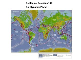
Geological Sciences 107 Our Dynamic Planet
PLANET EARTH IS A DYNAMIC EVOLVING SYSTEM - FROM 4.6 BILLION YEARS AGO TO NOW STRUCTURE & COMPOSITION REFLECT ONGOING EVOLUTION EVOLUTION DEPENDS ON HOW HEAT- "THE GEOLOGICAL LIFEBLOOD OF PLANETS" - TRANSFERRED OUT OF COOLING EARTH BY THERMAL CONVECTION (Hot stuff rises) THERMAL CONVECTION CAUSES PLATE TECTONICS: PLATES OF EARTH'S SURFACE MOVE RELATIVE TO EACH OTHER AT A FEW mm/yr (about speed fingernails grow) PLATE MOTIONS CAUSE EARTHQUAKES, VOLCANOS, MOUNTAIN BUILDING AT PLATE BOUNDARIES PLATE TECTONICS MAKES EARTH WHAT IT IS - DIFFERENT FROM NEIGHBOR PLANETS (Mars, Venus, & Earth: 3 bears principle) PLATE MOTIONS ARE CRUCIAL FOR THE ORIGIN OF LIFE, ITS SURVIVAL, AND OUR CLIMATE PLATE MOTIONS PROVIDE RESOURCES AS WELL AS HAZARDS TO SOCIETY "CIVILIZATION EXISTS BY GEOLOGICAL CONSENT"
EARTH- A LAYERED PLANET DUE TO ITS EVOLUTION THE PLATES (= LITHOSPHERE) ARE THE COLD, STRONG OUTER BOUNDARY LAYER ("thin scum": 100 / 6371 km) MOVING OVER WEAKER ASTHENOSPHERE
Earth’s surface divided up into about a dozen major lithospheric plates
NORMAL FAULTING Region under extension Wasatch Fault Salt Lake City, Utah
REVERSE FAULTING Region under compression
STRIKE SLIPFAULTING Offset fence showing 3.5 m of left-lateral strike-slip motion on San Andreas fault in 1906 San Francisco earthquake
2001 NISQUALLY, WASHINGTON EARTHQUAKE (M 6.8, $2B damage) Within subducting Juan de Fuca plate Kirby et al., 1996 Intraslab earthquakes now recognized hazard
CASCADE VOLCANOES INDICATE JUAN DE FUCA PLATE SUBDUCTION BENEATH NORTH AMERICA Mt. St. Helens: May 18, 1980 Mt Saint Helens 1980 eruption USGS
Mount St. Helens as part of the new dome collapses. USDA Forest Service photograph by taken moments after a 3.2 magnitude earthquake triggered the event on July 18, 2005 www.fs.fed.us/gpnf/volcanocams/msh
TRANSFORM- San Andreas Fault System: Motion Between North American & Pacific Plates
1906 SAN FRANCISCO EARTHQUAKE (Magnitude 7.8) ~ 4 m of slip on 450 km of San Andreas Fault ~2500 deaths, ~28,000 buildings destroyed (most by fire)
ICELAND - Part of the Mid-Atlantic Ridge - Made of Recently Erupted Basalt - Formed in past 15 million years North American plate Eurasian plate 20 mm/yr Thingvellir
1973 Eruption on the island of Heimaey, Iceland
East Africa Rift - New Spreading Center Forms by Rifting Continental Crust Africa is splitting up into Nubia (West Africa) and Somalia (East Africa)
2001 Eruption near Goma, Congo Along the East African Rift
COMPLEX PLATE BOUNDARY ZONE IN SOUTHEAST ASIA Northward motion of India deforms large region Many small plates (microplates) and blocks Molnar & Tapponier, 1977
India subducts beneath Burma microplateEarthquakes occur at plate interface along the Sumatra arc (Sunda trench)Largest & most destructive earthquakes results from many years of accumulated motion
BETWEEN EARTHQUAKES: India subducts beneath Burma at about 20 mm/yr Fault interface is locked EARTHQUAKE: Fault interface slips, overriding plate rebounds, releasing accumulated motion and generating tsunami SUMATRA TRENCH BURMA INDIA Tsunami generated Stein & Wysession, 2003 HOW OFTEN: Fault slipped ~ 10 m --> 10000 mm / 20 mm/yr = 500 yr Faults aren’t exactly periodic - intervals vary Crucial for assessing hazards
Earthquakes rupture a patch along fault's surface. Generally speaking, the larger the rupture patch, the larger the earthquake magnitude. Initial estimates from the aftershock distribution show the magnitude 9.0 Sumatra-Andaman Islands Earthquake ruptured a patch of fault roughly the size of California, and modeling seismic waves show that most of the slip occurred in the southern 400 km of the patch. For comparison, a magnitude 5 earthquake would rupture a patch roughly the size of New York City's Central Park.
MAGNITUDE 9 EARTHQUAKES ARE INFREQUENT Stein & Wysession after IRIS
TSUNAMI - water wave generated by earthquakes, volcanic eruptions & landslides NY Times
TSUNAMI GENERATED ALONG FAULT, WHERE SEA FLOOR DISPLACED, AND SPREADS OUTWARD Hyndeman and Wang, 1993 Red - up motion, blue down http://staff.aist.go.jp/kenji.satake/animation.gif
TSUNAMI SPEED IN DEEP WATER of depth d c = (gd)1/2 g = 9.8 m/s2 d = 4000 m c = 200 m/s = 720 km/hr = 450 m/hr Tsunami generated along fault, where sea floor displaced, and spreads outward Reached Sri Lanka in 2 hrs, India in 2-3 http://staff.aist.go.jp/kenji.satake/animation.gif
TSUNAMI WARNING Because seismic waves travel much faster (km/s) than tsunamis, rapid analysis of seismograms can identify earthquakes likely to cause major tsunamis and predict when waves will arrive Deep ocean buoys can measure wave heights, verify tsunami and reduce false alarms
HOWEVER, HARD TO PREDICT EARTHQUAKES recurrence is highly variable Sieh et al., 1989 Extend earthquake history with geologic records -paleoseismology M>7 mean 132 yr s 105 yr Estimated probability in 30 yrs 7-51%
PLATE TECTONICS IS DESTRUCTIVE TO HUMAN SOCIETY BUT CRUCIAL FOR HUMAN LIFE Plate boundary volcanism produces atmospheric gases (carbon dioxide CO2 ; water H2O) needed to support life and keep planet warm enough for life ("greenhouse" ) May explain howlife evolved on earth(at midocean ridge hot springs) Plate tectonics raises continents above sea level Plate tectonics produces mineral resources including fossil fuels Press & Siever
“CIVILIZATION EXISTS BY GEOLOGICAL CONSENT - SUBJECT TO CHANGE WITHOUT NOTICE” The same geologic processes that make our planet habitable also make it dangerous