Download
1 / 1
10 likes | 172 Views
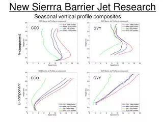
SLR. A.G. GPS. 1 cm. 3 µGal. Combining geodetic techniques to understand the seasonal effects affecting vertical positioning. Joëlle Nicolas 1 , Michel Van Camp 2 , Jean-Mathieu Nocquet 3 , Jacques Hinderer 4 , Pascal Gegout 4 , Tonie van Dam 5.

E N D
SLR A.G. GPS 1 cm 3 µGal Combining geodetic techniques to understand the seasonal effects affecting vertical positioning Joëlle Nicolas 1, Michel Van Camp2,Jean-Mathieu Nocquet 3,Jacques Hinderer 4,Pascal Gegout 4, Tonie van Dam 5 1ESGT-Laboratoire de Géodésie et Géomatique (L2G), 1, Bd Pythagore, Le Mans F-72000, France 2Royal Observatory of Belgium, Avenue Circulaire 3, Bruxelles BE-1180, Belgium 3Géosciences Azur, Bât 4, 250 rue Albert Einstein, Les Lucioles 1, Sophia Antipolis,, ValbonneF-06560, France4EOST/IPGS, 5 rue René Descartes, Strasbourg Cedex F-67084, France 5European Center for Geodynamics and Seismology, 19 Rue Josy Welter, Walferdange L-7256, Luxembourg joelle.nicolas@esgt.cnam.fr * mvc@oma.be * jean-mathieu.nocquet@geoazur.unice.fr * Jacques.Hinderer@eost.u-strasbg.fr * Pascal.Gegout@eost.u-strasbg.fr * tvd@ecgs.lu Results Introduction Time series at Grasse Observatory (France) Vertical component and gravity variations Seasonal variations are commonly observed in site position time series derived from space geodetic techniques with larger amplitude for the vertical component. These seasonal signals are mainly due to crustal deformations induced by the mass loading effects (atmosphere, ocean, snow, and soil moisture). To better understand the observed seasonal signals and to avoid artifacts linked to the technique or to the analysis strategy, it is essential to perform a multi-technique analysis. The OCA Grasse observatory, France, operates collocated SLR and GPS space techniques. Moreover, several absolute gravity measurements were performed with FG5 to monitor the long term stability of the observatory which is set up on a 1270 m high karstic plateau. In this study, we compare the time series obtained from absolute gravity measurements, from combined LAGEOS-1 and -2 SLR solutions, and from GPS weekly solution for the vertical positioning, from 1998 to 2003. The geophysical annual vertical signal presents a magnitude of 5-6 mm. The absolute gravity signal presents amplitude of several µGal. Results are compared with different global mass loading models. We study the influence of the local topography and of the Mediterranean closed sea, which could act as a non-inverted barometer where all pressure effects are fully transmitted to the Earth. The annual vertical signal observed in SLR and GPS vertical positioning time series is mainly explained by continental hydrological mass loading. The seasonal gravity signal coming from regional effects is isolated from local effects such as hydrology variations in the karst. Indeed, the difference between space geodetic positioning and gravity variations gives some indications concerning the hydrological variations and particularly the ground water table located under the OCA observatory. Figure 1: Laser and GPS vertical positioning (mm) and Absolute Gravimetry (µGal) time series at the OCA Grasse Observatory (France). There is NO conversion from AG change to height variation. The positioning is relative to ITRF2000 a priori solution and the AG values are relative to the AG mean value over the whole period. Data Annual signal 5 years of Satellite Laser Ranging (SLR) time series Both GPS and SLR times series of the vertical component show a significant annual signal. Its magnitude is 5.5 mm for the GPS time series and 6.1 mm for SLR. The maximum of the annual signal is observed in July for both the GPS and SLR. The influence of the time series computation strategy can be of the order of 1 mm in estimating the annual signal amplitude. Thus, it indicates the robustness of the annual signal and its geodynamical origin instead of computation artifacts. The AG time series shows a signal more delicate to analyze. Estimating an annual term to the AG time series leads to a magnitude of 1.4 µGal, equivalent to 6.9 mm taking the Bouguer and free air corrections into account (-0.2 µGal/mm), but the frequency analysis indicates a second principal term with a period of 204 days and a magnitude of 2.6 µGal equivalent to a vertical displacement 13 mm. However, the lack of data could mask an annual signal. The variations are larger than GPS and SLR. A possible explanation for this discrepancy is the contribution to gravity measurement of water masses variations stored in the karsts. There is no secular gravity variation higher than what is physically detectable, i.e. ~0.7 µGal/yr at the 2 level. • Semi-dynamic approach with 10-day arcs of orbit computation with the GINS software (CNES, France) • LAGEOS-1 and -2 satellite (6000 km) combined solution • 30-day station coordinate adjustment • Solution from October 1997 to October 2003 • ITRF2000 (Altamimi et al., 2002) a priori solution • GRIM5-S1 gravity field (Biancale et al., 2000), IERS96 standards (Mc Carthy, 1996) • No loading effect • Typical 1-s standard deviation of the vertical component: 3 mm • 6 years of GPS time series • Weekly CODE (Centre for Orbit Determination in Europe) position solutions • Zenith delay corrections estimated relying on the wet-Niell mapping function, with a parameter estimated every 2 hours • One N-S and one E-W horizontal delay parameter per day for each station solved for (Rothacher et al., 1997). No constraint applied on both zenith and gradient parameters Impact of the Newtonian effect • Positioning expressed in ITRF2000 with CATREF software (Altamimi et al., 2002) • IERS96 conventions (Mc Carthy, 1996), correction for ocean tides (Scherneck, 1991) • No atmospheric loading correction • Solution from January 1998 to September 2003 • Typical standard deviation on the vertical component: 4 mm (1-s level) The AG measurements result from the combination of the crustal deformation and of the Newtonian effect. Initially, the conversion of the AG measurements in vertical displacements were performed with a ratio of – 0.2 µGal/mm (i.e. – 5 mm/µGal). But this gradient should be time variable, for instance because of the water mass redistribution on the Earth surface. Therefore the conversion of gravity into vertical displacement is dangerous when loading effects are considered. So, we performed no conversion from AG change to height variation in this study. Since a possible explanation for discrepancy between GPS, SLR and AG annual amplitudes would be the contribution to gravity measurement of water masses variations stored in the karsts, we performed a simulation to estimate the size of the ground water table located under the observatory required to explain the AG variation observations (up to 8.8 µGal). For instance, it would be explained by 5 m water level variation of a cylindrical ground water table located at a depth of 800 m with a 1 km radius for 10% porosity. But we do not have enough information on the ground water table (deep, size…) located under the Grasse observatory to conclude since the underground structures with permeable and impermeable layers are not well known in this area (Gilli, personal communication, 2004). 14 Absolute Gravity (AG) measurement campaigns • Measurements performed with 2 FG5s (EOST and ORB) • The two FG5s involved in this study have been regularly compared and the differences accounted for (Van Camp et al., 2003) • Gravity values corrected for earth tides, ocean loading, polar motion, and local atmospheric effects (- 0.3 µGal / hPa due to loading and to mass attraction) • FG5 accuracy 1-2 µGal