Approach
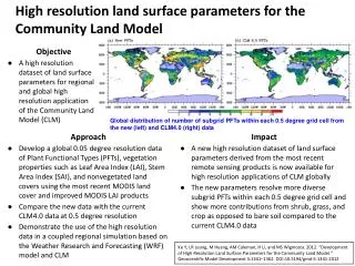
High resolution land surface parameters for the Community Land Model. Objective A high resolution dataset of land surface parameters for regional and global high resolution application of the Community Land Model (CLM).

Approach
E N D
Presentation Transcript
High resolution land surface parameters for the Community Land Model • Objective • A high resolution dataset of land surface parameters for regional and global high resolution application of the Community Land Model (CLM) Global distribution of number of subgrid PFTs within each 0.5 degree grid cell from the new (left) and CLM4.0 (right) data • Approach • Develop a global 0.05 degree resolution data of Plant Functional Types (PFTs), vegetation properties such as Leaf Area Index (LAI), Stem Area Index (SAI), and nonvegetated land covers using the most recent MODIS land cover and improved MODIS LAI products • Compare the new data with the current CLM4.0 data at 0.5 degree resolution • Demonstrate the use of the high resolution data in a coupled regional simulation based on the Weather Research and Forecasting (WRF) model and CLM • Impact • A new high resolution dataset of land surface parameters derived from the most recent remote sensing products is now available for high resolution applications of CLM globally • The new parameters resolve more diverse subgrid PFTs within each 0.5 degree grid cell and show more contributions from shrub, grass, and crop as opposed to bare soil compared to the current CLM4.0 data Ke Y, LR Leung, M Huang, AM Coleman, H Li, and MS Wigmosta. 2012. “Development of High Resolution Land Surface Parameters for the Community Land Model.” Geoscientific Model Development 5:1341–1362. DOI:10.5194/gmd-5-1341-2012