Download
1 / 36
360 likes | 739 Views
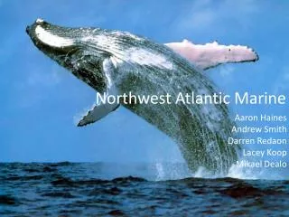
Northwest Atlantic Coastal Indicators Workshop. January 6-8, 2004 Durham, NH. SPONSORS. Background Information.

E N D
Northwest Atlantic CoastalIndicators Workshop January 6-8, 2004 Durham, NH
Background Information • Development of a regional monitoring program for the northeast Atlantic region (Atlantic Ocean from New York to Maine and the Bay of Fundy, Canada) began in 2002 with development of a framework for coordinated monitoring. • The regional monitoring framework was developed with support from the Oceans Coastal and Protection Division of EPA and in collaboration with the states and Canadian provinces in the region. • The effort was expanded in January 2003 through a workshop to identify indicators in six important regional focus areas.
Background Information • Regional Effort to Coordinate Monitoring\ Indicators • Vision: A sustainable Northwest Atlantic ecosystem that ensures environmental integrity and that supports and is supported by economically viable, healthy human communities. • Mission: To track the status and trends in ecosystem integrity throughout the Northwest Atlantic region through collaborative partnerships. To provide information for management decisions at regional and local scales. • The goal of the 2003 Indicators Workshop was to develop consensus on key indicators though for which regional data would be compiled and tracked to demonstrate trends in ecosystem integrity throughout the Northwest Atlantic region.
Background Information • Indicator Workshop focused on indicators applicable to the northeast coastal region under six focus areas • Fisheries • Contaminants • Eutrophication • Coastal Development • Aquatic Habitat • Climate Change
Why a regional effort? • Regional councils are gaining visibility and importance because of: • Consistency in informing decision-makers and public on progress in coastal protection and restoration • Making sure we are monitoring the right things • Address gaps between monitoring and management by reaching out to managers to ensure our work is relevant • Working on constituency and meeting management needs
Information Identified During Breakouts • For each of the six focus areas • Conceptual Models • Key questions • Indicators, spatial and temporal scales, and users of the data were discussed and modified as needed during the breakout sessions
Fisheries Top Questions What is the health of the fisheries with regard to ecosystem integrity, including targeted and non-targeted species, habitat, and fisheries activities? • What are the trends in characteristics and the status of exploited fisheries species? • What are the effects of fishing on non-targeted species and their associated communities? • What are the effects of fishing and non-fishing activities on marine habitat and fisheries productivity? • What are the trends in the socioeconomic characteristics of fisheries?
Fisheries Indicators What are the trends in and the status of exploited fisheries stocks? • Indicator(s): • Proportion of stocks at or above targeted abundance or biomass • Age/Size structure of species from surveys and/or landings • Spatial distribution of fisheries species • Spatial and Temporal Scales: Range of species or stocks; Annual to every 3-5 years
Fisheries Indicators What are the effects of fishing on non-targeted species and their associated communities? • Indicator(s): • Characteristics of bycatch and discards • Population levels for selected species • Species Diversity • Spatial and Temporal Scales: Regional based on populations or stock, biogeographic boundaries; Seasonal
Fisheries Indicators What are the effects of fishing and non-fishing activities on marine habitat and fisheries productivity? • Indicator(s): • Area closed to fishing, both pelagic and/or benthic • Benthic diversity • Spatial distribution of bottom fishing • Spatial and Temporal Scales: Region wide (based on biogeographic boundaries); 1 to 5 years depending on habitat to annually to continuous
Fisheries Indicators What are the trends in the socioeconomic characteristics of fishing? • Indicator(s): • Days at sea • Fleet composition • Commercial and recreational fishing economic value • Angler satisfaction • Overcapitalized fleets • Natural capital value • Market value for consumers
Contaminants Top Questions • How are contaminants in the region changing? • How is the input of contaminants changing over time and space? • Are management actions changing the extent and severity of human health effects? • How well are contaminant management actions protecting ecosystem integrity?
Contaminants Indicators How are contaminants in the region changing? • Indicator(s): • Area of sediments that have contaminant levels above sediment quality guidelines • Level of contaminants in representative non-migratory organisms • Area of shellfish bed closure by state by year • Days of beach closure due to bacterial contamination by state by year • Spatial and Temporal Scales: Specific water body scales; Event to Annual to Decadal
Contaminants Indicators How is the input of contaminants changing over time and space? • Indicator(s): • Annual chemical load to water bodies by state • Number of bacterial source investigations and sources eliminated by year by state • Spatial and Temporal Scales: Water bodies Region wide; Annual to source specific
Contaminants Indicators Are management actions changing the extent and severity of human health effects? • Indicator(s): • Incidences of human disease caused by consumption of fish and shellfish and recreational contact • Level of contaminants in representative fish/shellfish and at-risk humans • Annual number of beach and shellfish closures (reopenings) • Spatial and Temporal Scales: Water bodies Region wide; Annual to source specific
Contaminants Indicators How well are contaminant management actions protecting ecosystem integrity? • Indicator(s): • Sediment quality measure by triad approach • Incidence of disease • Reproductive success • Quality of habitats as affected by contaminants • Spatial and Temporal Scales: Water bodies region wide; Annual to decadal scales
Eutrophication Top Questions • What is the extent, severity, and trends of eutrophication impacts? • What are the sources of nutrients, can they be controlled, how are they changing? • What is the state of management measures and how can they be optimized? • What are the appropriate indicators, thresholds, and scales? • What are the most important data gaps and research/monitoring needs? How can they be translated to regional/national strategy?
Eutrophication Indicators What is the extent, severity, and trends of eutrophication impacts? • Indicator(s): • Dissolved oxygen • Chlorophyll a • Submerged aquatic vegetation • Water clarity • Spatial and Temporal Scales: Estuary-wide; Seasonal to annual
Eutrophication Indicators What are the sources of nutrients, can they be controlled, how are they changing? • Indicator(s): • Measured and modeled loads • Land use/cover (load proxy) • Population (load proxy) • Spatial and Temporal Scales: Regional; Seasonal to annual to decadal
Eutrophication Indicators What is the state of management measures and how can they be optimized? • Indicator(s): • Dissolved oxygen • Chlorophyll a • Submerged aquatic vegetation • Water clarity • Measured and modeled loads • Land use/cover (load proxy) • Population (load proxy)
Aquatic Habitat Top Questions Coastal Habitat = watersheds+ estuaries+ near and offshore • How is the extent, distribution, or use of coastal habitats changing over time? • How is the ecological condition of coastal habitats changing over time? • What are the causes of coastal habitat change over time?
Aquatic Habitat Indicators How is the extent, distribution, or use of coastal habitats changing over time? Indicator(s): • Extent per habitat type over time • Large scale mapping, small scale ground surveys • Distribution per habitat type • Inventory of human use • Area, percent of public vs. private • Area, percent designated for permanent habitat protection
Aquatic Habitat Indicators How is the ecological condition of coastal habitats changing over time? • Indicator(s): • Community Structure • Measure of change of relative abundance of species within habitat • Trophic Structure • Species of Concern
Aquatic Habitat Indicators What are the causes of coastal habitat change over time? • Indicator(s) of most important potential causes of habitat loss and degradation (physical and hydrologic alteration, nutrient loading, resource extraction, contaminants, climate change, sediment input) • Extent and percent habitat area altered by tidal restrictions • Boat registrations • Seagrass Nutrient Pollution Index • Indicators relating to other causes assumed covered by other groups
Coastal Development Top Questions • What is the type, pattern, and rate of land use change? • How are these changes impacting the integrity of coastal ecosystems? • How is the region responding to changes in coastal ecosystems?
Coastal Development Indicators What is the type, pattern, and rate of land use change? • Indicator(s): • Percent change in land cover to more intensive uses • Demographic changes (population, etc.) • Types of land uses and change
Coastal Development Indicators How are these changes impacting the integrity of coastal ecosystems? • Indicator(s): • Integrity of coastal ecosystems for: • Threatened and endangered coastal species • Migratory species • Invasive species
Coastal Development Indicators How is the region responding to changes in coastal ecosystems? • Indicator(s): • Land conservation • Habitat Restoration • Land Management (planning, regulatory, etc)
Climate Change Top Questions • What are the causes? • What are the impacts of climate changes to: weather, atmospheric & ocean circulation, ecosystems, and society. How vulnerable are we? • What are the societal responses?
Climate Change Indicators What are the impacts of climate changes to: weather, atmospheric & ocean circulation, ecosystems, and society. • Indicator(s): • Precipitation trends • Storm frequency and intensity • Water temperature surface bottom • Relative sea level rise • Spatial and Temporal Scales: Regional; Annual to Decadal
Climate Change Indicators What are the impacts of climate change on biotic ecosystems? • Indicator(s): • Warm vs. cold water finfish species diversity • Planktonic diversity • Wetlands extent, distribution and composition • Marine diseases indices (i.e., MSX, dermo, shell disease) • Spatial and Temporal Scales: Regional; Annual
Year-One Deliverables • Produce a region-wide monitoring and indicators strategy • Principles • Priority management issue and question driven • Partner relations intensive • Phased implementation schedule • Resource sensitive • Demonstration oriented
Indicators Pilot Project • Initiate demonstration pilot • Define goals, audiences, uses • Content • Region-wide (1 theme) or sub-regional (multiple themes & indicators) • Apply indicators • Education, communication, outreach methods & materials “a process of producing and communicating policy relevant information on key interactions between people and the natural environment”
Critical Linkages • Management & regulator community involvement to frame need & buy in • Monitoring & observing community to provide data & create synthetic products • Scientific community to guide expanded monitoring and identify research needs • People/Programs with lessons to share
Form committee; set terms of reference, goals & work plan; secure seed funds & hire staff; and commence work on region-wide monitoring and indicators strategy Disseminate concept & solicit comments Produce strategy & seek seed-funds Spring 2004 Summer & Fall Winter 2004/05 Next Steps “create solid foundation for sustained effort”