Download
1 / 58
590 likes | 605 Views
Geological field work in Pakistan in northen area salt range and hazara area.

E N D
GEOLOGICAL FIELD REPORT ON SALT RANGE AND HAZARA AREA By M Hamza (BGLF19M035) DEPARTMENT OF EARTH SCIENCE UNIVERSITY OF SARGODHA 2021 1
Supervisors Dr Syed Haroon Ali shah Mr. Abdul Hanan Group members Ziad Bin Zafar (BGLF19M026) Muhammad Hamza (GL) (BGLF19M035) Ali Hussain Ghazi (BGLF19M039) Usman Zaka (BGLF19M014)Nofal Jlal Ahmad (BGLF19M037) 2
LISIT OF CONTENTS Table of Contents LISIT OF CONTENTS .............................................................................................................. 3 ACKNOWLEDGEMENTS ....................................................................................................... 5 ABSTRACT ............................................................................................................................... 6 CHAPTER 1 .............................................................................................................................. 8 Introduction ............................................................................................................................ 8 1.1 GEOGRAPHIC SETTING OF SALT RANGE ............................................................. 8 1.2 REGIONAL GEOLOGY OF SALT RANGE ................................................................... 10 1.3 PURPOSE OF THE FIELD ............................................................................................... 14 1.4 EQUIPMENT AND TOOL ............................................................................................... 15 1.5 PROJECT METHODOLOGY........................................................................................... 15 2.1 Day 1 (Station 1) ............................................................................................................ 16 Figure 7 (central salt range from google earth) ................................................................ 16 .............................................................................................................................................. 18 Figure 8 (contact b/w bhagnwala and tobra) ................................................................... 18 Figure 9 (tobra dolomite ) .................................................................................................. 18 Figure 10 (Bedding structures in baghanwala formation) ............................................. 19 Fig 11: flaggy sandstone in Baghanwal formation.............................................................. 19 Fig 12: Sharp contact between Tobra and Baghanwala Formation .................. 20 2.2 Day 2 (station 1) ........................................................................................................ 21 3
Figure 13 (khewra gorge ) ................................................................................................... 22 Figure 14 Huddows .............................................................................................................. 23 Fig 15 (Ball and pillow structure in khwera gorge) ............................................... 23 .............................................................................................................................................. 24 FIG 16 ( Khewra sandstone ) ............................................................................................... 24 III Kussak and Jutana Formation ......................................................................................... 24 Table 5(Conclusion of stop 2) .............................................................................................. 25 Figure 18 Figure 19 ............................... 26 FIG 21 (SIWALIK GROUP) .............................................................................................. 28 FIGURE 23 (FOLDS) .......................................................................................................... 28 Figure 27 (warcha sandstone) .............................................................................................. 30 Figure 28 (warcha sandstone ) ............................................................................................ 31 2.2.4 stop 3 (Ara Bisharat section) ................................................................................. 32 INTRODUCTION:............................................................................................................... 32 Chapter 3 .................................................................................................................................. 34 Introduction: ......................................................................................................................... 34 Mianwali Formation ............................................................................................................. 34 Dip and Strike: ..................................................................................................................... 35 Reservoir rocks ................................................................................................................... 36 Stop 3: Finding Fossils ..................................................................................................... 36 Stop 4: Terdian and kingriali ................................................................................................ 38 3.2 Day 5 .............................................................................................................................. 40 .............................................................................................................................................. 44 CHAPTRE 4 ............................................................................................................................ 49 4.1 Economic importance of salt range ................................................................................ 49 4.2 Economic importance of Hazara Area ........................................................................... 49 chapter 5 ................................................................................................................................... 50 References ................................................................................................................................ 58 Image source ………… Google earth .............................................................................. 58 4
ACKNOWLEDGEMENTS In the Name of Allah, the Most Beneficent, the Most Merciful. All the praises and thanks be to Allah, the Lord of the 'Alamin (mankind, jinns and all that exists). The Most Beneficent, the Most Merciful .The most Merciful who gave us the strength to be a part of this informative and knowledgeable field trip which was organized by the Department of Earth Science University of Sargodha . Thanks to our parents for their constant support and prayers. After that I would like to thanks Mr. Abdul Hannan and Dr Syed Haroon Ali accompanying us to the field and sharing their knowledge. In the end I would like to thanks all of those who made their contribution to make this field successful especially Dr. Syed Haroon Ali who made all this possible and arranged a seven day (from 23th of FEB 2021 to till 2th of March 2021) field trip to salt range and Hazara area . 5
ABSTRACT The place selected for our field trip was divided into two different regions Which were followings Salt Range Hazara area Salt range basically located in Punjab province of Pakistan. From Geological and Paleontological prospective this area got so much importance. It contain rocks with age from Precambrian (Salt range formation) to recent ( Chorgali and Murree Formation). Some world famous geologists also called it as the Museum of geology and paleontology. It was formed as a result of collision between Indian plate and Eurasian plate.The Salt Range is part of the active foreland fold belt and thrust belt of Himalayas of Pakistan. Salt range is divided into three geographical distributions that are Eastern Salt Range with the coordinate ranges from 32°30ʹ-33°N & 71°45ʹ-72°E, Western Salt Range with the coordinate ranges from 32°30ʹ-33°N & 72°-72°45ʹE and Central Salt Range with the coordinate ranges from 32°30ʹ-33°N &72°45ʹ-73°30ʹE. Eastern salt range consist of Formations like Salt range Formation, Khewra Sandstone,Khussak Formation, Jutana Dolomite, Baghanwala Formation.Western Salt Range consists of Formation like Mianwali Formation, Chhidru Formation, Amb Formation, Dandot Formation, SakesarLimstone, Warcha Sandstone. Central Salt Range consists of Sardhai Formation, Warcha Sandstone, Wargal Limestone. Salt range structure is very disturbed with faults, folds and erosion. Salt Range is known for its excellent exposures and fossiliferous horizonswhich consist of different fossils for example Brachiopods,Assilina, Nummulites, Trilobites and Cephalopods. There are many unconformities also present in this Range for example the boundary between Paleozoic and Mesozoic (P-T boundary) can be studied at excellently exposed sections this boundary exist between Chhidru Formation and Mianwali Formation.The unconformity also exists between Baghanwala Formation and Tobra Formation (dis-conformity). Some structures like cross bedding, ripple marks, salt-pseudo morphs also can be seen in this particular area. On the other hand , Hazara is a region in the northeastern part of the Khyber Pakhtunkhwa province of Pakistan. It is located east of the Indus River and comprises seven districts: Abbottabad, Battagram, Haripur, Mansehra, Upper and Torghar. Kohistan, Lower Kohistan, Hazara Basin lies within lesser Himalayan region and has undergone complex depositional and tectonic episodes responsible for accumulation of different economic minerals. Phosphate, ironstone, manganese, coal and china clay deposits reported from the area indicate 6
different sedimentary environments including deep marine to carbonate and clastic shallow marine, glaciogenic and fluvial systems. These variable environments were mainly a result of different tectonic events, which were caused by formation and rifting of Rodina, Gondwana, Pangaea, India, Madagascar and collision of India with Eurasia. Phosphate was formed in anoxic shallow marine environments during Cambrian in Sirban Member and Hazira Formation, whereas, ironstone deposits were formed in oxygenated shelf and/or residual mechanisms during nondepositional periods, e.g., at the base of Jurassic and Tertiary successions. China clay was also formed at unconformable surface at the base of Shinwari Formation of Jurassic age. Coal within Chichali Formation was formed in anoxic, organic-rich deltaic shelf conditions. Basin evolution combined with stratigraphic set up of the region has played very important role in formation and exploration of these economic mineral deposits. Figure 1 Hazara Area map Figure 2 Salt range map 7
CHAPTER 1 Introduction The salt range is one of the most important geological region in Pakistan . it is easily accessible and displayed a wide variety of geological features and paleontological events in one place .The name of the Salt Range was first used by ELPHISTON in 1808. The name Salt range is derived from the fact that the area contains huge reserves of table salt. It is located to the south of Potwar plateau, which is bound to the north by Main Boundary Thrust as shown in figure 3. . Figure 3.The location of Salt Range to the south of Potwar plateau. Salt Range is south most part of Himalayas is salt range as shown in figure 3. It extends east to west about 170 km. The main supplier of salt, gypsum and coal are Khewra, Kalabagh and Warchha respectively (kazmi and jan, 1977). In East of Salt Range there is flowing River Jhelum and in the West the Indus River is flowing while the Punjab plains are in south of Salt Range. The maximum altitude of Salt Range is at Sakesar peak which is at 1522 m from the sea level. 1.1GEOGRAPHIC SETTING OF SALT RANGE 8
Figure 4.Index map of Salt Range The Himalayan frontal fault or the Salt Range Thrust is the southern-most thrust zone along the foothills of Salt Range and Trans-Indus Himalayan ranges. The study area is located in Punjab provenance and is easily reachable form the capital Islamabad through M-2 (Motorways) the distance is about 130km from the Capital. The Range is over 200 km long strike predominantly E-W and strata generally dipping North- ward. It is bounded to the east by Jhelum River and to the west by Indus River as shown in figure 5. Figure 5. To the east and west of salt range, there flowing Jhelum and Indus rivers. Salt Range is divided into three geographical distributions: 1.Eastern Salt range: That ranges from Jhelum to Kalarkahar. 2.Central Salt range: That ranges from Kalarkahar to tillajogian. 3.Western Salt range: That ranges from Tillajogian to Indus River. 9
Figure 6: General Geological Map of Salt Range division and Lithological Continuity It consists of many anticline and synclines folds and faults. Many mines are working in this region. Himalayan salt is rock salt or halite from the Punjab region of Pakistan. It is mined at the Khewra Salt Mine in Khewra, Jhelum District, Punjab, which is situated in the foothills of the Salt Range hill system. This salt mine is world’s second largest salt mine. The vegetation is predominately of Acacia modesta and Capparisaphylla. Capparis is known for its medicinal properties and ecologically helps in protecting soil from erosion. There are other species such as wild olive trees, sheesham, zizypus (ber) etc. The climate of the Salt Range is continental and arid, changing from tropic to subtropic. Tropical air prevails during all seasons of the year except the cold winter months, when the relatively cool polar air penetrates at the tail end of high-pressure systems (cyclones). This is a cold, damp season. During summer, precipitations are connected with the equatorial, moist, southwestern (Indian) monsoon, which reaches the limits of its occurrence in West Punjab but brings the largest amounts of precipitation (more than 50 percent annually). Agriculture is limited because of the poverty of the soil and lack of water for irrigation. Small areas on the slopes and in the longitudinal valleys are being terraced for irrigation using the water of lakes and springs. In the valleys dry farming prevails. 1.2 REGIONAL GEOLOGY OF SALT RANGE One of the greatest geological provinces of the world is salt range which has almost a complete rock succession from Pre-Cambrian to Recent except for the few ages. On the southern margin of Himalayan collision, an active foreland fold-thrust belt is present which is formed in response to sub-ducting of Cratonic India beneath its own Phanerozoic sedimentary cover, in the late Cenozoic time, this fault is called salt range thrust fault. Due to salt range 10
thrust fault, the rocks which are present in this area were subjected under stresses and as a result very gentle and open folds were developed. These folds and faults represent the ductile and brittle deformation in these rocks and sediments. The stratigraphic sequence of Phanerozoic age is exposed in salt range. It is also well known for its P-T boundary, Pre- Cambrian, Cambrian strata sequences and abundance of Permian, Triassic fauna i.e. vertebral fossils (khan et al.,1986). Table 1 Stratigraphic column of Salt Range 11
1.3 PURPOSE OF THE FIELD The field was organized by Faculty of Earth Sciences : i. ii. iii. iv. To build interest in this field for fresh students. Apply their previous knowledge in field (Physical Geology , Geomorphology) To identify different lithologies. To find fossils in rocks if any. 14
v. vi. vii. viii. To measure dip and strike with Brunton compass. To identify unconformity (hiatus) in the rocks if any. To understand depositional environment. To identify primary and secondary structural features. To identify bedding plane. 1.4 EQUIPMENT AND TOOL Figure 6:Picture showing tool of field geology There were certain equipment and tools were used by us in the field to fulfill over objectives which includes: i. ii. iii. iv. Brunton Compass to measure dip and strike. Hand lens to identify fossils and grain size. Geological hammer for sample collection. Measuring Tape for measuring thickness. We really thankful to our department for allotting these precious equipment to us. 1.5 PROJECT METHODOLOGY In trip we simple first stop the secure places. Our Supervisors deliver lecture about that spot then we study samples from every outcrop with the help of brunton compass Hand lens, hammer and note down these data on notebook this data helped us in finding different lithology for every formation. Then by summing the information of observed data, structure and tectonic we find environment of deposition. we also absorb geomorphologic features of that areas. 15
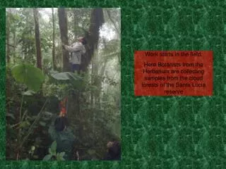
CHAPTER 2 Salt Range Field Work 2.1 Day 1 (Station 1) 2.1.1 Stop 1: Klhar khar motorway near peer Da khara We started our journey from Sargodha about 12:30 pm. We chose motorway M2 to moving toward Klar khar .we did first stop on motorway about 5 km away from Lila interchange .on this stop our supervisors just introduced us this place is known for Central salt range . OBSERVATIONS: we just observed that we are on the central salt range. Figure 7 (central salt range from google earth) 2.1.2 stop 2 Choaa saidan shah to pin dadan khan road Introduction: on the very first day we study Road side geology from choaa saidan shah to pind dadan khan road and on the road side we absorbed tobra and bhangnwala formation which was faulted by Eocene sequence of rocks. 16
I. II. III. Tobra Formation Baghanwala formation Eocene Fault OBSERVATIONS: I. Tobra Formation: Location Lithology Road side on choa saidan shah Sandstone matrix embedded with conglomeratic bed Poorly sorted Sub angular Clastic sedimentary rock Medium to coarse grained Angular to rounded Poorly sorted Striation, because of glaciers Yellowish+Pinkish+brownish Yellowish brown Sorting Grain shape Clastic/Non-clastic Grain size Grain shape Sorting Features Fresh colour Weathered colour Table 2 (Obserbation of stop 2) CONCLUSION: Formation Age Group Depositinal Environment Tobra Formation Permian Nilawahan Group Glacio-fluvial Table 2 (Conclusion of stop 2) II. Baghanwala formation: OBSERVATION : Location Lithology Fresh color Weather color Grain size Grain shape Sorting Bedding thickness Features Contact Choasaidan shah road Sandstone, shale and red clay Reddish greenish Reddish Fine grain Rounded well sorted Thin to medium bedding Salt pseudomorphs Unconformable contact with Tobra Formation Table 2: (Observation of stop 2) CONCLUSION: 17
Formation Depositional Environment Age Group Baghanwala Formation Lagoonal and Arid climate Cambrian Jehlum Table 2: (Conclusion of stop 2) Overall area was very uniquely full with lots of geomorphologic features and geological structures. we also absorbed some ripple marks and Chanel like structures of rocks and some plane which was extensively giving us foot prints to glacial and fluvial environments. As pictures are describing below. Figure 8 ( Contact with bhangwala and tobra) Figure 8 (contact b/w bhagnwala and tobra) Figure 9 (tobra dolomite ) 18
cgf Figure 10 (Bedding structures in baghanwala formation) Fig 11: flaggy sandstone in Baghanwal formation 19
Fig 12: Sharp contact between Tobra and Baghanwala Formation 20
2.2Day 2 (station 1) 2.2.1stop 1 khwera Gorge INTRODUCTION in day 2 we very attentively visit khewra Gorge. First of all in khewra gorge we saw pr Cambrian age of rocks which is known for his type locality our concerns is Salt range. In salt range we see all three members of salt range and after that we quickly learned about gorge concept and then started our journey on khewra gorge. In this gorge we collect hundreds of rock samples which were coming from different sequences of rocks with the flow of stream. Observation: I. II. III. salt range all three members khewra sandstone Kussak and jutana Formation Location Khewra gorge near salt mine Lithology Gypsum, Marl, Salt Member Bandar Kas Gypsum Sahwal Marl Billianwala salt Fresh color Marl (Bright orange) Gypsum( White) Weather color Marl (reddish + orange) Gypsum ( White/Greyish) Grain size fine grain Grain shape Rounded Sorting Well sorted Bedding thickness Thick bedding Features Gypsum is easily scratched With Finger Nail and form lenses Marl show effervescence, Efferevescence Yes, in marl. Table 22: (Observation of day2 stop 1) Smooth and Gritty CONCLUSION: Formation Salt Range Formation Age Precambrian Depositional Environment Evaporitic Environment Table 23: (Conclusion of stop 1) 21
Figure 13 (khewra gorge ) we also seen some huddows in khewra gorge their thickness about 100 to 150 feet. It is very beautiful Feature in geomorphology. 22
Figure 14 Huddows Fig 15 (Ball and pillow structure in khwera gorge) Ii : Khewra sandstone Along the stream we also observed contact between khewra and bhagnwala formation and also correlates with stratigraphic map of salt range. As can be seen in Figure 16 below. OBSERVATIONS: Location Lithology Outcrop Fresh colour Weathered colour Grain size Grain shape Khewra gorge Compacted sandstone. Clastic sedimentary rock Light reddish (purplish tone) Blackish red Fine grained Sub rounded to rounded 23
Sorting Bedding thickness Primary features Secondary features Fossils Well-sorted Thick to massive bedding Cross bedding Highly Fractured No fossil was observed Table 2(Observation of stop 1) CONCLUSION: Formation Group Depositioal Environment Age Khewra Sandstone Jhelum group Cambrian Table 3(Conclusion of stop 1) FIG 16 ( Khewra sandstone ) III Kussak and Jutana Formation Along the way on stream we also see very sharp contact between khewra and kussak formation which very sharp I have ever seen. That can be seen in figure OBSERVATIONS: 24
Location Lithology Outcrop Fresh colour Grain size(shale) Grain size(sandstone) Friability Fisciblity Fossils Primary features Secondary features Bedding plane Khewra gorge Sandstone and shale. Clastic sedimentary rock Greenish grey. Fine grain Medium to coarse grained Sandstone is less compacted. Fisciblity where shaly content is present Burrows Ripple marks and Glauconitie mineral Burrows, fracturing and tilting Bedding plane exist between sandstone and shale. Thin to medium bedding Well sorting. Moderately sorted Table 4(observation of stop 2) Bedding thickness Grain sorting(shale) Grain sorting(sandstone) CONCLUSION: Fomation Depositional environment Khussak Formation Deep Marine (Burrows and glauconitie indication of deep marine) Cambrian Jhelum group Age Group Table 5(Conclusion of stop 2) Figure 17 (khewra sandstone and kussak contact ) 25
Figure 18 Figure 19 The day was very hot, but along the way on gorge we at last reached kussak peak where we could see Jutana formation that was our goal to climb the peak of kussak on that day. Figure 20 (Jutana Formation ) 26
Day 3 (station 1) 2.2.2Stop 1 Nagri Formation (siwalik group) Introduction: On day 3 of our field work we got up early in the morning and we quickly visit the road side geology where we can see escarpment views of different rocks. So in that day we observed these below formation and learned the whole concept of folds and fault which is related to structural geology . Nagri Formation (siwalik group) Folds and Faults in kussak ,Jutana and Baghnwala Observation: Location Lithology Clastic/Non-Clastic Fresh colour Weathered colour Grain size Sorting Grain shape Friability Wahali village road Major sand minor clay Clastic Sedimentary rock White to greyish Yes CONCLUSION: Formation Age Group Depositional Environment Nagri Miocene Siwalik Fluvial deposition Table 17(conclusion of stop 3) 27
FIG 21 (SIWALIK GROUP) FIGURE 23 (FOLDS) 28
2.2.3stop 2 Dandot Formation INTRODUCTION: From the stop 2 we again start our journey and encountered an another exposed outcrop. We collect sample from it and note down its fresh colour as well as weather colour. We observe grains in the hand lens and found that it is sandstone. It was contact of dandot formation and warcha sandstone. OBSERVATIONS: Location Lithology Grain size Sorting Bedding thickness Diagnostic criteria Near wahali village Sandstone Medium to coarse grained Moderately sorted Thick to massive bedding. Phosphorus Nodules Table 18.(Observations of Dandot formation) CONCLUSION: Formation Age Group Depositional Dandot Formation Permian Nilawahan Deltaic environment Table 19 (conclusion of stop 4) 2.2.3 Stop 3: Warcha Sandstone OBSERVATIONS: Location Lithology Clastic/Non-Clastic Fresh colour Weathered colour Grain size Sorting Grain shape Friability Wahali village Sandstone Clastic Sedimentary rock White to greyish tone Yellowish brown Coarse grain Well sorted Angular Yes Table 16(Observations of Warchasanstone) CONCLUSION: Formation Age Warcha sandstone Permian 29
Group Depositional Environment Nilawahan Fluvial deposition Table 17(conclusion of stop 3) 30
Figure 27 (warcha sandstone) Figure 28 (warcha sandstone ) 31
2.2.4stop 3 (Ara Bisharat section) INTRODUCTION: in ara bisharat section we observed three formation which was sequence of Paleocene of rocks and known as makarwal group . In this section Lockhart limestone was absent. Observation: Hangu and Patala Formation Patala formation is exposed in patala nala in slat range . this formation consist of shale and marl with subordinate limestone and sandstone, with coal locally . In salt range the shale is dark greenish grey as can be seen in below pic . But on the other hand Hangu formation consist of sandstone with grey shale . tha sandstone is white , fine to coarse grained with fossile contains of gestropods. The contact between both formation can be seen in below figure. Figure 29 ( contact between Hangu /patala) 32
TRAVELE FROM KATAS RAJ TO MIANWALI [NAMAL GORGE] 33
Chapter 3 3.1 Day 4 (Station !) Introduction: In day 4 we get up early in the morning and we travel Katas raj to Mianwali. We reached Namal, which is approximately 31 km behind Mianwali city and started our work. We entered in a gorge which is named as Namal gorge. We started walking and Sir Haroon started to give us all the information about the gorge, firstly he give us the information about the hanging and foot walls and the so on. We also see anticline structure of Namal gorge. Formation Description Mianwali Formation Age Lower Triassic Name Mianwali Formation Lithology Shale, varied facies Type locality Not designate, reference sections, Zaluch, Nala, Western salt range and Tappan Wahan, Khisor range Fossils Cephalophodes Brachopoids Conadonts 34
Contact Type Lower Percomfirmable Stop 1 Dip and Strike: Dip is the acute angle that a rock surface makes with a horizontal plane. Strike is the direction of the line formed by the intersection of a rock surface with a horizontal plane. Strike and dip are always perpendicular to each other. 35
Stop 2 Reservoir rocks At stop 2, we see the porous rocks which afterwards told by Sir Haroon that these rocks are called Reservoir rocks. A reservoir rock is a rock providing a condition to trap oil in porous media. The reservoir rock contain pores and throats creating a flow path. Here Sir Haroon told us that he has specialization in this rock type. Stop 3: Finding Fossils At stop 3, Sir Haroon ask us to find the fossils of Mianwali formation. We started to find fossils, sir asked us to find firstly, Brachiopods. All of us found best brachiopods. 36
Then we start walking and after some distance sir stopped us and asked to find ammoinds as well as ceratits. We find both samples after a little hardwork. There is a stream floating in the garge, some of our students go to the left side of stream to get the samples of brachiopods, ammonids and also white limestone. Here we find another cake type sample of a sandstone named as 37
pisolitic sandstone. Stop 4: Terdian and kingriali At stop 4 Sir haroon told us the contact between 3 formations, 1st of Mianwali formation with tredian formation, tredian formation with kingriali formation. Formation Description Age Mid triassic 38
Name Tredian Formation Lithology Non marine unit, sandstone shale Locality Non designated, ref section zaluch, Nala, Western salt range and tapanwahan, khisor range Fossils Microplants fossils Contact type Confirmable Formation Description Age Mid triassic Name Kingriali Formation Lithology Dolomite and dolomite limestone, marl and shale Locality Non designated, ref section zaluch, Nala, Western salt range and tapanwahan, khisor range. Contact type Upper unconformable. Fossils Brachiopods and bivalves. Conclusion: So at last one that we complete our journey in Namal gorge. Here we collect of lots of samples of brachiopods ammonides and ceratites.and we also see very big view of Musakheel group .Then our supervisors decided to travle toward Abbotobad. 39
3.2 Day 5 It was day 5th. On this day , we take 5 stops on different regions and we analyse different formations and we stayed 5 time on roadside. In five stops we anaylyse and study following formations; Stop 1 Hazara Formations Stop 2 Tanawal Formation Stop 3 Mansehra Granite Complex Stop 4 Nara Section Stop 5 Sassur Gali Top Stop 1 Observation Hazara Formation Locality : confirmable Lithology : Age: Precambrian Fossils : Shale , slate Contact :Upp with Tanawal formation Stop 2 Tanawal Formation Synonymy: Wynee 1978------- Tannol Group Latif 1970------- Tannol Formation Locality: Abbatabad Formation Lith logy: quartos , schist, quartzite and schistose 40
Age: Precambrian Fossils: ----- Contact: upper contact with abbatabad formation and lower contact with hazara formation Figure 1 Day 5 (Hazara formation) Figure 2 Day 5 (Tanwal Formatio Stop3 41
Mansehra granite complex: in Stop4: 42
Nara section: In Nara section ,here we observed bigger grain size of granite Stop5: 43
Sassur Gali top: final point where Black Mountain can be seen clearly. Black Mountain granite have traces of uranium and there is the large scale of mining at this place Sassur gali At main sheer zone granite shows actually nassocity. top is Economic importance of black mountains: Black granite is very abundant in these mountains have very geological importance to this area.They have abundant mineralization 44
Day 6 We visited following formations Stop 1 PMA kakrol Stop 2 Samana suk formations Kawagarh formation Margala hills Stop 3 Nathia gali Chorgali Hazara formation Stop 1 45
PMA Kakrol Here is the sedimentary phosphate economic industry since 1988. In this region Namal and Sakaser limestone are absent. Kuldana formations is youngest Eocene in this region. We also saw geomorphological features there. Stop 2 Observation: Samansuk Formation Locality: NE of Shinawari (Samana Range NWFP) Lithology: Lime stone Age : Mid Jurassic Fossils: Gastropods Contact:--------- 46
Kawagarh Formation Locality: Kawagarh Hills (north of Kala Chita Cambellpur District) Lithology: Maari challor, dark and dark shale Age: Upp. Cretaceous Fossils: ----------- Contact:------- Margala Hills Locality: Jatta gypsum Quarry, Kohat NWFP Lithology: Marl, limestone Age: Early Eocene Fossils: Foraminifera, mollusk Contact:------- 47
Stop 3 Observation Nathia Gali Chorgali Formation Locality: Chorgali pass Khair-Murat Range Potwar, Punjab Lithology: Shale , Limestone Age: Early Eocene Fossils: Foraminifera and ostracods Contact: Confirmable Hazara Formations Locality : confirmable Lithology : Age: Precambrian Fossils : Shale , slate Contact :Upp with Tanawal formation After that in chargoli we again see Hazara formation there 48
CHAPTRE 4 ECNOMIC DEVOLPMENT OF SALT RANGE AND HAZARA AREA 4.1 Economic importance of salt range There are some importance of salt range as follows: It derives its name from extensive deposits of rock salt that form one of the richest salt fields in the world. It is known museum of paleontology and geology. In addition to the salt deposits, mined from ancient times, the Salt Range contains coal, gypsum, and other minerals. Traces of petroleum are associated with limestone and sandstone deposits in the western part of the Salt Range. In the salt-bearing series in the eastern part of the Salt Range, layers of bituminous Shale are found. Large deposits of high-grade gypsum and anhydrite, an important calcium mineral, are found near Jalālpur. There are many factories are working in salt range that are crushing the rocks of salt range to form cement. Best way factory is one of them. ICI factory established its first manufacturing site for the production of Soda Ash at Khewra. Moreover , if Pakistan government take decision to fix Wind turbines in salt range especially near khewra George .that will be very cheaper and best method for Punjab government to fulfill the supply of electricity. Environment of khewra George is very useable for wind turbines. 4.2 Economic importance of Hazara Area IN hazara area main sheer zone granite shows actually nassocity. top is final point where Black Mountain can be seen clearly. Black Mountain granite have traces of uranium and there is the large scale of mining at this place Economic importance of black mountains: Black granite is very abundant in these mountains have very geological importance to this area.They have abundant mineralization. 49
chapter 5 Visit to Pakistan Museum of Natural History 5.1 Day 7 (station 1 ) Now, under discussion is day 7th. It was a bright morning of Monday of March 1, 2021. And it was last day of our field work. So, our supervisors decided that, we’ll go to Pakistan Museum of Natural History for giving awareness to students. So, we checkout from our hotel at 12 am and we started our journey from Abbottabad to Islamabad. Here, I want to include a motivative sentence, before fieldwork point of view of seeing of rocks was different as compare after to field. After it I always seeing rocks and finding some sediment structures in it according to my knowledge that I have gained by fieldwork. Then, we were traveling towards Islamabad. We all were enjoying the scenario that had been made in bus. Songs were playing and every one was feeling it and enjoying it. Ups and downs of roads were increasing our excitement to go our homes back but there was a barrier of visit of museum but after visiting it, it was memorable and full of wealth of knowledge. At last, we had reached to museum at 4pm. As we mentioned above, we had two supervisors Dr. Syed Haroon Ali and Mr. Abdul Hanan. They were well-known to faculty of museum. Where Mr. Imran was our guide, he guided us briefly as he can. First of all, we got a warm welcome by the team andentered in museum. Firstly, we entered in corridor and there we saw small multimedia machines that had a software named as Visual Origin of Geology (VOG). Then, we entered in a small cave, where they had made a plastic ancient man in a cave with his all-survival tools and things. Then we saw a stuffed tortoise and snakes that were stuffed for preserving purposes. When we were outside the museum, we saw a giant skeleton of shark that increased our joy. After seeing multimedia screens, we saw a Buddha’s face rock (Atomic Bomb Hiroshima Stone) that had been given by the President of Japan to the President of Pakistan. Then we saw a cave as above mentioned and nearly in rectangular glass case, there was a stuffed large approximately 12 feet crocodile that has mentioned as ‘Gharial’ in museum. And gradually, we were going in to the museum as time was running out. Then we saw a stuffed zebra but officially this was not Pakistani, it was imported from Africa. After that, we saw a replica of wild mushrooms. Then we turned left and there were small crocodile and tortoise those were stuffed for being preserved.While moving towards next zone of museum in thecorridor, we saw different species of rabbit and vertebrate animals. 50