Download

1 / 3
0 likes | 7 Views
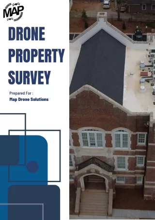
Get accurate results with a drone property survey in Georgia from Map Drone Solutions. Our advanced drone technology delivers high-resolution images, 3D mapping, and precise measurements for real estate, land development, and construction projects. Safe, fast, and cost-effective, our surveys help you make confident property decisions. Book your survey today and experience reliable aerial data that saves time and money.<br>Visit: https://mapdronesolutions.com/drone-property-survey/<br><br>

E N D
Map Drone Solutions DRONE PROPERTY SURVEY GEORGIA – ACCURATE, SAFE, AND AFFORDABLE
Why Choose Drone Surveys? A drone property survey in Georgia is one of the most efficient ways to collect accurate property data. Map Drone Solutions uses advanced drone technology to deliver high-resolution images, precision mapping, and detailed property insights for owners, real estate professionals, and developers. Accurate and Detailed Data Drone surveys capture aerial images, topographic maps, and even 3D models of land or structures. This allows experts to measure property boundaries, assess roof conditions, and monitor land development with greater accuracy than traditional methods. Safety and Efficiency Traditional surveys often require climbing or navigating risky areas. With drones, surveyors can safely collect information from hard-to-reach places without putting themselves at risk. This ensures faster, safer, and more reliable results.
Applications for Real Estate and Development Drone property surveys are especially useful in real estate, where buyers and sellers need clear insights before making decisions. Developers also use drone data for site planning, drainage design, and construction monitoring, ensuring projects stay on track. Professional Service You Can Trust By choosing Map Drone Solutions for your drone property survey Georgia, you get access to a professional team with experience in delivering precise aerial data. Their services save time, reduce costs, and provide the information you need to make confident property decisions. Contact Us 404-680-6792 1625 Conley Rd, Conley, GA 30288 https://mapdronesolutions.com/