Download
1 / 5
60 likes | 471 Views
Discharge of Contaminants Into Stream System. Diversion & Regulation of Stream Water. Structural Alteration & Development of Floodplain. Introduction and Spread of Non-native Vegetation.

E N D
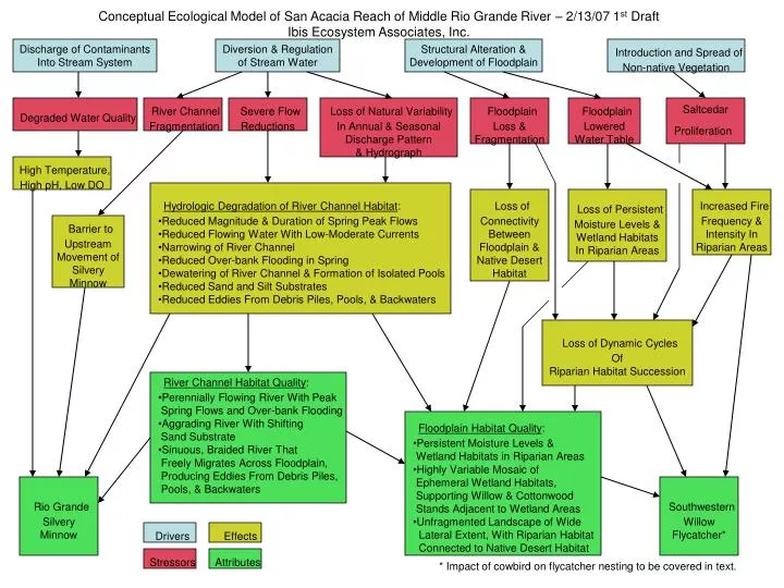
Discharge of Contaminants Into Stream System Diversion & Regulation of Stream Water Structural Alteration & Development of Floodplain Introduction and Spread of Non-native Vegetation Conceptual Ecological Model of San Acacia Reach of Middle Rio Grande River – 2/13/07 1st DraftIbis Ecosystem Associates, Inc. Degraded Water Quality River Channel Fragmentation Severe Flow Reductions Loss of Natural Variability In Annual & Seasonal Discharge Pattern & Hydrograph Floodplain Loss & Fragmentation Floodplain Lowered Water Table Saltcedar Proliferation High Temperature, High pH, Low DO • Hydrologic Degradation of River Channel Habitat: • Reduced Magnitude & Duration of Spring Peak Flows • Reduced Flowing Water With Low-Moderate Currents • Narrowing of River Channel • Reduced Over-bank Flooding in Spring • Dewatering of River Channel & Formation of Isolated Pools • Reduced Sand and Silt Substrates • Reduced Eddies From Debris Piles, Pools, & Backwaters Loss of Connectivity Between Floodplain & Native Desert Habitat Loss of Persistent Moisture Levels & Wetland Habitats In Riparian Areas Increased Fire Frequency & Intensity In Riparian Areas Barrier to Upstream Movement of Silvery Minnow Loss of Dynamic Cycles Of Riparian Habitat Succession • River Channel Habitat Quality: • Perennially Flowing River With Peak • Spring Flows and Over-bank Flooding • Aggrading River With Shifting • Sand Substrate • Sinuous, Braided River That • Freely Migrates Across Floodplain, • Producing Eddies From Debris Piles, • Pools, & Backwaters • Floodplain Habitat Quality: • Persistent Moisture Levels & • Wetland Habitats in Riparian Areas • Highly Variable Mosaic of • Ephemeral Wetland Habitats, • Supporting Willow & Cottonwood • Stands Adjacent to Wetland Areas • Unfragmented Landscape of Wide • Lateral Extent, With Riparian Habitat • Connected to Native Desert Habitat Rio Grande Silvery Minnow Southwestern Willow Flycatcher* Drivers Effects Stressors Attributes * Impact of cowbird on flycatcher nesting to be covered in text.
Diversion & Regulation of Stream Water Introduction & Spread Non-Native Vegetation Structural Alteration & Development of Floodplain • Altered Physical & • Chemical Characteristics • Of River Water: • Reduced Sediment Load • Reduced Temperature • Increased Ammonia River Channel Fragmentation Severe Flow Reductions Loss of Natural Variability In Annual & Seasonal Discharge Pattern & Hydrograph Floodplain Lowered Water Table Floodplain Loss & Fragmentation Conceptual Ecological Model of San Acacia Reach of Middle Rio Grande River – 10/07 Draft Barrier to Upstream Movement of Silvery Minnow • Hydrologic Degradation of River Channel: • Reduced Magnitude & Duration of Spring Peak Flows • Reduced Channel Avulsion During Spring Peak Flows • Reduced Over-bank Flooding During Spring Peak Flows • Reduced Flowing Water With Low-Moderate Currents • Narrowing of River Channel • Dewatering of River Channel & Formation of Isolated Pools • Reduced Sand and Silt Substrates • Reduced Eddies From Debris Piles, Pools, & Backwaters Loss of Persistent Moisture Levels & Wetlands In Riparian Areas Increased Fire Frequency & Intensity In Riparian Areas Loss of Connectivity Between Floodplain & Native Desert Loss of Dynamic Cycles Of Riparian Plant Succession, Producing Dense Even-aged Stands, & Resulting In Loss Of Habitat Mosaic • River Channel Quality: • Natural Variability In River Flow • Dynamics, With Peak Spring Flows, • Avulsion, & Over-bank Flooding • Aggrading River With Shifting • Sand Substrate • Sinuous, Braided River That • Freely Migrates Across Floodplain, • Producing Eddies From Debris Piles, • Pools, & Backwaters • Floodplain Quality: • Persistent Moisture Levels in • Wetlands & Riparian Areas • Highly Variable Mosaic of • Ephemeral Floodplain Communities, • Supporting Willow & Cottonwood • Stands Adjacent to Wetland Areas • Non-fragmented Landscape of Wide • Lateral Extent, With Floodplain • Connected to Native Desert Drivers Stressors Effects Attributes • Aquatic Communities: • Viable Populations of • Key Indicator Groups • of Aquatic Fauna • Aquatic Fauna • Community Diversity • Marsh Communities: • Creation of • New Marshes • Persistence of • Established Marshes • Cottonwood – Willow • Communities: • Seedling Recruitment • Persistence of • Established Communities Rio Grande Silvery Minnow Southwestern Willow Flycatcher
Episodic Flow Events • Recruitment-Level Flow Events • April-June • 3,000 – 4,000 cfs • 2-Week Duration • 3-Year Frequency • Hydrologic Connectivity • River Channel to Floodplain • Surface Water to Groundwater Persistent Pools As Aquatic Refugia During Dry Periods Conceptual Ecological Model of Working HypothesesAquatic Communities San Acacia Reach of Middle Rio Grande River10/07 Draft Channel Avulsion & Scouring Bank-full Flow & Dynamic In-Channel Morphology Over-bank Flow Diverse Sediment Size Distribution & Shifting Sand Substrate Backwater Nursery Habitat Prevention of Stranding With Water Level Recession River & Floodplain Management Hydrologic & Geomorphic Effects • Aquatic Habitat Heterogeneity: • Multi-Threaded Channel • Dynamic/Avulsive Channel • Channel Width/Depth Ratio • Backwaters • Woody Debris Aquatic Community Attributes Performance Measures Aquatic Fauna Community Diversity Viable Populations of Key Indicator Groups of Aquatic Fauna (Including Rio Grande Silvery Minnow) Recruitment To Adult Stage Survivorship By Age Class Population Geometric Growth Curves
Episodic Flow Events • 7,000 – 10,000 cfs • 1-week Duration • 10-Year Frequency Maintenance-Level Flow Events 3-Year Frequency • Hydrologic Connectivity • River Channel to Floodplain • Surface Water to Groundwater • Site Preparation & Management • Removal of Non-Native Vegetation • Fire Management • Other Conceptual Ecological Model of Working HypothesesMarsh Communities San Acacia Reach of Middle Rio Grande River10/07 Draft Channel Avulsion & Scouring Bank-full Flow & Dynamic In-Channel Morphology Over-bank Flow Groundwater Level • Water Level Fluctuation • Minimum 3-Foot Fluctuation • < 3-Year Frequency • Marsh Community Creation: • Active Channel Marsh Communities • Marshes Sustained by Surface Water & Groundwater • Marshes Sustained Entirely By Groundwater • Marsh Community Maintenance: • Active Channel Marshes • Marsh Community Maintenance: • Marshes Sustained by Surface Water & Groundwater • Marshes Sustained Entirely By Groundwater Frequency, Location, & Spatial Coverage of Newly Created Marshes Longevity and Succession Of Established Marshes River & Floodplain Management Hydrologic & Geomorphic Effects Spatial Coverage of Each Marsh Community Type Marsh Community Attributes Performance Measures
Episodic Flow Events Recruitment-Level Flow Events < 5-Year Frequency • Hydrologic Connectivity • River Channel to Floodplain • Surface Water to Groundwater • Site Preparation & Management • Removal of Non-Native Vegetation • Fire Management • Other Conceptual Ecological Model of Working HypothesesCottonwood - Willow Communities San Acacia Reach of Middle Rio Grande River10/07 Draft Channel Avulsion & Scouring Over-bank Flow Groundwater Level: Depth To Groundwater Of 3 – 6 Feet Creation of Scoured Habitat For Seedling Recruitment, Formation of Bars and Islands For Willow Establishment • Water Level Fluctuation • Soil Wetting May-June • Maximum Groundwater • Recession Rate of 2 – 4 cm/day River & Floodplain Management Hydrologic & Geomorphic Effects Successful Recruitment Of Cottonwood & Willow Seedlings Persistence of Established Cottonwood & Willow Communities Cottonwood/Willow Community Attributes Performance Measures Frequency, Location, & Spatial Coverage Of Seedling Recruitment Of Cottonwood and Willow Location, Spatial Coverage, & Longevity Of Established Cottonwood & Willow Communities