Download
1 / 37
380 likes | 850 Views
Use of the Vaisala Ceilometer for Boundary Layer Height Detection. Presented by: Mike Gilroy Puget Sound Clean Air Agency Seattle, WA. 907031. STI Modeling New Techniques. Vaisala CL31 Backscatter and BL Height Data (MH). DYE’S DICE .

E N D
Use of the Vaisala Ceilometer for Boundary Layer Height Detection Presented by: Mike Gilroy Puget Sound Clean Air Agency Seattle, WA 907031
STI Modeling New Techniques Vaisala CL31 Backscatter and BL Height Data (MH) DYE’S DICE *During this study, BL detected by the ceilometer never exceeded ~1,500 m agl
Acknowledgements Sonoma Technology, Inc. Patrick Zahn Charley Knoderer Clinton MacDonald Vaisala Inc Rejio Ronjininen Christoph Muenkel Herb Winston National Weather Service Office Seattle Brad Colman Kris Johnson Puget Sound Clean Air Agency Air Monitoring Team
Study Overview • Objective is to evaluate technologies to continuously measure the boundary layer (BL) depth for air quality applications. • Instrument chosen was Vaisala CL31 ceilometer. The CL31 • is relatively inexpensive; • is easy to install and operate; and • already exists at many airports. • Scheduled ASOS network upgrade • CL31 is first and foremost a cloud measuring tool. Vaisala CL31 eye-safe laser ceilometer
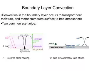
Ceilometer • The ceilometer works by emitting a laser beam vertically and detecting the reflection of the beam by particles. • The ceilometer measures • Continuous reflectivity (backscatter) • Hourly or sub-hourly BL heights from about 2 to 3,000* m agl with a vertical resolution of about 10 m • BL heights (derived from the backscatter profile) Vaisala CL31 Backscatter and BL Height Data (MH) *During this study, BL detected by the ceilometer never exceeded ~1,500 m agl
Historical Data Collection Tools • Rawinsondes • Rawinsondes are typically deployed twice daily. • Expensive • Small network • Inadequate for many analysis or model validation needs • RASS/ RWP SYSTEMS • Expensive • Fixed site, difficult to install • Good temporal resolution • Small network • Misses lowest layers (SFC-120m) • Impacted by atmospheric conditions
RASS/RWP • The RWP is a vertically pointing clear air radar that measures • Hourly or sub-hourly horizontal winds from about 100 to 4,000 m with a vertical resolution of 60 to 120 m depending on settings • Continuous reflectivity (SNR/Cn2 backscattered signal) • Continuous vertical velocity • RASS provides vertical profiles of temperature from about 100 to 1,500 m with a vertical resolution of 60 m
Air Quality Data Needs • Vertical Temperature and Wind Measurements are critical to: • Forecasting • Data analysis • Modeling • Model Validation • All benefit from temporally and spatially resolved BL information.
Study Setup Sand Point • Ceilometer was collocated with a RWP/RASS operated by the Puget Sound Clean Air Agency at the Sand Point station in Seattle – August 20–September 30, 2007- Nov 1, 2007- Feb 20, 2008 • BL heights were derived from the RWP, RASS, and ceilometer and compared statistically and through case-study analysis
Results – Time Series of BL Heights • Three cases are the subject of a time series of RWP/RASS and ceilometer BL heights. • Case 1. August 29, 2007, 2:30 am - 4:30 p.m. – Good agreement between RWP/RASS and ceilometer heights. • Case 2. September 8, 2007, 3:30 am - 7:30 p.m. – Good agreement between RWP/RASS and ceilometer heights. • Case 3. September 12, 2007 – Poor agreement due to low ceilometer heights early in the day. • Ceilometer cloud data are included in the analyses.
Results – Time Series for Cases 1 and 2 Case 1, August 29, 2007, 2:30 a.m.- 4:30 p.m. – Good agreement between RWP/RASS and ceilometer heights; period of focus: 1–2 p.m. Case 2, September 8, 2007, 3:30 a.m.-7:30 p.m. – Good agreement between RWP/RASS and ceilometer heights; period of focus: 4–5 p.m. Time (PDT)
Results – Case 1 (1 of 2) RWP SNR, objective BL heights, and final RWP/RASS BL heights (600 m from 1-2 p.m. PDT) Ceilometer backscatter and ceilometer BL heights (600 m from 1-2 p.m. PDT) • Ceilometer clouds (clear skies)
Results – Case 1 (2 of 2) • RASS Tv shows inversions beginning at 600 m and 800 m at 1:30 p.m. • RWP winds shift from northeasterly to east-southeasterly at 750 m at 1:30 p.m. • RASS Tv • RWP winds
Cloudy • Clear Results – Case 3(1 of 2) Case 3, September 12, 2007– Poor RWP/RASS-ceilometer BL height agreement early in the day, better when clouds clear. • The following slides focus on the period of disagreement: 10–11 a.m. PDT
Results – Case 3(2 of 2) RWP SNR, objective BL heights, and RWP/RASS BL heights (800 m from 10-11 a.m.) Ceilometer backscatter and ceilometer BL heights (450 m from 10-11 a.m.) • Ceilometer cloud heights (450 m from 10-11 a.m.)
Winter Conditions • La Nina did not help!
15.02.2008 • Fog in the morning, breaking up as sun rises • Low altitude mixing height day time, occasional precipitation showers
16.02.2008 • Precipitation during the night and morning • Afternoon cloud layer breaking, low inversion on evening
17.02.2008 • Night time low inversion, fog created in the morning hours • Clouds and showers in morning (at 16-19) • Nice mixing height evolution on afternoon and evening
18.02.2008 • Low inversion and night • Strong fog layer in the morning, breaking up during before noon • Fog starting to create at evening
19.02.2008 • Fog during the night, breaking up during morning • Nice evolution of convective layer • Weather front coming over in the evening
20.02.2008 • Showers of precipitation during the day as cloud front moving
Results - Data Distribution • Ceilometer can detect BL heights below 200 m. • The lack of ceilometer BL heights above 1,200 m appears to be a result of interference from clouds.
Results – Scatter Plots – Cloudy versus Clear Periods • Clear periods only; R2 = 0.594 • Cloudy periods only; R2 = 0.3536
CL-VIEW graph 7/4/2007 Part 2, 12 PM – 12 AM Significant Backscatter increase noted during 4th of July Firework’s
CL-VIEW graph 7/5/2007 Part 1, 12 AM – 12 PM Significant Backscatter increase noted during 4th of July Firework’s
Summary • RWP/RASS and ceilometer BL heights were within 200 m of one another for 78% of the test period. • The removal of cloudy periods resulted in • A significant improvement in RWP/RASS – ceilometer BL height correlation • A significant improvement in ceilometer bias (from 71 m to 55 m) to within the vertical resolution of the RWP/RASS (60 m). • The low correlation between RWP/RASS BL heights and ceilometer BL heights during cloudy periods indicated that clouds may interfere with the ceilometer’s calculation of BL heights.
Findings • The ceilometer alone is useful for determining BL heights, especially during clear conditions. • The ceilometer is useful for determining BL heights below 200 m, for which RWP wind, RASS Tv, and RWP moments data are unable to indicate such a low BL height. • Using the ceilometer may be especially useful during the wintertime when BL heights are low. • The ceilometer helps identify BL heights created by subtle atmospheric features that are not easy to discern in the RWP/RASS data.
Potential Use Nationally • This technology is very promising ! • Supplementing existing RASS/RWP Systems • Stand alone system (with other surface measurements) • Will require training to interpret data
Potential National Use • Evaluate % Cloud Ceilings < 3,000Ft in your area
Findings- Logistics • CL- 31 is easy to deploy • Cl-31 is affordable (~30K) • Reliable
Next Steps • Vaisala is completing it’s evaluation and expects to declare the Mixing Ht capability operational in 2008 • Discuss possible solution to cloud interference • Work with NWS, EPA and other to ensure Mixing Ht data is available from ASOS network. • Develop an model validation experiment in EPA region 10