Download
1 / 34
350 likes | 487 Views
World Water Online. WWO. Proposing A Distributed System for Global Water Information Presented by: Fernando R. Salas Prepared by: Fernando R. Salas and David R. Maidment University of Texas at Austin GEOSS Standards and Interoperability Forum October 18 th , 2011.

E N D
World Water Online WWO Proposing A Distributed System for Global Water Information Presented by: Fernando R. Salas Prepared by: Fernando R. Salas and David R. Maidment University of Texas at Austin GEOSS Standards and Interoperability Forum October 18th, 2011
We Collect Lots of Observations Data in Hydrology Water Quantity Rainfall Soil Water Water Quality Meteorology Groundwater
…The Consortium of Universities for the Advancements of Hydrologic Science Inc. (CUAHSI) is a consortium of 125 universities working together to advance hydrologic science in the United States… http://his.cuahsi.org
How the Web Works HTML – web language for text and pictures Harvesting Search Access
Services Oriented Architecture for Water Data WaterML – web language for water data Harvesting Search Access
WaterML as a Web Language Discharge of the San Marcos River at Luling, TX June 28 - July 18, 2002 USGS Streamflow data in WaterML The USGS now publishes its time series data as WaterML web services
CUAHSI Water Data Services Catalog All the data comes out in WaterML 69 public services 18,000 variables 1.9 million sites 23 million series 5.1 billion data values And growing The largest water datacatalog in the world
Open Geospatial Consortium – Web Service Standards • Map Services • Web Map Service (WMS) • Web Feature Service (WFS) • Web Coverage Service(WCS) • Catalog Services for the Web (CS/W) • Observation Services • Observations and Measurements Model • Sensor Web Enablement (SWE) • Sensor Observation Service (SOS) • WaterML2 – Fall 2011
Web Services Stack for Time Series OGC Catalog Service for the Web with standard metadata: ISO, Dublin Core, .. Who? What? Time Series Services Catalog (CSW) Where? When? Metadata (WFS) Data (WaterML) Access Data
Water Agency StacksEach Agency Maintains Their Own Data and Metadata USGS NCDC TWDB MetaCatalogis a listing of the URL addresses of all agency catalogs Structure is similar to GEOSS
Searching Federal, State and Local Data Catalog Metadata
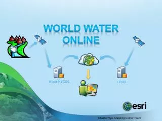
World Water Online Models Flooding, Water Availability, Water Quality World Water Online Water Observation Sites, Structures, Streamflow, Groundwater, Water Quality Climate Temperature, Evaporation, Precipitation, Soil Water, Solar Radiation Geospatial Elevation, River Networks, Watersheds, Land Cover, Land Use Inspired by Rob Vertessy, CSIRO, Australia
Climate Data • Many groups distribute climate data (national and global data) • Precipitation, Evaporation, Temperature etc. • Observations (i.e. GPCC), Remote Sensing, Models/Reanalysis (i.e. CFSR) and Predictions (i.e. IPCC) • Which products should be used within a global system?
The Digital Divide Climate Observations and Grids Observations and Time Series Geographic Information Systems (GIS) Remote Sensing
Interoperability Challenges Observations Data Gridded Data Measures variables over a continuous space-time domain Stored in large multi-dimensional arrays in specialized formats • Measures variables over a discrete space-time domain • Stored in tables, relational databases and geodatabases How can we connect these very different worlds together?
Observations Data Information Model Data Source • United States Geological Survey (USGS) Network • National Water Information System – Unit Values Sites • Colorado River at Austin Variables • Streamflow Values • 2,500 cfs at 8:30 am on • June 19th, 2011
Multisensor Precipitation Estimate (MPE) West Gulf River Forecast Center Exported by NWS to CUAHSI Observations Data Model and WaterML web services at University of Texas at Arlington Capital Area Council of Governments (CAPCOG)
Situational Awareness for Flash Flooding in the CAPCOG region National Weather Service, USGS, Corps of Engineers Combines federal, river authority, city and water district data …. …. to support real-time flood emergency response
Rainfall in Cypress Creek WatershedDrainage area – 38 Sq. Mi. “Virtual Rain Gages”— Nexrad Radar Rainfall points Time Series of Rainfall Data obtained via WaterML web service from NWS and UT Arlington
Gridded Data Information Model Data Source • National Climatic Data Center (NCDC) Dataset • North American Regional Reanalysis (NARR) Grid Size • 32 kilometer Variables • Temperature Values • 78 deg. Fahrenheit • at 8:00 am on • June 15th, 2000 NARR Time 1
Building a Series Catalog for Observations Data Datacart – a collection of data series organized thematically • Observations Metadata Catalog • Source • Site Name • Location (Lat/Long) • Variable Name • Variable Units • Concept • Start Date • End Date • WaterML URI WFS WFS
Building a Series Catalog for Gridded Data Datacart – a collection of data series organized thematically • Observations Metadata Catalog • Source • Coverage Name • Location (Lat/Long Box) • Variable Name • Variable Units • Concept • Start Date • End Date • WCS URI WFS WFS WFS WFS
Services Stack Framework CSW CSW WFS WFS SOS WCS • Catalog Services for the Web (CSW) enable metadata services describing observations data to be registered in a catalog of services. • Web Feature Services (WFS) enable data services to be completely described by metadata in a series catalog. • Sensor Observation Services (SOS) and Web Coverage Services (WCS) enable observations and climate data to be conveyed through the internet in a standardized manner. Catalog Catalog Metadata Metadata Data Data Services Services
Building a Catalog of Services CSW Time Series Raster Series WaterML NetCDF THREDDS Servers WFS WFS HydroServers
One Common Ontology Streamflow Cloud Cover Turbidity Snow Precipitation Precipitation Precip Rainfall Rain Total Precip Precip Rainfall Rain Total Precip CUAHSI Ontology
HydroPortal – A Catalog Service Geoportal Extension of ArcGIS implements Catalog Services for the Web (CSW) …enables data discovery across multiple data sources and types…
Geospatial Data • Lots of geospatial data available • Organized at national and global scales • GIS is moving to the web – desktop to websites • ESRI has created ArcGISOnline - a platform for sharing geospatial data (features, rasters, maps, databases etc.) • Publish, manage, share, discover, access • ArcGIS World Elevation Services IntelligentWeb Maps
Geospatial Data for the World • Global Elevation Data • 90 meter, 30 meter, 5 meter • National and International River Networks • Geometry (xy coordinates), Logic (topology) and Address (linear referencing) • Cell to cell, line to line, polygon to line • Global delineation services • Watersheds and catchments
Water Data via The Web • Elevation Data Services • Watershed • River Network • Cross-Sections • Climate Data Services • Observation Data Services • Precipitation • Streamflow • Modeling
World Water Online Models Flooding, Water Availability, Water Quality World Water Online Water Observation Sites, Structures, Streamflow, Groundwater, Water Quality Climate Temperature, Evaporation, Precipitation, Soil Water, Solar Radiation National Water Resources Information System Template Geospatial Elevation, River Networks, Watersheds Inspired by Rob Vertessy, CSIRO, Australia
World Water Online World Water Online
Questions? WWO Contact: Fernando Salas (salas@mail.utexas.edu) or David Maidment (maidment@mail.utexas.edu)