Download
1 / 28
320 likes | 366 Views
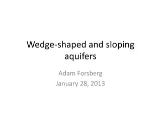
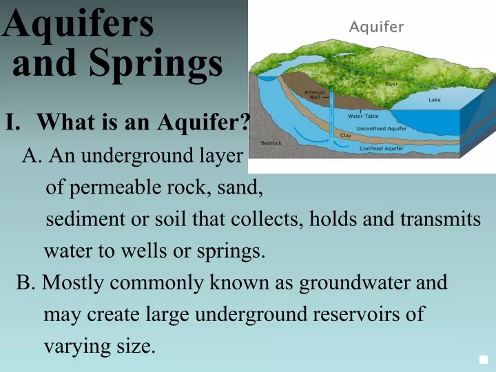
Aquifers and Springs. What is an Aquifer? A. An underground layer of permeable rock, sand, sediment or soil that collects, holds and transmits water to wells or springs. B. Mostly commonly known as groundwater and

E N D
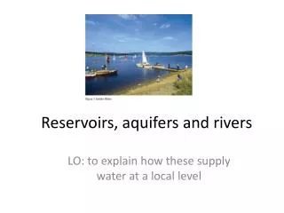
Aquifers and Springs • What is an Aquifer? • A. An underground layer • of permeable rock, sand, • sediment or soil that collects, holds and transmits • water to wells or springs. • B. Mostly commonly known as groundwater and • may create large underground reservoirs of • varying size.
II. Springs A. Develop when groundwater reaches the surface, which in turn can develops headwaters giving rise to streams and rivers. B. Form along fault lines (earthquakes). The Balcones fault exposed the Edwards Aquifer. C. More than 3000 springs in Texas.
D. Releases water into lakes and rivers when water tables reach the surface. E. Wetlands develop when water tables remain high, but vanish as levels drop below the surface.
F. The recharge zone is the area where water enters the aquifer. G. Water enters the aquifer through faults, fractures, sinkholes, or percolation through the soil. This process is called recharge. H. Limestone is on the surface on the recharge zone.
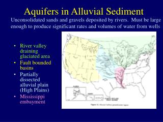
III. Texas Aquifers A. Nine Major Aquifers lie below Texas’ land. 1. Contains large amounts of water spread across large area. 2. Supplies 60% of water used for agricultural crop irrigation 3. 80% of irrigation water used comes from the Ogallala Aquifer, the largest in the U.S. a. Stretches from South Dakota through the Texas panhandle. b. Lies under the Texas High Plains region. c. Averages 95 feet in thickness. d. Formed about 2 to 6 million years ago
4. New water can move through the aquifers within a matter of hours flowing through the limestone and marble rock below. B. 21 Minor Aquifers contain smaller amounts of water spread over large areas or large amounts of water spread over small areas.
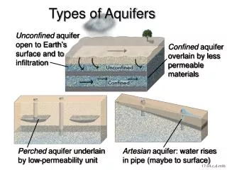
IV. Major Types of Aquifers • Unconfined aquifer (most common) • 1. Directly connected to the surface • 2. Ground water flows to the surface when the • water table (upper saturated layer) rises to the • level of the land. • 3. Water levels dependent on constant recharge • from rain on the wetlands surface. • 4. Playa lakes collect 95 % of recharge water. • a. Naturally occurring wetland formed when • rain fills small depressions in the prairie • b. 20,000 in the Texas High Plains
Unconfined Aquifer Stream Well Zone of Aeration Water Table Zone of Saturation
Recap: Water seeps through porous materials near the surface, but is trapped by impermeable rock below
Confined Aquifers • 1. Saturated layers of pervious rock sandwiched between • layers of impervious rock layers. • 2. The impervious layers squeeze the groundwater, • pressurizing it, giving rise to artesian wells. • 3. Artesian wells feed many Texas springs like the • San Solomon Springs in West Texas. • 4. Wells drilled in some confined aquifers may not need a • pump due to the amount of pressure forcing • groundwater to the surface. FACT: Great Artesian BasinThe world's largest known aquifer is the Great Artesian Basin, in Australia, at more than 1.7 million square kilometers (661,000 square miles).
Water Table Well Confined Aquifer Artesian Well Flowing Well Potentiometric Surface Aquifer Confining Layer Bedrock
http://www.edwardsaquifer.net/media/san_felipe_springs.mp4 http://www.edwardsaquifer.net/media/comal_springs.mp4 Salado Springs
Recap: Impermeable rock above and below. Rock strata must bend and outcrop at surface for rain to recharge porous material in between. Water will pressurize if higher than well heads – artesian system
C. Karst: a special type that occurs in limestone rocks when a system of caves is connected and water is flowing through it. –Edwards Aquifer 1. Develops in thick limestone formations, usually in humid climates. Karst has both surface and subsurface features. http://www.watersheds.org/earth/Sinkholes.html
2. Water naturally goes underground through sinkholes to caves (solution caverns). 3. Rainwater is slightly acidic and dissolves limestone rock to calcium carbonate & carries it away (dissolution). 4. Causes stalactite, stalagmite, & pillar formations in caverns
5. Caves Associated with the Edwards Aquifer Inner Space Cavern Austin, TX Kickapoo Caverns State Park Brackettville, TX Devil’s Sinkhole State Natural Area Rocksprings, TX Natural Bridge Caverns Natural Bridge Caverns, TX
VII. Ecosystems A. Most aquifers do not support traditional aquatic ecosystems. 1. No light, no photosynthesis (for plants) 2. No nutrients 3. No dissolved O2 to support aerobic life. 4. Survivors include: bacteria, protozoans, and other unicellular organisms. B. Karst aquifers support a more complex aquatic ecosystem in underground cave habitats. 1. Invertebrates, fish and amphibians make up the majority of the organisms.
2. Nutrients are recycled among the organisms • due to the lack of producers. • 3. Have a very low carrying capacity. • 4. Adaptations • a. Absence of eyes • b. Many devoid of color • c. Increased sensory development including, • antennae, chemoreceptors and touch • receptors. • d. Consistent water temperature supports a • lower metabolism which means less food • require. • e. Environment stable and predictable.
C. Nutrient Support from the outside 1. Cave-dwellers are depend on the plant and animal material washed into the caves. 2. Feces dropping from bats and mice provides nutrients for fungal growth which many insects eat. 3. Food chain: Fungi insects insect larva invertebrates blind salamander toothless blindcat (catfish). Death of the catfish would provide nutrients and cycle continues
D. Spring Ecosystems 1. Food provided by aquatic plants and algae 2. Isolated habitats of many springs contain species found only in that particular location. 3. Consistent water temperatures near the springs the cave openings prevent organisms from wandering to the streams and rivers associated with the spring. 4. Ecosystems are small providing limited numbers of any one species population to survive.
E. Changes Impact the Habitat 1. Decrease in ground water flow or drought reduces habitat and stresses many species. 2. Invasive species enter native springs and take over often eliminating the indigenous species of the spring. 3. Human impact on springs vary; from building dams across the springs to building recreations pools destroying the native species.
V. Water Supply Problems for Aquifers and Springs A. Water Supply Problems 1. Water Quantity a. Spring runoff is highly dependent on rainfall b. Not enough recharge times between drought c. Edwards aquifer holds a huge amount of water but: At less than 95% capacity, the springs run dry. d Endemic fauna and flora inhabit springs and caves and are vulnerable to extinction if water levels get too low.
2. Water Quality - a. Vulnerable because aquifer is relatively shallow b. Little reaction time in case of a spill c. Clean-up of local threats almost impossible Aquifer has a low self-cleaning ability (natural remediation)http://www.watersheds.org/earth/karstmovie.htm
3. Sources of Pollution –a. Solid waste 1. Wild depositions in dolines (sink-holes) are common in many area 2. Strong precautions for sealing dump-sites b. Waste water 1. high risk from leaking sewers 2. used water infiltrates aquifer 3. no surface drainage system c. Agricultural use d. Industrial contamination e. Hydrocarbons-explosive f. Liquid waste injection
VI. Environmental ImpactA.Eight species in the Edwards Aquifer, Comal Springs, and San Marcos Springs ecosystems are currently listed by the U.S. Department of Interior, Fish and Wildlife Service, as either threatened or endangered species. EndangeredComal Springs Dryopid Beetle Comal Springs Riffle BeetleFountain Darter Peck’s Cave AmphipodSan Marcos GambusiaTexas Blind SalamanderTexas wild-riceThreatenedSan Marcos Salamander