Download
1 / 1
10 likes | 74 Views
Improving Severe Weather Forecasting: Hyperspectral IR Data and Low-level Inversions. June 07, 2005 Case Study. Future Work. Justin M. Sieglaff Cooperative Institute for Meteorological Satellite Studies (CIMSS) Department of Atmospheric and Oceanic Sciences University of Wisconsin - Madison

E N D
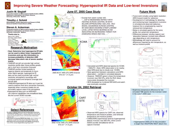
Improving Severe Weather Forecasting: Hyperspectral IR Data and Low-level Inversions June 07, 2005 Case Study Future Work Justin M. Sieglaff Cooperative Institute for Meteorological Satellite Studies (CIMSS) Department of Atmospheric and Oceanic Sciences University of Wisconsin - Madison Timothy J. Schmit NOAA/NESDIS, SaTellite Applications and Research (STAR) Advanced Satellite Products Branch (ASPB) Steven A. Ackerman Cooperative Institute for Meteorological Satellite Studies (CIMSS) Department of Atmospheric and Oceanic Sciences University of Wisconsin - Madison • Future work includes using higher resolution • AIRS forward model for radiances • Development of methodology for detecting • and monitoring lower tropospheric inversions • in simulated and observed radiances, • however this is complicated by need for • retrieved skin temperature • Below is simulated spectra for the same • profile, but varied skin temperature • Differences between ‘window regions’ and • ‘absorption features’ (circled) have different • sign depending on skin temperature • Methodology will need to account for • differences imparted by skin temperature, as • well as moisture profile • Excerpt from watch number 425: • “…CAP IS WEAKENING RAPIDLY WITH • HEATING ACROSS CENTRAL WI WITH • MLCAPE APPROACHING 1000 J/KG. RUC • MODEL SOUNDINGS ACROSS CENTRAL • WI HAVE BEEN SHOWING STEEP LOW/MID • LEVEL LAPSE RATES NEARING 8C/KM • INDICATING AN INCREASING THREAT FOR • DAMAGING WINDS AND HAIL. …” Thanks also to… Wayne Feltz, CIMSS Bob Rabin, NSSL/CIMSS Jun Li, CIMSS Jinglong Li, CIMSS Michael Morgan, UW Jim Nelson, CIMSS Gene Brusky, NWSFO GRB KCWA Research Motivation • Goal: Determine how hyperspectral IR data • can be used to detect lower tropospheric • inversions and use this information to • increase probability of detection AND • decrease false alarm rate of severe weather • events • TAMDAR aircraft can provide high vertical • resolution profile data; these profiles greatly • aid in short term convection forecasts • TAMDAR profiles limited spatially to • regional airports and temporally to hours • when flights operate; hyperspectral IR • data can be used to provide high vertical • resolution atmospheric soundings with • increased spatial and temporal coverage over • aircraft data • TAMDAR/Hyperspectral IR data can in part be • used to improve short term convection forecasts, • especially when numerical models do not • accurately capture state of the atmosphere • Hyperspectral data such as AIRS/HES • can improve capabilities over broadband data, • like the current GOES sounder • Calculated and AIRS observed spectra for KCWA • ~1900UTC (Note: AIRS observation is for nearby • clear AIRS pixel due to clouds over KCWA) • Note agreement between calculations and AIRS • observation – confident in simulated datasets • However, TAMDAR (green) shows the temperature • inversion near 900 hPa, while the RUC (blue) • inaccurately dissipated the inversion • MCS dissipated as it entered WW #425 and watch • was eventually cancelled 2005 06 07 1850 UTC AIRS Granule 872 cm-1 (11.5 µm) October 04, 2002 Retrieval • Brightness temperature difference for two • simulated TBB spectra for the inversion noted • in the June 7,2005 case GOES-12 B6 286.9 K GOES-12 B8 294.4K GOES-12 B7 291.7K CART SITE Select References • Observed AIRS spectra for CART site, observed • temperature and moisture profiles, and retrieved • temperature and moisture profiles • CIMSS/AIRS experimental retrieval (hyperspectral) • detects inversion near 850 hPa, while current • GOES sounder (broadband) fails to • capture inversion The Utility of TAMDAR Regional Aircraft Sounding Data in Short-term Convective Forecasting, Eugene S. Brusky, NOAA/NWS, Green Bay, WI; and P. Kurimski, 10th Symposium on Integrated Observing and Assimilation Systems for the Atmosphere, Oceans, and Land Surface (IOAS-AOLS), February 2006 AirDat System for Ensuring TAMDAR Data Quality, Alan K. Anderson, 10th Symposium on Integrated Observing and Assimilation Systems for the Atmosphere, Oceans, and Land Surface (IOAS-AOLS), February 2006 AIRS Subpixel Cloud Characterization Using MODIS Cloud Products, Jun Li, Et. Al., Journal of Applied Meteorology, August 2004 • Hyperspectral (HES) ΔT for this simulation • is larger than HES/PORD NEDT (black line) 2002 10 04 1945 UTC AIRS Granule 872 cm-1 (11.5 µm)