Download
1 / 1
10 likes | 126 Views
COMPARATIVE ANALYSIS OF LIVELIHOOD STRATEGIES ACROSS SITES INVOLVED IN THE SANREM PROJECT IN THE ALTIPLANO C. Turin 1,2 , J. Thomas 1 y J. Gilles 1 1 College of Agriculture, Food and Natural Resources, University of Missouri, Columbia, MO 65211 USA

E N D
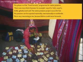
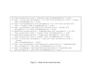
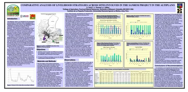
COMPARATIVE ANALYSIS OF LIVELIHOOD STRATEGIES ACROSS SITES INVOLVED IN THE SANREM PROJECT IN THE ALTIPLANO C. Turin1,2, J. Thomas1 y J. Gilles1 1College of Agriculture, Food and Natural Resources, University of Missouri, Columbia, MO 65211 USA Instituto de La Pequeña Producción, Universidad Nacional Agraria La Molina, Lima, Peru • Circa, Vinto Coopani, and Kellhuiri are situated in the district of Umala. Both districts belong to the department of La Paz. • The objective of the questionnaire administered in Bolivia was to collect information about the activities that are part of agricultural and livestock production. The questionnaire consisted of seven sections focusing on different topics: demographic information; agricultural production; livestock production; product commercialization; biodiversity; food consumption; and, perception of risk. • The focus of the questionnaire in Perú was on understanding how decisions are made as part of a livelihood strategy, particularly as they are based in relationships between local knowledge and practice. • In Perú, the questionnaire also consisted of seven sections: demographic information; animals; grasslands and pastures; climate; markets; organizations; and, food security. The questionnaire was administered in 119 households of rural families. These households are located in two communities, each in a different district. Santa María is part of the district of Ilave, and Apopata is in the district of Mazocruz in the department of Puno. • The use of different questionnaires across sites produced data sets with distinct variables. The challenge in this work was to combine information across sites to produce a new data set containing new variables to be used in quantitative analysis. • The result is a data set that includes 40 variables, which become the focus of the following analysis and description livelihoods. The tables, charts, and graphs in this poster present some preliminary findings. • management. The proportions of households using various periods of time for fallow vary considerably throughout the communities. In part, we see that a large portion of families rest their land for less than one year. In San José Llanga and Santa María, families most frequently report fallow periods of two to four years. The graph also shows a greater variance in practice within particular communities, i.e., Vinto Coopani and Kellhuiri. • In Table 1, we see different levels of access to natural capital as we look at the size of land holdings of households. There are communities that report average land holdings of less than one hectare while others have an average greater than ten hectares. • Generally, cattle are an important asset for all of the communities. However, the cases of San José Llanga and San Juan Circa present the highest numbers of cattle per family, 5.9 and 6.8 respectively. • Generally, sheep are an important asset for all of the communities. However, the cases of Chojñapata, Kellhuiri, and Apopata present the highest numbers of sheep per family, 38, 41, and 35.9 respectively. • In Table 1, the raising of South Americna camelids appears to be of relative important in certain communities, especially Chojñapata and Apopata, the two communities that present the highest average number of animals per family, 27.9 and 69.1 respectively. • Generally, both the head of the household and spouse have access to primary education. However, the head of the household has greater access to secondary education in all of the communities. Further, the level of Spanish language ability reported for the head of the household is higher than that of the spouse. • The households in all eleven communities consult neighbors and family members within the same community to acquire information about markets. Figure 5. Labor. Percentage of families that report using three types of labor. Figure 3. Income from Agricultural Activities. Percentage of families reporting the three primary sources of income for agricultural activities. Introduction The Altiplano region, as classified by its geographic characteristics of a plateau within mountains at an elevated altitude it the scene of the SANREM Project “Adaptation to Climate Change and Markets of Vulnerable Agricultural Ecosystems of the Altiplano.” The importance of the Altiplano is found in a culture at the center of the domestication and transformation of important resources in agriculture such as the potato, quinoa, and South American camelids, as well as a place of development in technology for adaptation to climate change. The goals of this project are to promote a shared understanding of the ecosystem, the development of livelihood strategies, and the management of natural resources based on the perceptions of change and risk. This shared understanding is being developed through the study of local knowledge and practices, and comparing learning across global knowledge to increase resilience in systems of income generation and food security of local actors. The focus on activities allows for an evaluation of diverse livelihoods strategies of rural families with respect to the social, economic, political, and environmental conditions. In adverse ecosystems like the Altiplano, adaptation and diversification of strategies has become a key factor for survival. The following presentation identifies the current livelihood strategies of eleven Aymara communities in the Altiplano of Bolivia and Peru. The objective is to understand how these strategies have developed and adapted according to the conditions present. This analytical exploration was conducted through analysis of data sets compiled from surveys conducted in both countries. Figure 4. Other Sources of Income. Percentage of families reporting the three primary sources of income for non-agricultural activities. Figure 6. Land in Fallow. Number of families that report having fallow land for various periods of time. Figure 2. Location of SANREM study sites in the Altiplano of Perú and Bolivia. Objectives • Identify common points and differences among the strategies, capitals, and practices found in the different sites involved in the project. • Compare livelihood strategies across the eleven communities in Bolivia and Peru. Observations Materials and Methods • In Figure 3, we observe the importance of the sale of animals as a source of income in the communities. The sale of agricultural products and the sale of animal products are more varied in importance, with Cohani and Apopata being cases of special importance in the sale of animal products and agricultural products respectively. • Figure 4 shows other sources of income that are important to households in these communities, especially work outside the community and remittances. The sale of handicrafts is also a source of income for households in some communities. • In Figure 5, we can see that family members are involved as labor in the activities in most of the households of all the communities. The quantity of hired labor and labor shared with neighbors is more varied when compared across communities. • Figure 6 shows the proportional use of different periods of time for fallow in household land • The first stage of the project involved the exchange of information and data collection through questionnaires, workshops, and interviews. The second stage is the analysis of information. The third stage is the devolution and incorporation of information into the livelihood practices of local actors • During the first stage of the project, 2006 – 2007, databases were compiled with information collected using two questionnaires. • As part of the initial data collection process, a questionnaire was administered in a total of 330 households from nine communities in Bolivia. The communities taking part in this project are located in two municipalities, or districts. The district of Ancoraimes comprises Chojñapata, Calanhauancani, Cohani, Karcapata, and Chinchaya, while San José Llanga, San Juan Conclusions & Recommendations In conclusion, we recognize the importance of land, labor, and animals to varying degrees across the communities involved with this SANREM project. Among the preliminary findings we are able to identify a diversity of activities involved in the development of livelihood strategies in the Altiplano. Further analysis will benefit from more detailed information about the quality of land and animals in each location, as well as information about decisions that affect the use of land, particularly with regard to the use of the fallow period, and the use of family, shared, and hired labor. By addressing these and other areas in a comprehensive manner, future analysis can assess the adaptation of livelihoods and diversification as a strategy within each community and the Altiplano. Table 1. Summary of Natural, Human, and Social Capital in Communities. Figure 1. Transect of the study sites according to altitude.