Download
1 / 41
410 likes | 495 Views
Bio 126 Climate and Weather. Earth from the moon. Meteorology. Climate- over all combination of temperature and precipitation that a region experiences Mediterranean= winter precipitation followed by long hot, dry summers Weather- daily, weekly variations in these phenomena.

E N D
Meteorology • Climate- over all combination of temperature and precipitation that a region experiences • Mediterranean= winter precipitation followed by long hot, dry summers • Weather- daily, weekly variations in these phenomena
Climate zones • Warm at equator, cooler towards poles. • Caused by intensity of sunlight at equator. • Poles receive less on a per area basis.
Solar radiation around the Globe Solar radiation around the Globe
Seasons • Caused by tilting of earth on its rotational axis. • Intensity of sunlight varies. • Most extreme at poles • Little change at equator.
Precipitation • Varies by latitude. • Wet at equator 00, and 600 N / S • Dry at 300, and 900 poles • Poles are frozen deserts • Caused by formation of Hadley Cells
Hadley Cells • Air currents in Hadley Cells caused by air density not just temperature. • Uneven heating in different regions on the earth cause winds.
Hadley Cells • Air rises (0, 60) due to warming of surface. • Adiabatic Cooling as air rises • as rises the air becomes less dense and cooler • this cause water to condense and fall as rain, snow • Air falls (30, poles) • Adiabatic warming as air falls • air becomes compressed, and heats. • air absorbs moisture, falls as dry air and absorbs moisture from the environment.
Global air circulation, precipitation, and winds: Hadley cells
West Coast Latitudes • San Diego=32.5; LA= 34; Sta. Barbara= 34.5 ; Sta. Cruz=37, SF 37.75; Eureka= 40.75 • Approx. Portland= 45.5; Seattle= 47.5 ; Juneau= 58; Anchorage = 61 • CA large enough to span climate zones between Hadley cells. • South dry • North wet
Seasons- • tilting of earth moves solar equator. • Effectively moves 300 dry zone north in summer • descending dry air belt is pushed farther north in our summer, • the wet belt moves farther south giving us wet winters
Prevailing winds • These Hadley cell wind currents move North or South • The spinning of the earth makes it seem like they come at an angle. • In CA our winds, storms usually come from the south west. • Rains often bring warmer weather
Ocean currents • Prevailing winds cause ocean waters to move in the prevailing direction. • huge gyres form due to earth’s spinning known as the Coriolus effect • In Northern Pacific clockwise general direction of flow from our coast. • Ca. Current, with its cold, nutrient rich water flows from Alaska southwards along our coast • At Sta. Barbara coastline moves east, current flows due south, allowing Southern Ca. water to warm
Barometer measures air pressure • Low pressure (rising air) associated with storms. • High pressure (descending air) blocks storms. • High pressure off California in summer blocks most storms
Biomes • Major vegetation types that also determine the animal community present. • Determined mostly by climate • Soil also important factor
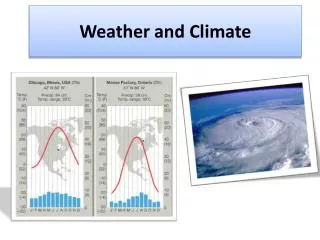
Figure 50.3 A climograph for some major kinds of ecosystems (biomes) in North America
Coniferous forest, Lady Bird Grove (top left), Sequoias (right), rain forest (bottom left)
Temperate deciduous forest, Great Smokey Mountains National Park
Desert. Organ Pipe State Park (top), Joshua Tree National Park (bottom left), Death Valley (bottom right)
Rain shadow • Precipitation increases as storms are pushed up over mountians. • accordingly rain becomes snow • As air moves up slope in the Sierras it cools 3-5 degrees per 1,000 ft. • This is the same effect as moving 300 miles farther north ! • Causes deserts in Nevada • Most islands with mountains have wet and dry sides
Summer Fog • Inland air warms quickly. This rising air, pulls in coastal air. • Cold water off CA. cools incoming warm, moist ocean • Coast causes summer fog. • Essential for southern ranges of Coast Redwoods, and relic pines, cypress species
Temperature Inversion layers • dense air flows downhill and collects in low spots, valleys. Great Central valley is an example. • This dense air may be blocked by hills etc. from warmer winds which blow over the top of dense air, leaving it alone. • Dense tule fog may form for days. • Inversion layer (cold air higher up) also traps pollutants. • Mexico City problems • Reno, Tahoe now ban fireplaces. • Often “burn off” in summer but leave the haze of phytochemical smog behind.