Download
1 / 18
180 likes | 311 Views
UNITS 5&6: AERIAL & SATELLITE IMAGES AND GLOBAL POSITIONING SYSTEM (GPS ). UNITS 5: GLOBAL POSITIONING SYSTEM (GPS ). Remotely-Sensed Images. What is Remote Sensing? Techniques for collecting and classifying information about objects on Earth’s surface without physical contact

E N D
UNITS 5&6:AERIAL & SATELLITE IMAGES AND GLOBAL POSITIONING SYSTEM (GPS)
Remotely-Sensed Images What is Remote Sensing? • Techniques for collecting and classifying information about objects on Earth’s surface without physical contact What are Remotely-Sensed Images? • Aerial photos and satellite images are examples of Remotely-Sensed Images or Remotely-Sensed Data • They are images produced by aerial cameras and satellite scanners
Remotely-Sensed Images Uses (Positive Attributes): 1. Large Area Coverage: • Cheaper and faster than ground survey 2. Extended Spectral Range: • Detect features not visible to the eyes
Remotely-Sensed Images Uses (Positive Attributes): 3. Geometric Accuracy: • Can be converted to accurate spatial data—after distortions are removed 4. Permanent Record: • Provide historical (time-series) spatial data—for monitoring and other uses
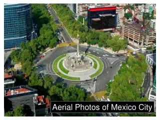
Aerial Photographs Aerial Photographs: • images taken from airborne (aeroplane-mounted) cameras Photogrammetry: • the science of using photography to ascertain geometric measurements in surveying and mapping
Aerial Photographs Uses of Aerial Photographs in GIS: 1. Surveying and mapping 2. Assigning attributes to features (spatial objects) 3. Photographs serving as background layers for maps of other features • E.g. road map with aerial photo as background
Aerial Photographs Distortions in Aerial Photographs : • For mapping purposes, what do you think are the main distortions in aerial photographs? • Most aerial photographs provide Perspective Views but most maps are based on Orthographic Views • Perspective = tilted view • Orthographic = vertical view
Aerial Photographs Sources of Distortions in Aerial Photos: • Terrain • Camera tilt • Atmospheric bending (weather) • Film deformation (defects) • Camera lens defects • Other camera errors
Satellite Images • Taken by satellite-mounted scanners (not photographic cameras) • Taken at higher altitude than aerial photos • Less terrain and tilt distortions • But can be more expensive to obtain, especially over very small study areas
Global Positioning System (GPS) What is Global Positioning System (GPS)? • A satellite-based technology designed to positional information anywhere anytime on Earth’s surface
Global Positioning System (GPS) Some GPS systems: • NAVSTAR—most popular and operated by U.S. Dept. of Defence • GLONASS—a Russian system used mainly the former Soviet block • Compass—a Chinese system • Galileo—a European system (to be operational by 2019)
Global Positioning System (GPS) Main Components 1. Satellite segment: • a constellation of satellites orbiting the earth 2. Control Segment: • control stations on Earth consisting of tracking, communication (receiving and transmission), data gathering, integration, analysis and control facilities 3. User Segment: • GPS receivers at the user end
GPS Applications Most Common GPS Applications: • Navigation—for directions • Tracking • Field Digitizing • Surveying