Download
1 / 13
130 likes | 135 Views
Sensor Classification System Canadian Version: Siting Classification. Rodica Nitu. Sensor Classification System: “ Canadian Version”.

E N D
Sensor Classification System Canadian Version: Siting Classification Rodica Nitu
Sensor Classification System: “Canadian Version” • To ensure international consistency, at this time the ‘Maintained Performance’ portion of the Sensor Classification System (A-E) is awaiting international input. • The Sensor Classification System is to be applied to ‘existing’ sites. The Meteo-France version works well when applied to ‘green field’ sites but omits many siting bias potentials when applied to an existing network. • The ‘Sensor Siting’ portion (1-5) of the system required a ‘Canadianized’ version and is actively being proposed for use. The Maintained Performance can easily be added later and will not require additional field trips. • Canadian version can be used to assess both existing and green field sites with the green field classification re-assessed before data is released.
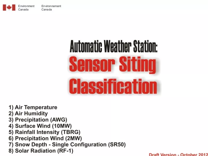
System Implementation Overview 1 • With consideration to the many different networks and sensors gathering data across Canada, both manual and automated for a single parameter type, it would be far too cumbersome to include them all into a single classification assessment document. • For simplicity, the Canadian version will initially focus on the MSC sensor suite approved for reference and supplimental autostations (RCS/SWX) . • Classification system has been expanded to include 8 automated sensor parameters (pressure sensor on hold). Only a single classification is required for solar radiation. • Additional future documents will be put together to include other network sensors (ie. manual, alternate auto sensors, etc.) for comparable classification results. • For system sustainability and continual classification updates, it must be applied by the routine site technician. To be applied by a ‘specialist’ would not be sustainable in a timely fashion with regards to siting changes over time.
System Implementation Overview 2 • As much as possible, the basic criteria listed in the Meteo-France version has been preserved and further expanded upon. • Since assessments are to be done by routine technical staff, subjectiveness had to be reduced and clarification added to ensure homogenous results across the country. This resulted in an increase in the document size. • As an archive to note future changes, avoidance of classification level flip-flopping and to supply a document both for supervisors and data users, simple ‘result’ forms are a requirement to be filled in. • A full classification assessment is to be done every 5 years to coincide with established meta-data updates (photos, drawings, etc.) where the forms are completed and archived. • Single sensor classification updates are completed and archived anytime a change in classification level is confirmed. It can be ‘back dated’ if known.
System Implementation Overview 3 • A numbering system has been added to identify each classification criteria so that it can easily be identified on the assessment archive form. A single page is utilized for each parameter or sensor. • With use of detailed site knowledge, good meta-data, drawings, photos, area maps, graphics programs and Google Earth, a full siting classification can be done without a field trip for many sites. • If an assessment or measurement for a specific criteria is between class levels, the numerically higher number is used. • The classification system has been worded to ensure that terminology does not refer to a siting range of “good to poor”. Rather, the 1-5 range refers to “area of representativeness”. This is to not offend the inclusion of other agencies with specific siting requirements to use this system.
Example Temp Class1 criteria:
Example Archive Form:
Siting Classification variations from Meteo-France 1 • Temperature and Humidity have been separated into distinct classifications. Although identical for siting criteria, this is necessary since they may often have different ‘Maintained Performance’ results. • The Tipping Bucket Rain Gauge has its own classification as ‘Rainfall Intensity’ and is not considered as a ‘Precipitation All Weather Gauge’. Each can have Class 1 siting for its own intended purpose. • The surface heating influence distance radius rings have been altered to remove the ‘annulus’ area for simplicity of assessment. • Surface Wind height has a criteria of 10 meters +/- 1m. This is required for intercomparison purposes. • The ‘Precipitation Wind’ sensor (formerly 2 Meter Wind) has its own classification since its purpose should not be included with the 10 Meter Surface Wind classification.
Siting Classification variations from Meteo-France 2 • Bias onto Temperature and Humidity sensors caused by local infrastructure (ie. electrical boxes, mounting structures, etc.) need to be subjectively included as criteria. • Precipitation AWG needs is own siting classification from other ‘liquid precipitation only’ sensors due to considerable siting and height differences. • Double Shielded on a Precipitation AWG (ie. DFIR) is a requirement for Class 1. • The use of a ‘wind shield’ is a requirement for Precipitation AWG classes 2, 3 and 4 to differentiate from ‘unshielded’.
Siting Classification variations from Meteo-France 3 • Optimum distance, height and influences for the Precipitation Wind and Snow Depth sensors needed to be assumed where established standards do not exist. • Influences from nearby aircraft movement, area snow removal methods and nearby ground cover irrigation need consideration. • A specified minimal amount of mid-day shading onto the temperature and humidity enclosure is assessed for each class level. • Additional detail has been supplied to assess the amount of level area surrounding sensors to lessen assessment subjectiveness .
Siting Classification variations from Meteo-France 4 • Wherever height/distance requirements such as 2:1, 4:1, 10:1. etc. are used, angle measurements are supplied to assist the technician with a scope. • Where it is needed to measure a percentage of a ringed area for surface heating, these percentages are also given as square meters and square footage to assist assessment. • The term ‘effective height’ is used to explain the horizontal measurement point reference (ie. above the precipitation sensor rim, from eye height at the base of the wind tower, etc.). • To surround a precipitation sensor with trees as a natural DFIR, to be more realistic, its criteria is to surround by a minimum of 300 degrees. • Even if only a seasonal occurrence (not necessarily at the time of assessment) of a water collection area, it is still considered as an expanse of water.
Siting Classification variations from Meteo-France 5 • Wherever height/distance requirements such as 2:1, 4:1, 10:1. etc. are used, angle measurements are given to assist the technician with a scope. • The height of anticipated maximum snow depth is a classification criteria for Temperature, Humidity and Precipitation AWG. • The assessments can be done at any time but are generally considered as taking place in mid-summer due to some seasonal bias variability; • Changing tree foliage affecting shade/wind/precipitation • Snow pack and harvesting affecting wind ground friction index • Height of wind sensors changing with increasing snow pack level