Download
1 / 1
10 likes | 121 Views
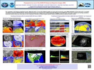
Remote sensing of aerosol from the GOES-R Advanced Baseline Imager (ABI) Istvan Laszlo 1 , Pubu Ciren 2 , Hongqing Liu 2 , Shobha Kondragunta 1 , Xuepeng Zhao 3 , J. Dan Tarpley 1 and Mitch Goldberg 1 1 Center for Satellite Applications and Research , NOAA/NESDIS, Camp Springs, Maryland

E N D
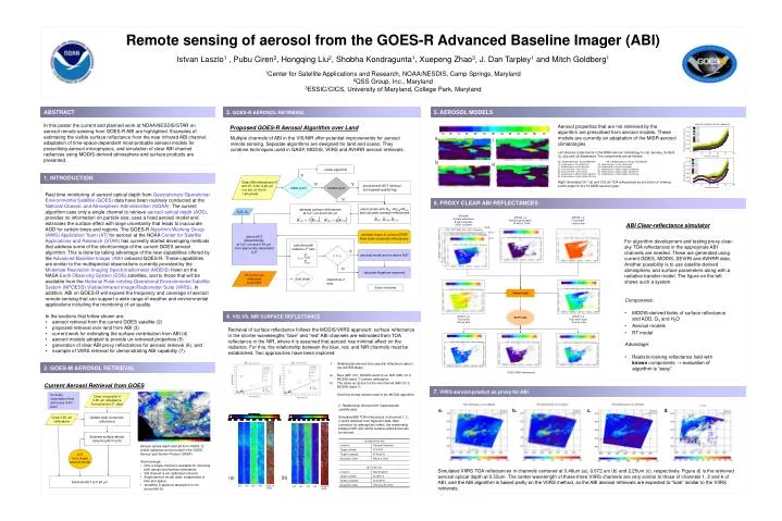
Remote sensing of aerosol from the GOES-R Advanced Baseline Imager (ABI) Istvan Laszlo1 , Pubu Ciren2, Hongqing Liu2, Shobha Kondragunta1, Xuepeng Zhao3, J. Dan Tarpley1 and Mitch Goldberg1 1Center for Satellite Applications and Research, NOAA/NESDIS, Camp Springs, Maryland 2QSS Group, Inc., Maryland 3ESSIC/CICS, University of Maryland, College Park, Maryland 1a 1b 1c 2a 2b 3a 3b 4a 4b 4c 5a 5b 5c a c MYD09A Surface reflectance 8 day-composite 500m by 500m MYD04_L2 Aerosol optical depth 10 km by 10 km MYD35_L2 Cloud mask 1 km by 1km Ch 6 b Ch 2 d Ch 1 ocean algorithm Y Clear ABI reflectances R at 0.47, 0.64, 2.26 m in a box of 10x10 1-km pixels water pixel coastal pixel N Y proceed with AOT retrieval but degrade quality flag for every observation time and every 4-km pixel Clear composite of 0.65 m reflectance from previous 21 days Update clear composite reflectance Clear 0.65 m reflectance N Estimate surface albedo assuming AOT=0.02 estimate surface reflectances at 0.47 m and 0.64 m select pixels with Rmin ≤R2.26≤Rmax and calculate average reflectances H2O, O3 Common grid LUT for a single aerosol model derive AOT independently at 0.47 m and 0.64 m from space-time dependent LUT Estimate AOT at 0.65 m estimate shape of surface BRDF from clear-composite reflectances 6S RT code MYD07_L2 Total ozone 5km by 5km MYD07_L2 Total water vapor 5 km by 5 km calculate path radiance L0 ratio r > rt Y use dust model and re-derive AOT N calculate Angstrom exponent 10.9-12.2 m radiances from HES dust slope Determine if dust future modules GOES-R ABI reflectances (a) (b) (a) (b) ch1 ch2 ch3 ch6 50:32:10 (RGB) ch1 ch2 ch3 ch6 109:30:15 (RGB) ABSTRACT 3. GOES-R AEROSOL RETRIEVAL 5. AEROSOL MODELS In this poster the current and planned work at NOAA/NESDIS/STAR on aerosol remote sensing from GOES-R ABI are highlighted. Examples of estimating the visible surface reflectance from the near infrared ABI channel, adaptation of time-space-dependent most-probable aerosol models for prescribing aerosol microphysics, and simulation of clear ABI channel radiances using MODIS-derived atmosphere and surface products are presented. Aerosol properties that are not retrieved by the algorithm are prescribed from aerosol models. These models are currently an adaptation of the MISR aerosol climatologies. Left: Aerosol components in the MISR aerosol climatology for (a) January, (b) April (c) July and (d) September. The components are as follows: 1a. Carbonaceous+ Dusty Maritime 4a. Carbonaceous+ Dusty Continental 1b. Carbonaceous+ Dusty Maritime 4b. Carbonaceous+ Dusty Continental 1c. Carbonaceous+ Dusty Maritime 4c. Carbonaceous+ Dusty Continental 2a. Dusty maritime+ Coarse Dust 5a. Carbonaceous+ Black Carbon Continental 2b. Dusty maritime+ Coarse Dust 5b. Carbonaceous+ Black Carbon Continental 3a. Carbonaceous+ Black Carbon Maritime 5c. Carbonaceous+ Black Carbon Continental 3b. Carbonaceous+ Black Carbon Maritime Right: Simulated Ch1 (a) and Ch2 (b) TOA reflectances as a function of viewing zenith angle for the 13 MISR aerosol types. Proposed GOES-R Aerosol Algorithm over Land Multiple channels of ABI in the VIS/NIR offer potential improvements for aerosol remote sensing. Separate algorithms are designed for land and ocean. They combine techniques used in GASP, MODIS, VIIRS and AVHRR aerosol retrievals. 1. INTRODUCTION • Real time monitoring of aerosol optical depth from Geostationary Operational Environmental Satellite (GOES) data have been routinely conducted at the National Oceanic and Atmospheric Administration (NOAA). The current algorithm uses only a single channel to retrieve aerosol optical depth (AOD), provides no information on particle size, uses a fixed aerosol model and estimates the surface effect with large uncertainty that leads to inaccurate AOD for certain times and regions. The GOES-R Algorithm Working Group (AWG) Application Team (AT) for aerosol at the NOAA Center for Satellite Applications and Research (STAR) has currently started developing methods that address some of the shortcomings of the current GOES aerosol algorithm. This is done by taking advantage of the new capabilities offered by the Advanced Baseline Imager (ABI) onboard GOES-R. These capabilities are similar to the multispectral observations currently provided by the Moderate Resolution Imaging Spectroradiometer (MODIS) flown on the NASA Earth Observing System (EOS) satellites, and to those that will be available from the National Polar-orbiting Operational Environmental Satellite System (NPOESS) Visible/Infrared Imager/Radiometer Suite (VIIRS). In addition, ABI on GOES-R will expand the frequency and coverage of aerosol remote sensing that can support a wide range of weather and environmental applications including the monitoring of air quality. • In the sections that follow shown are: • aerosol retrieval from the current GOES satellite (2) • proposed retrieval over land from ABI (3) • current work for estimating the surface contribution from ABI (4) • aerosol models adopted to provide un-retrieved properties (5) • generation of clear ABI proxy reflectances for aerosol retrieval (6), and • example of VIIRS retrieval for demonstrating ABI capability (7). 6. PROXY CLEAR ABI REFLECTANCES ABI Clear-reflectance simulator For algorithm development and testing proxy clear-sky TOA reflectances in the appropriate ABI channels are needed. These are generated using current GOES, MODIS, SEVIRI and AVHRR data. Another possibility is to use satellite-derived atmospheric and surface parameters along with a radiative transfer model. The figure on the left shows such a system. Components: • MODIS-derived fields of surface reflectance and AOD, O3 and H2O • Aerosol models • RT model Advantage: • Realistic-looking reflectance field with known components → evaluation of algorithm is “easy”. 4. VIS VS. NIR SURFACE REFLECTANCE Retrieval of surface reflectance follows the MODIS/VIIRS approach: surface reflectance in the shorter-wavelengths “blue” and “red” ABI channels are estimated from TOA reflectance in the NIR, where it is assumed that aerosol has minimal effect on the radiance. For this, the relationship between the blue, red, and NIR channels must be established. Two approaches have been explored: • Relationship derived from spectral reflectance data in the ASTER library: • Blue (ABI: Ch1, MODIS: band 3) vs. NIR (ABI: Ch 6, MODIS: band 7) surface reflectance. • The same as (a) but for the red channel (ABI: Ch 2, MODIS: band 1). • Solid line shows relation used in the MODIS algorithm. 2. GOES-M AEROSOL RETRIEVAL Current Aerosol Retrieval from GOES 7. VIIRS aerosol product as proxy for ABI 2. Relationship derived from hyperspectral satellite data: Simulated ABI TOA reflectances in channels 1, 2, 3 and 6 obtained from Hyperion data. After correction for atmospheric effect, the relationship between NIR and visible surface reflectances can be derived. a. b. c. d. Aerosol optical depth derived from GOES-12 visible radiances and provided in the GOES Aerosol and Smoke Product (GASP). • Shortcomings: • Only a single channel is available for retrieving both aerosol and surface reflectance. • VIS channel is not calibrated onboard. • Single aerosol model used, independent of time and space. • Variability in gaseous absorption is not accounted for. Simulated VIIRS TOA reflectances in channels centered at 0.48um (a), 0.672 um (b) and 2.25um (c), respectively. Figure d) is the retrieved aerosol optical depth at 0.55um. The center wavelength of these three VIIRS channels are very similar to those of channels 1, 2 and 6 of ABI, and the ABI algorithm is based partly on the VIIRS method, so the ABI aerosol retrievals are expected to “look” similar to the VIIRS retrievals.