Download
1 / 26
260 likes | 393 Views
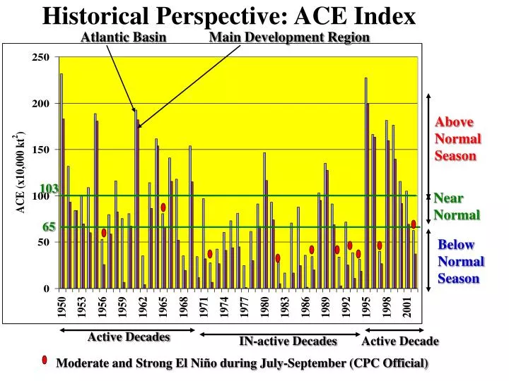
Atlantic Basin Main Development Region. Above Normal Season. 103. Near Normal. 65. Below Normal Season. Active Decades. Active Decade. IN-active Decades. Historical Perspective: ACE Index. Moderate and Strong El Niño during July-September (CPC Official).

E N D
Atlantic Basin Main Development Region Above Normal Season 103 Near Normal 65 Below Normal Season Active Decades Active Decade IN-active Decades Historical Perspective: ACE Index Moderate and Strong El Niño during July-September (CPC Official)
Tropical Cyclone Tracks: In-Active 1997 Atlantic Tracks for 1997 Main Development Region (MDR)
Tropical Cyclone Tracks: Active 1998 Atlantic Tracks for 1998 Main Development Region (MDR)
Most Recent Northeast Snowstorm 12Z, December 5, 2002
Forecast Skill for Selected Global Circulation Components AAO: Antarctic Oscillation PNA: Pacific North American Oscillation AO: Arctic Oscillation NAO: North Atlantic Oscillation
The View Ahead • Decision Systems will have weather – climate input • Predictive model will include all earth system components • Models will have to provide level of uncertainty – all forecasts will be ensemble-based
Methodology Framework • Sector Assessments and Multi-sector Overview • Develop understanding needed for next steps • Set research priorities (natural, social, policy) • Development and Evolution of In-depth Programs • Estimate value of various forecasts • Identify opportunities: prototypes/full systems • Implementation of In-depth Programs • Realize opportunities, e.g., fog forecasting, 2-day temperature forecasts, electricity transmission system needs, QPF, etc. • Demonstrate and document prototype solutions From Tim Killeen NCAR Director
Dutton, J.A., 2002: Opportunities and priorities in a new era for weather and climate services. Bull. Amer. Meteor. Soc.,83, 1303-1311.
Earth System Modeling Framework Rollout DAO fvCAM 14 major Earth system codes Each is coupled to a code never coupled to before: - 3 by July 03 - all 14 by July 04 DAO analysis GFDL FMS B-grid atmosphere NASA NASA NSIPP atmosphere NSF NASA GFDL MOM4 ocean NSF NSIPP ocean Earth System Modeling Framework Development NASA GFDL POM or MOM4 NSF LANL CICE DOE NCAR CAM NSF MITgcm ocean MIT NCEP/NCAR WRF NOAA NSF Early adopters of the ESMF CLM ? NCEP atmosphere NOAA 8/04 GSFC Global LIS Early NOAA NASA NCEP analysis NOAA NCEP model UCLA AGCM UCLA All JMC validation codes compliant - April 04 11/04 Adoption LANL HYPOP DOE 1/05 - Broad use - Enhancement - Maintenance Unprecedented software sharing ease among the nation’s major Earth system models One of: GISS, COLA, IRI, JPL, LLNL, Colorado State, U.Illinois, Scripps, U.Miami, NOAA FSL, Florida State, Rutgers, ORNL, Air Force Weather Agency, U.Washington ESTO Earth Science Technology Office
The View Ahead New Models • Global “unified” climate – weather – water • “Earth system model framework” (ESMF) • ESMF – WRF infrastructure • Examples: global – medium range; regional – short range
Weather Research Forecast Model (WRF) Explicit Cores (e.g., Hurricane, Dispersion, Aviation) WRF Infrastructure Dynamic Core 1 Dynamic Core 2 Dynamic Core N DA Init S R E F Global ESMF 1 1 Wx Forecast 2 2 3 3 N N NOAH Conv B.L. Radiative
15 Members; 5 Eta (BMJ), 5 Eta (KF), 5 RSM 48 km resolution Run twice daily from 09Z and 21Z to 63 hours Products available ~same time as 12Z and 00Z Eta 11 Members T126(~105 km) to 84 hrs T62(~210 km) to 384 hrs Run twice daily from 00Z and 12Z Ensemble Forecast Systems Regional Ensemble Global Ensemble
Ensemble Performance January 31, 2002 Dominant precipitation type 27 hour forecast valid 12Z January 31 9AM Radar January 31
Ensemble Performance January 31, 2002 Freezing Rain Snow 27 hour forecasts valid 12Z January 31 9AM Radar Jan. 31, 2002
Role of the Forecaster • “Forecasting is exciting. The competitive instinct…swells and drives the forecaster into action…The challenge and the elation are largely lost in general-purpose forecasting…But the scientific challenge and the elation that stem from an exalted sense and purpose and usefulness are enormously enriched when you are called on to forecast for a specific and important operation…You have then become a member of a team…” • Yet today’s forecast systems – more and more automated. Less and less dependent on forecaster’s skill • Decision systems being planned with little or no human intervention – Mistake! Sverre Petterssen, Weathering the Storm: Sverre Petterssen, the D-Day Forecast and the Rise of Modern Meteorology. Boston, AMS, 2001, pp 132-133.
Role of the Forecaster • Information management – intervention with “AI” type systems • “Sustaining situational awareness” • “Service Agent” for decision makers • Calm, sure voice preceding and during the extreme event or “specific and important operation”
Summary • We continue to grow and link our forecast capabilities: Climate – Weather – Water • Models are becoming increasingly sophisticated in accounting for the total earth system • The forecasts are a cornerstone for the decision makers from military to business to leisure • “Forecasters” Service Agents will be increasingly relied upon for critical operations – extreme events • Challenge of “change” compounded by “rate of change”
NPP NPOESS The National Polar-orbiting Operational Environmental Satellite System (NPOESS) merges Department of Defense (DoD) and Department of Commerce (DOC) meteorological satellite systems into a single national asset. The NPOESS Preparatory Project (NPP) is a bridge between the NASA EOS program and NPOESS. It is a joint NASA/IPO instrument risk reduction project for the following sensors under development: VIIRS, CrIS, ATMS
Climate Forecast Skill El Nino La Nina Obs=trend, W Potential Skill (Red) - Assume perfect SST input to dynamical and statistical model forecasts. Anomaly correlation SKILL Forecast cold, obs warm Actual Skill (Green) - Need: Model Development Ocean-Atmosphere-Land surface Better Observations Temperature 2nd coldest Nov-Dec in observed record. Cold summer bucks trend W. cold, large mo-mo variability
Information Doubling If assumed that mankind had one unit of knowledge in the year 1AD • It took approximately 50,000 years for humanity to acquire that first unit • It took 1500 years to double that first knowledge base • By the early 70’s mankind was doubling knowledge every 6 years • Human knowledge is expected to be doubling every year by 2012