Download
1 / 48
490 likes | 778 Views
Characterizing Soil. Ag 1 Unit 1: Soil Science. Objectives. Outline the processes involved in soil formation Describe a mature soil profile Discuss the eight land capability classes Define soil series and explain how those differ from land capability classes. What Is Soil?.

E N D
Characterizing Soil Ag 1 Unit 1: Soil Science
Objectives • Outline the processes involved in soil formation • Describe a mature soil profile • Discuss the eight land capability classes • Define soil series and explain how those differ from land capability classes
What Is Soil? • Defining soil is not as simple as it seems. • How do you define soil? • We will consider soil to be the layer of organic material on earth’s surface containing both organic and inorganic matter that is capable of supporting plant life.
What Is Soil? • Supports our buildings, catches and stores our water and provides us with food, fiber and forest products. • So durable it can last as long as our species survives. • So fragile it can be destroyed over night • Complex. Once destroyed it can’t be replaced.
Soil Components • Inorganic material- 45-48% • Organic matter- 2-5% • Water- 25% • Air-25%
Ideal Soil • ½ air, ½ water • ½ organic, ½ inorganic
Soil Formation • Slow • Results from natural forces acting on the mineral and rock portions of the earth’s surface
Parent Material • Materials that soil is formed from • Five general categories • Minerals and rocks • Glacial deposits • Loess deposits • Alluvial and marine deposits • Organic deposits
Minerals • Solid • Inorganic • Chemically uniform • Common minerals that soils form from: • Feldspars, micas, silica, iron oxides, calcium carbonates Mica
Rocks • Not chemically uniform • Made up of minerals • Classified into three groups • Igneous • Sedimentary • Almost ¾ of the earths surface • Metamorphic
Glacial Deposits • During the Ice Ages, glaciers moved taking surface material with them. • Much of Midwestern US is covered by glacial deposits
Loess Deposits • Generally thought of as wind blown silt • Much of the soil in the eastern Mississippi Valley are loess soils
Alluvial & Marine Deposits • Alluvial deposits-left by fresh water • Occur when water fans out after traveling down hill and then slowing down on more level areas • Often in the form of floodplains and deltas • Marine deposits- formed on an ancient ocean floors
Organic Deposits • Occur in marshy or swampy areas where plant life is lush • When plants die they fall in the water and decay slowly • Eventually builds up and forms muck or peat soil
Peat & Muck Soils • Peat soils are made up of recognizable plant materials • Muck soils are more completely decayed so that plant parts are no longer recognizable • In the case of lakes the deposits may become thick
Weathering • Major types • Temperature change • Water action • Plant roots • Ice expansion • Mechanical grinding
Soil Organic Matter • Two basic • Original tissue: that portion of the organic matter that remains recognizable • Humus: organic matter that is decomposed to the point that it is not longer recognizable
Soil Organic Matter Functions • Acts as a cementing agent for soil particles • Returns plant nutrients to the soil, most notably phosphorous, sulfur and nitrogen • Helps store soil moisture • Makes soil more tillable • Provides food for soil microorganisms, which make the soil capable of plant production
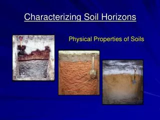
Soil Profile • Horizons- visibly distinct layers in the soil • A Horizon: Top and surface soil • B Horizon: Subsoil • C Horizon: parent material
C Horizon • Except for peat and muck soils consists of weathered rock and minerals • Looks like the rock it came from • May be soft enough to dig in or to crumble. • Very few plant roots
B Horizon • More thoroughly weathered • Often a different color • Contains little organic matter • May be much finer and harder packed • Plant roots begin to appear
A Horizon • Surface • High organic matter content • May be grayish, brownish or blackish in color as a result of humus content • Most productive • Most plant nutrients are available here
Slope • Single most important factor in determining the productive potential of the soil • Affects productive potential in many ways • Runoff rates • Relates to the danger of soil erosion • Affects the use of farm machinery • Size and shapes of fields
Texture • The proportions of sand, silt and clay • Course soils have more sand • Fine soils have more clay.
Soil Drainage • How well water flows through the soil naturally • Well drained soils-excess water moves out quickly • Poorly drained soils- hold excess water
Flood Hazard • How likely a field will receive flood damage • Frequent flood plains do not have good productive potential • Example: James River Bottom
Erosion • Refers to the degree that the soil has already been damaged. • May range from none to severe
Top Soil & Subsoil Thickness • Refers to the depth of each layer that is available for plant root growth. • Very thin top and subsoil’s limit crop production
Land Capability Classes • Categorize the productive potential of the soil • System begins with class 1 (most useful) to class 8 (least useful)
Class 1 • Very good, productive land • Nearly level • Well drained • Medium textured • Not subject to erosion or flooding • Easily cultivated • Very little land is class 1; even in the most productive farming areas!
Class 2 • Good for all types of farming • Has some limitations • Gentle slope • Suffers from the effects of past erosion • Less than ideal soil depth • May also have drainage problems that can be corrected with the use of drainage systems • Requires careful soil management to prevent erosion damage
Class 3 • Moderately good land • May be cultivated and farmed regularly but it has some important limitations • Moderate slope; making it high susceptible to erosion damage • May already have severe erosion damage • Drainage problems • Shallow rooting zone • Some shallow wetlands are Class 3 if they can be improved with drainage systems • Should be farmed with care to prevent erosion damage
Class 4 • Severe limitations • Can be cultivated with careful soil management practices • May have strong slope and be subject to severe erosion • May be very shallow • May be very dry or very wet • If wet even drainage systems may still allow occasional water logging
Class 5 • Nearly level • Little erosion hazard but may be in a frequent floodplain • May be very wet, very dry or very rocky • Swampy areas are generally class 5 • Quite suitable for pasture, wildlife habitat or forest production
Class 6 • Serious limitations • May have very rocky or very shallow unusable surface soil. • Can be used for tree production, permanent pasture or wildlife habitat
Class 7 • Severely limiting properties • May be very steep • May be severely eroded with deep gullies • Very strong slope with course soils may cause land to be rated at a class 7 • May be impractical for establishing pasture but native grasses may be utilized with controlled grazing • Land may be used for forest production, wildlife and recreation
Class 8 • Has one or more extreme limitations • Examples of Class 8 land • Sand dunes • River washes • Stream beds • Lake bottoms • Other nearly barren areas
Soil Classification • NRCS and USDA use a soil taxonomy • They are broken down into: • Order • Suborder • Great Group • Subgroup • Family • Series
Deep, well drained, loamy soil, Represents many soils formed in South Dakota under the influence of prairie grass The dark color of the surface layer is a result of decayed plants and other materials that have been deposited over thousands of years. Of major economic importance to SD because it is used as crop or rangeland. Houdek
South Dakotas State Soil • Designated as the StateSoil in 1990 • Has been mapped on about 600,000 acres. • Total Land Area of SD is 75,885 sq mi. or 48,566,400 acres • Average annual precipitation is 22 inches, • Average annual air temperature is about 48 F.
Houdek Soil Profile Houdek Soil Profile Surface layer: dark grayish brown loam Subsoil - upper: dark grayish brown clay loam Subsoil - middle: grayish brown clay loam Subsoil - lower: light olive brown clay loam Substratum: light yellowish brown clay loam