Download

1 / 32
320 likes | 326 Views
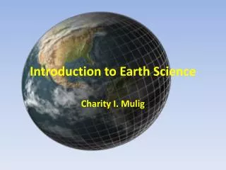
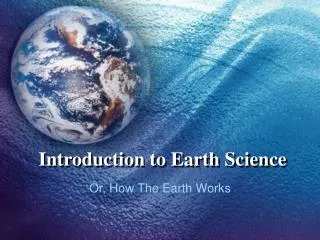
Introduction to Earth Science. Overview: Copy the slides with a yellow background!. Essential Questions. What does an Earth Scientist study? What information do various maps give to an Earth Scientist? How do Earth Scientists (and all scientists) seek knowledge?. Overview of Earth Science.

E N D
Introduction to Earth Science Overview: Copy the slides with a yellow background!
Essential Questions • What does an Earth Scientist study? • What information do various maps give to an Earth Scientist? • How do Earth Scientists (and all scientists) seek knowledge?
Overview of Earth Science • Earth science is the name of the group of sciences that deals with Earth and its neighbors in space. • Earth science is divided into four broad categories:
The Earth Sciences • Geology—the study of the solid Earth • Oceanography—the study of the Earth’s oceans • Meteorology—the study of the Earth’s atmosphere • Astronomy—the study of the Earth’s place in the universe
Differentiation • As the newly formed Earth cooled layers formed through a process called differentiation. • Denser elements (iron and nickel) sink to the Earth’s core. • Lighter rocks and materials migrate outward forming the mantle and crust.
A View of the Earth • Earth consists of 4 major spheres: • Hydrosphere • Atmosphere • Geosphere • Biosphere
Earth’s Major Spheres • The hydrosphere includes all liquid water on Earth—both saltwater and fresh water. • The atmosphere consists of the gaseous envelope surrounding the Earth. • Although the atmosphere extends more than 100km up, 90% is within 16km of the surface.
Earth’s Major Spheres • The biosphere includes all life on Earth. • The biosphere is concentrated in a zone that extends from the ocean floor upward several kilometers in the atmosphere. • The geosphere consists of the solid parts of the planet and is not uniform. • Based on differences in composition it is divided into three main regions, the core, the mantle, and the crust.
Geosphere Divisions • The dense core has two parts; a solid inner core and a liquid outer core. • The rocky mantle is divided into an lower mantle and upper mantle. • The rock in the upper part of the upper mantle is somewhat flexible and pliable—it’s called the asthenosphere (weak sphere).
Geosphere Divisions • The outer crust is divided into continental crust and oceanic crust. • This rigid outermost layer is called the lithosphere (rock sphere).
Plate Tectonics • The lithosphere is broken into several sections called plates. • The Theory of Plate Tectonics states that earthquakes, volcanoes, mountain building, and the movement of continents are the result of the movement of lithospheric plates.
Representing Earth’s Surface • Specifying a location on Earth’s surface is done using a grid system of latitude and longitude. • Latitude is the distance north or south of the equator (measured in degrees). • Longitude is the distance east or west of the prime meridian (also in degrees).
Maps and Mapping • No matter what type of map is made, some portion of the surface will always appear too small, big, or out of place. • Cartographers (mapmakers) have found ways to limit the distortion of shape, size, distance, and direction.
The Mercator Projection • Made by taking slices of a globe’s surface and stretching the ends to meet. • Directions accurate • Size and distance distorted.
Robinson Projection • Shows most distances, sizes, and shapes accurately. • Distortions present along edges.
Other map projections: • A conic projection is made by wrapping a cone around the Earth at a particular line of latitude. (almost no distortion at that line) • A gnomonic projection is made by placing a sheet of paper on a globe so that it is touching only one spot. • See page 13 in text.
Topographic Maps • Topographic maps show Earth’s elevation using contour lines. • All spots along a particular contour line have the same elevation.
Topographic Maps • The contour interval on a topo map gives the user the difference in elevation between each contour line. • Geologic Maps are those that also contain information about the type and age of rock formations in the area.
More on maps • All maps represent a certain area so a scale is included to compare actual distances. • Satellites have made accurate cartography much simpler than in the past.
Earth System Science • Earth system science aims to study the Earth as a system made up of numerous interacting parts, or subsystems. • A system can be any size group of interacting parts that form a complex whole.
Earth as a System • The Earth system is powered by 2 sources of energy: • The Sun– which drives external processes in the atmosphere, hydrosphere, and at the surface. • The Earth’s interior heat—which drives plate tectonics.
Each system affects the other. • The actions of nature and people produce changes in all of the other parts of the Earth system. • Resources (some renewable, some not), population, pollution, global warming, species extinction, etc. are some examples.
Scientific Inquiry • All science is based on two big assumptions: • The universe behaves in a consistent and predictable manner. • Through study, we can understand this behavior.
Scientific Method (Phrase) • Purple Purpose-Reason for experiment • Hippos Hypothesis- Educated guess of outcome • Play Procedure-Steps/Experiment • Dominoes Data-Info collected/recorded • And Analysis-Analyze data for results • Checkers Conclusion-Is hypothesis correct or not and possibly why
Hypothesis • Once observations have been made and data gathered, scientists try to explain how or why things happen in the manner observed. • They state a possible explanation called a scientific hypothesis.
Theory vs. Law • Once further observations have been made and/or tests performed, scientists either accept, modify, or reject their hypothesis. • A Theory is based on many observations. A Law is accepted as the best explanation of observable facts and proven by experiments.