Download
1 / 56
560 likes | 575 Views
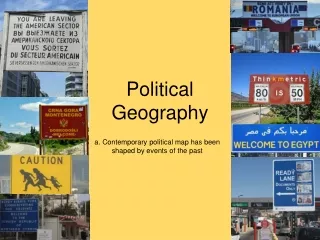
Political Geography. Chapter 8. How is Space Politically Organized into States and Nations?. Political Geography. Political Geography – the study of the political organization of the world. Accra, Ghana---Statue of Kwame Nkrumah, the first president of Ghana. State.

E N D
Political Geography Chapter 8
Political Geography Political Geography – the study of the political organization of the world. Accra, Ghana---Statue of Kwame Nkrumah, the first president of Ghana
State State – a politically organized territory, administered by a sovereign government, with a permanent population, and a defined territory. To be a state, an entity must be recognized as such by other states. (refers to a country, not a political subdivision like in the United States.) There are currently 213 states in the world that have claimed sovereignty
Territoriality – attempt by an individual or group to affect, influence, or control people, phenomena, and relationships, by delimiting and asserting control over a geographic area --Robert Stack, geographer • Sovereignty – having a recognized right to control a territory, both politically and militarily • Territorial Integrity – Under international law, a government has the right to keep the borders and territory of a state intact and free from attack.
The Modern State Idea • The Peace of Westphalia • What defined the European continent as territorially defined states • 1648- came out of years of fighting over religion (Thirty Years’ War) • The idea of a state that is tied to a particular territory with defined boundaries came out of Europe and diffused through: • colonialism
The countries we perceive as “natural” and “always existing” are relatively recent phenomena. In 1648, Europe was divided into dozens of small territories.
Nations • Nation – a culturally defined group of people with a shared past and a common future who relate to a territory and have political goals. • People construct nations to make sense of themselves. • Nations are “imagined communities” -Benedict Anderson • imagined = you will never meet all the people in your nation • community = you see yourself as part of it
Nation-States A politically organized area in which nation and state occupy the same space. - Ethnically homogeneous • Where at least 95% of the population in the state is of one ethnicity. • Examples: • Albania, Armenia, Bangladesh, Egypt, Estonia, Hungary, Iceland, *Japan*, Lebanon, Lesotho, Maldives, Malta, Mongolia, North and South Korea, Poland (after WWII), Portugal, Swaziland
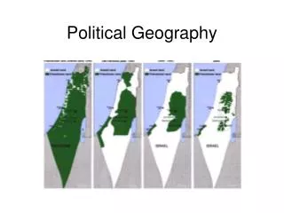
Multinational State – A state with more than one nation. - In essence, a state where there is more than one kind of ethnicity comprising the population. The Former Yugoslavia
Stateless Nation –a nation without a state… a group of people without a defined state to live in
European Colonialism and the Diffusion of the Nation-State Model • Colonialism (Colonization) - a physical action in which one state (colonizer) takes over control of another, taking over the government and ruling the territory as its own. Two Waves of European Colonialism: 1500 - 1825 1825 - 1975
Colonialism • Rule by an autonomous power over a subordinate people and place. • Often established and maintained through political structures, also creates unequal cultural and economic relations. • Because of the magnitude and impact of European colonialism, the term generally refers to that particular endeavor.
Dominant Colonial Influences, 1550-1950 This map shows the dominant influence, as some places were colonized by more than one power in this time period.
Colonization • Due to colonization, many states have adopted forms of mercantilism: • Generally, associated with the promotion of commercialism and trade. • Specifically, the policy of European states during the 16th to 18th centuries to promote a state’s economic purpose in the contest of acquisation of resources (gold, silver, etc) and the maintenance of a favorable trade balance (more exports than imports)
Two Waves of Decolonization First wave – focused on decolonization of the Americas Second wave – focused on decolonization of Africa and Asia
The World Economy Immanuel Wallerstein’s World-Systems Theory: • The world economy has one market and a global division of labor. • Although the world has multiple states, almost everything takes place within the context of the world economy. • The world economy has a three-tier structure.
Three Tier Structure Core Processes that incorporate higher levels of education, higher salaries, and more technology * Generate more wealth in the world economy Periphery Processes that incorporate lower levels of education, lower salaries, and less technology * Generate less wealth in the world economy Semi-periphery Places where core and periphery processes are both occurring. Places that are exploited by the core but then exploit the periphery. * Serves as a buffer between core and periphery
Construction of the World Economy Capitalism – people, corporations, and states produce goods and services and exchange them in the world market, with the goal of achieving profit. Commodification – the process of placing a price on a good and then buying, selling, and trading the good. Colonialism – brought the world into the world economy, setting up an interdependent global economy.
1950’s----Richard Hartshorne (political geographer) described the forces that countries must deal with: • Centrifugal forces- forces that tend to divide a country. • Centripetal forces- forces that tend to unite or bind a country together • Instead of creating a balance of the two, governments attempt to unify the state through nation-building.
Two Common Forms of Government • Unitary – highly centralized government where the capital city serves as a focus of power. • Ex: Mexico, China, Japan, U.K. • Federal – a government where the state is organized into territories, which have control over government policies and funds. • Ex: United States, Nigeria • With a federal government comes Democracy- where the people have the ultimate say over what happens in the state.
Nigeria’s Federal Government – Allows states within the state to determine whether to have Shari’a Laws Shari’a Laws Legal systems based on traditional Islamic laws
The U.S. Federal Government – Allows states within the state to determine “moral” laws such as death penalty, access to alcohol, and concealed weapons. Minnesota’s concealed weapons law requires the posting of signs such as this on buildings that do not allow concealed weapons.
Devolution Movement of power from the central government to regional governments within the state. Many things can cause devolutionary movements: • Ethnocultural reasons: ethnic and/or cultural differences require the state to split into territories • Economic reasons: the state may want to switch their currency and/or let their territories have more power over funds • Spatial reasons: due to too much space and/or being fragmented, a move to being a federal state may be easier
Ethnocultural Devolutionary Movements Eastern Europe devolutionary forces since the fall of communism Ethnic and/or cultural reasoning behind the movement of power
Economic Devolutionary Movements Scotland rise in independence movement is coupled with: - European Union - Scotland’s oil resources
Economic Devolutionary Movements Catalonia, Spain Barcelona is the center of banking and commerce in Spain and the region is much wealthier than the rest of Spain.
Spatial Devolutionary Movements Hawai’i Because of being so far from the U.S., it is easier for Hawaii to make their own decisions with what the U.S. government gives them instead of D.C. trying to control what goes on there.
Electoral Geography • A state’s electoral system is part of its spatial organization of government. In the United States: - territorial representation - reapportionment - voting rights for minority populations
Gerrymandering – drawing voting districts to benefit one group over another. Majority-Minority districts drawn so that the majority of the population in the district is from the minority. Gerrymandering explained
How are Boundaries Established, and Why do Boundary Disputes Occur?
Boundary – a vertical plane that cuts through the rocks below and the airspace above, dividing one state territory from another.
Boundaries often divide resources, such as oil between Kuwait and Iraq
Establishing Boundaries • Define—treaty, legal document • Delimit—draw on a map • Demarcate—mark the boundary • Administrate---determine how the boundary will be maintained and how goods and people will cross the boundary
Types of Boundaries • Geometric boundaries – based on grid systems • eg. Boundary between the US and Canada--------------Oregon Treaty 1846----49th parallel • Four Corners • Physical-political boundaries – follow an agreed-upon feature in the physical geographic landscape. • eg. Boundary between the US and Mexico • Rio Grande River
Utah, Colorado, Arizona, New Mexico
Types of boundaries • Antecedent boundary- established before an area is well populated/before cultural landscape develops • Subsequent boundary—drawn after the cultural landscape is in place • Consequent boundary—drawn to accommodate existing language, religious, or other cultural boundaries
Superimposed boundary- forced---ignore cultural and tribal differences across space. Example: much of Africa due to Colonization • Relic (relict) boundary- a former boundary line that is still visible and marked by some cultural landscape. Examples: Great Wall of China, the Berlin Wall
Boundary Disputes • Definitional—focus on the legal language of the boundary agreement • Locational—center on the delimitation and possibly the demarcation of the boundary • Operational—involve neighbors who differ over the way their border should function • Allocational---disputes over resources
Irredentism--- any position advocating annexation of territories administered by another state on the grounds of common ethnicity or prior historical possession, actual or alleged. Some of these movements are also called pan-nationalist. • Somalia has many border conflicts with Ethiopia over the rights of Somalis living in Ethiopia
The Ocean Frontier • Law of the sea- law establishing state’s rights and responsibilities concerning the ownership and use of the Earth’s seas and oceans and their resources. • -Foreign ships can’t pass within 12 nautical miles of the country’s shore. • Exclusive Economic Zone (EEZ) • Exclusive economic rights extend 200 nautical miles from shore • Natural resources, fishing, etc. • Usually beyond continental shelf • Often overlap, generally split halfway, but many areas are under dispute