Download

1 / 24
240 likes | 430 Views
A GIS FOR DAUPHIN ISLAND. TROY UNIVERSITY. USGS QUADRANGLE “ Biloxi, Miss.”- c. 1982. Pre-Katrina- April 17, 2005; NASA imagery. Post-Katrina- April 17, 2005; NASA imagery. A GIS for Dauphin Island.

E N D
A GIS FOR DAUPHIN ISLAND TROY UNIVERSITY TROY SURVEYING & GEOMATICS SCIENCES
USGS QUADRANGLE “ Biloxi, Miss.”- c. 1982 TROY SURVEYING & GEOMATICS SCIENCES
Pre-Katrina- April 17, 2005; NASA imagery TROY SURVEYING & GEOMATICS SCIENCES
Post-Katrina- April 17, 2005; NASA imagery TROY SURVEYING & GEOMATICS SCIENCES
A GIS for Dauphin Island • This outreach program will help to develop a GIS tool for future planning- similar in result to planting sea oats in the sand to increase the chance of survival of the dune TROY SURVEYING & GEOMATICS SCIENCES
Project Objectives • Develop a Geographical Information System for the Town of Dauphin island • Identify and create a database of the existing infrastructure of Dauphin Island- the Town and its environmental matrix • Integrate the infrastructure database with a layered digital map base for analytical and management purposes TROY SURVEYING & GEOMATICS SCIENCES
The Town of Dauphin Island • Located at the the Mouth of Mobile Bay in Mobile County, Alabama • Is classified as a barrier island situated on the Northern Gulf of Mexico TROY SURVEYING & GEOMATICS SCIENCES
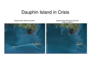
A Brief Historical Perspective • Was explored in 1699 by Sieur Pierre le Moyne d’Iberville who founded Colonie Louisiane • Pelican Bay on the south shore of the island the French colonists roadstead until 1718 when a hurricane closed Pelican Pass trapping 3 ships in the harbor • The island has suffered many devastating hurricanes that have drastically altered its shoreline- especially the transitory west end. TROY SURVEYING & GEOMATICS SCIENCES
After Guillame de ’Lisle- a portion “Carte de la Louisiane et du cours de Mississippi”, Amsterdam, 1718; Rucker Agee Map Collection TROY SURVEYING & GEOMATICS SCIENCES
After Guillame de L’Isle- Nuremberg, 1730; W.S. Hoole Special Collections Library TROY SURVEYING & GEOMATICS SCIENCES
After John Mitchell- a portion of “Amerique Septentrionale”, Paris, 1756; Alabama Department of Archives & History TROY SURVEYING & GEOMATICS SCIENCES
After John Russell- a portion of “State of America”, London, 1801; Rucker Agee Map Collection TROY SURVEYING & GEOMATICS SCIENCES
After Antoine Francois- a portion of “Carte de Etats”, Paris 1812; Rucker Agee Map Collection TROY SURVEYING & GEOMATICS SCIENCES
After Aaron Arrowsmith- a portion of “A Map of the United States”, London, 1817; Rucker Agee Map Collection TROY SURVEYING & GEOMATICS SCIENCES
After Henry Schenk, Philadelphia, 1823; Alabama Department of Archives and History TROY SURVEYING & GEOMATICS SCIENCES
After John La Torrette- a portion of “An Accurate Map of the State of Alabama & West Florida”, New York, 1837; Rucker Agee Map Collection TROY SURVEYING & GEOMATICS SCIENCES
After James A. Weakley, Surveyor General of Alabama, Florence, Alabama, 1841; W.S. Hoole Special Collection TROY SURVEYING & GEOMATICS SCIENCES
After John Barthomew, Edinburgh, 1856; Alabama Department of Archives and History TROY SURVEYING & GEOMATICS SCIENCES
After U.S. Coast Survey, Washington, 1852; Rucker Agee Map Collection TROY SURVEYING & GEOMATICS SCIENCES
After the U.S. Coast & Geodetic Survey, Washington, 1933; Rucker Agee Map Collection TROY SURVEYING & GEOMATICS SCIENCES
Expected results • Create an important planning tool for the Town of Dauphin Island, not only for day to day management, but also for long range municipal planning. • This system will also help the Town of Dauphin Island to recover and to mitigate the adverse effects of catastrophic events (e.g, Hurricane Katrina). TROY SURVEYING & GEOMATICS SCIENCES
Near Term Schedule • Meetings with the Town of Dauphin Island are scheduled in November 2007 to discuss expectations and examine existing mapping & infrastructure databases. • Formulate a schedule for implementing upgrades to the Town’s existing data infrastructure to create a workable GIS. • Seek assistance & funding from State & Federal agencies to help in the cost & implementation of the GIS • Work with other agencies to accomplish the goals set forth. TROY SURVEYING & GEOMATICS SCIENCES
Pre-Katrina- April 17, 2005; NASA imagery TROY SURVEYING & GEOMATICS SCIENCES
Post-Katrina- April 17, 2005; NASA imagery TROY SURVEYING & GEOMATICS SCIENCES