Download
1 / 11
120 likes | 295 Views
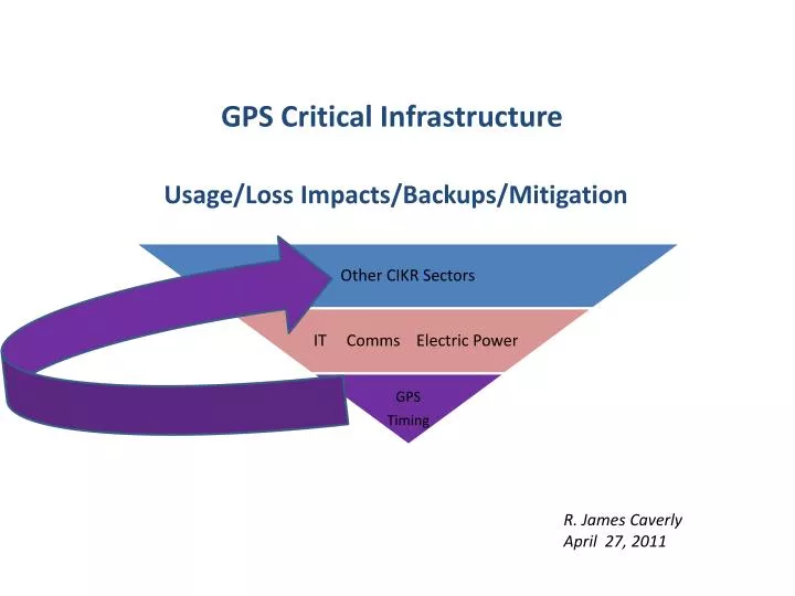
GPS Critical Infrastructure Usage/Loss Impacts/Backups/Mitigation. R. James Caverly April 27, 2011. Stock Exchanges. ATM Networks. Substations. Internet Banking. Energy Plants. Power Grids. Banks/ Nodes. GPS Time. GPS Time. GPS Supporting Power Grid Systems.

E N D
GPS Critical InfrastructureUsage/Loss Impacts/Backups/Mitigation R. James Caverly April 27, 2011
Stock Exchanges ATM Networks Substations Internet Banking Energy Plants Power Grids Banks/ Nodes GPS Time GPS Time • GPS Supporting Power Grid Systems • GPS Supporting Banking Operations GPS GPS Time & Position GPS Time & Position Switching Towers & Signals Rail Yards Wireless Internet C2 Centers Comms Networks Access GIS / Map Relay Position To 911 Dispatch Air Traffic Control Ship Routing • GPS Supporting Transportation Systems • GPS Supporting Communications Systems Critical Infrastructure GPS Dependencies GPS Critical Infrastructure Timing Study: Usage/Loss Impacts/Backups/Mitigation
Summary of CI GPS Timing Usage • Of the 18 CIKR sectors, 15 use GPS timing • Major uses of GPS timing are for: • Network and phase synchronization in wireline and wireless networks (Communications/IT Sectors) used in multiple critical infrastructures • Precise frequency generation and stabilization for single frequency wireless networks (LMR simulcast) • Phase synchronization in Electric Power, Nuclear Power, and Dams/Hydroelectric power sectors/subsectors • Process scheduling, control, and synchronization in Oil and Natural Gas/Chemical/Critical Manufacturing/DIB sectors • Precise time stamping of data, transactions/high-frequency trading in Banking & Finance/Postal and Shipping sectors • In general, GPS timing used in distributed interconnected systems that require synchronization for monitoring, control, production, transaction tracking, and other functions • Of the 15 GPS timing using CIKR sectors, GPS timing is deemed Essential in 11 of them • Essential in more than half of the Nation's CIKR Sectors • Dependence is growing over time GPS Critical Infrastructure Timing Study: Usage/Loss Impacts/Backups/Mitigation
GPS Time and Frequency System (TFS) Holdover Oscillator It is the TFS, not the GPS Receiver alone, that should be considered as the building block for timing, frequency, and time-of-day services. GPS Critical Infrastructure Timing Study: Usage/Loss Impacts/Backups/Mitigation
CIKR Sector Oscillators And Holdover Times GPS Critical Infrastructure Timing Study: Usage/Loss Impacts/Backups/Mitigation
CIKR Impacts Under GPS Outage Scenarios GPS Critical Infrastructure Timing Study: Usage/Loss Impacts/Backups/Mitigation
GPS Timing Impact Assessment Approach Result: Limited to Moderate Regional Impacts Result: Severe Regional/National Impacts Result: Moderate to Severe National Impacts GPS Critical Infrastructure Timing Study: Usage/Loss Impacts/Backups/Mitigation
Impact on GPS and CI Feb 20 – 24> R4 Solar Event Scenario • An R4 event is caused by a disturbances of the ionosphere caused by X-ray emissions from the Sun. • A “Severe” (R4) High Frequency (HF) radio frequency event; HF radio communications blackout on most of the sunlit side of Earth for one to two hours. HF radio contact lost during this time. • GPS Impacts: Loss of signal due to: • Ionospheric plasma density irregularities • Refraction and diffraction of GPS signal propagating through the irregularity • Rapid amplitude and phase variations • Locations: • Night-time equatorial regions (severe, common) • Polar regions (usually mild, rare) • All latitudes during geomagnetic storms (severe, rare) • Time Duration of Event: 10s of minutes to multiple hours over multiple days • Radar degradation due to similar causes as HF radio and GPS signal impacts described above
Impacts on GPS and CI from 25-26 FEB G5 Geomagnetic Storm Scenario • Electric Power outages due to: • Geomagnetic Storm induces ground currents and Earth surface potentials • Geomagnetically Induced Currents (GIC) at substations (damages equipment) and on power lines (causes faults\lines to trip out of service) • Loss of control caused by corrupted grid state estimation\situational awareness due to loss of GPS timing synchronization of data from SCADA and Synchrophasors • Communications degradations consist of: • HF Blackouts • Satellite communications losses • CDMA Cellular and Land Mobile Radio Simulcast loss due to loss of GPS timing synchronization • GPS Impacts
Geomagnetic Storm Caused Regional Power Outages Source:Kappenman, J. 2010. “Electric Power Grid Vulnerability to Geomagnetic Storms.”