Download
1 / 1
10 likes | 136 Views
Large scale forcing of the North Atlantic storm track and its moisture transports David Brayshaw , Brian Hoskins and Mike Blackburn. Contact d.j.brayshaw@rdg.ac.uk The University of Reading, UK. Removing the Rocky mountains. Motivation

E N D
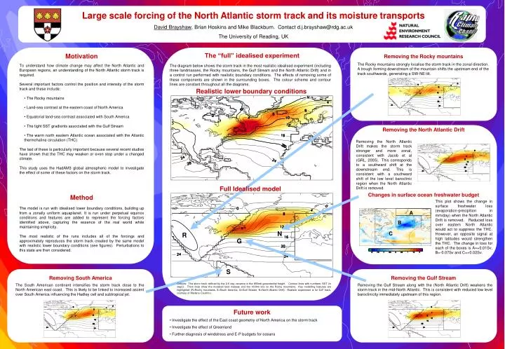
Large scale forcing of the North Atlantic storm track and its moisture transports David Brayshaw, Brian Hoskins and Mike Blackburn. Contact d.j.brayshaw@rdg.ac.uk The University of Reading, UK Removing the Rocky mountains • Motivation • To understand how climate change may affect the North Atlantic and European regions, an understanding of the North Atlantic storm track is required. • Several important factors control the position and intensity of the storm track and these include: • The Rocky mountains • Land-sea contrast at the eastern coast of North America • Equatorial land-sea contrast associated with South America • The tight SST gradients associated with the Gulf Stream • The warm north eastern Atlantic ocean associated with the Atlantic thermohaline circulation (THC) • The last of these is particularly important because several recent studies have shown that the THC may weaken or even stop under a changed climate. • This study uses the HadAM3 global atmospheric model to investigate the effect of some of these factors on the storm track. • Method • The model is run with idealised lower boundary conditions, building up from a zonally uniform aquaplanet. It is run under perpetual equinox conditions and features are added to represent the forcing factors identified above, capturing the essence of the real world while maintaining simplicity. • The most realistic of the runs includes all of the forcings and approximately reproduces the storm track created by the same model with realistic lower boundary conditions (see figures). Perturbations to this state are then considered. The Rocky mountains strongly localise the storm track in the zonal direction. A trough forming downstream of the mountain shifts the upstream end of the track southwards, generating a SW-NE tilt. A B C Future work • Investigate the effect of the East coast geometry of North America on the storm track • Investigate the effect of Greenland • Further diagnosis of windstress and E-P budgets for oceans The “full” idealised experiment The diagram below shows the storm track in the most realistic idealised experiment (including three landmasses, the Rocky mountains, the Gulf Stream and the North Atlantic Drift) and in a control run performed with realistic boundary conditions. The effects of removing some of these components are shown in the surrounding boxes. The colour scheme and contour lines are constant throughout all the diagrams. Realistic lower boundary conditions Removing the North Atlantic Drift Changes in surface ocean freshwater budget Removing the North Atlantic Drift makes the storm track stronger and more zonal, consistent with Jacob et al (GRL, 2005). This corresponds to a southward shift at the downstream end. This is consistent with a southward shift of the low level baroclinic region when the North Atlantic Drift is removed. Full Idealised model This plot shows the change in surface freshwater loss (evaporation-precipition in mm/day) when the North Atlantic Drift is removed. Reduced loss over eastern North Atlantic would act to suppress the THC. However, an opposite signal at high latitudes would strengthen the THC. The change in loss for each of the boxes is A=+0.01Sv, B=-0.07Sv and C=+0.02Sv. N R G S Removing South America Removing the Gulf Stream Colours: The storm track defined by the 2-6 day variance in the 850mb geopotential height. Contour lines with numbers: SST (in degC). Thick lines show the modeled land masses and the 1000m line on the Rocky mountains. Key modelling features are highlighted (R=Rocky mountains, S=South America, G=Gulf Stream, N=North Atlantic Drift). Realistic experiment is for DJF track, courtesy of Mariane Coutinho. The South American continent intensifies the storm track close to the North American east coast. This is likely to be linked to increased ascent over South America influencing the Hadley cell and subtropical jet. Removing the Gulf Stream along with the (North Atlantic Drift) weakens the storm track in the mid-North Atlantic. This is consistent with reduced low level baroclinicity immediately upstream of this region.