Download
1 / 61
660 likes | 769 Views
DSIG-5000TU Tactical Satellite Image Groundstation. Produced by Northern Video Graphics & Quorum Communications. Presentation Contents. Company Info DSIG-5000TU Current Users Fielded Capabilities Hardware Software Future Possibilities.

E N D
DSIG-5000TUTactical Satellite Image Groundstation Produced by Northern Video Graphics & Quorum Communications
Presentation Contents • Company Info • DSIG-5000TU Current Users Fielded Capabilities Hardware Software • Future Possibilities Edited and Presented by Russ Green, co-founder Northern Video Graphics
Northern Video Graphics, Inc. Equipment and Software for Meteorologists Since 1981 www.nvgweather.com
Northern Video Graphics • Founded in 1981, by: • Three Physicists from the University of Minnesota • Original product: • Video Facsimile Display Unit (for weather fax) • Products evolved over the years: • From: Stand-Alone Acquisition and Display Units • To: Adapter Boards and Software for PCs • To: Software for Third Party Hardware (Quorum) • Customers: • Meteorologists: Educational, Private, Gov’t, Military • Other Vendors: Quorum, IPS, Marta, Sonalysts, etc.
Quorum Communications www.qcom.com
Quorum Communications Quorum was founded in 1988 by a small group who saw a need to provide cost effective high quality solutions in the satellite remote sensing field. Since that time, Quorum has grown to provide research centers, universities, and governments worldwide with the necessary equipment to receive and process satellite data.
DSIG-5000TU • Joint Development by Quorum and NVG • Spurred mostly by inquiries from military users as an • upgrade to older deployable weather fax systems • Currently over 50 systems fielded • Air Force Special Operations Command (AFSOC) • based at Hurlburt Field, FL • Joint Special Operations Command (JSOC) • based at Fort Bragg, NC • Deployed around the world
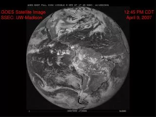
DSIG-5000TU Capabilities Worldwide data reception from Geostationary Satellites High rate and Low rate data streams supported Currently Eight Satellites on line GOES West, East, Atlantic GVAR and LRIT data Operated by USA-NOAA, over North and South America METEOSAT Second Generation (MSG) LRIT data Operated by Eumetsat, over Europe, Africa METEOSATPDUS/HRI data Operated by Eumetsat, over Mideast, India, Indian Ocean FY-2C,DSVISSR data Operated by China Met Agency, over China, SE Asia MTSATHRIT and LRIT data Operated by Japan Met Agency, over Japan, China, Australia
GOES WEST (135º W) GOES WEST GOES EAST GOES Atlantic MSG METEOSAT 7 FY-2D FY-2C MTSAT
GOES EAST (75º W) GOES WEST GOES EAST GOES Atlantic MSG METEOSAT 7 FY-2D FY-2C MTSAT
GOES Atlantic (60º W) GOES WEST GOES EAST GOES Atlantic MSG METEOSAT 7 FY-2D FY-2C MTSAT
MSG ( 0º ) GOES WEST GOES EAST GOES Atlantic MSG METEOSAT 7 FY-2D FY-2C MTSAT
Meteosat 7 (57º E) GOES WEST GOES EAST GOES Atlantic MSG METEOSAT 7 FY-2D FY-2C MTSAT
FY-2D (86º E) GOES WEST GOES EAST GOES Atlantic MSG METEOSAT 7 FY-2D FY-2C MTSAT
FY-2C (105º E) GOES WEST GOES EAST GOES Atlantic MSG METEOSAT 7 FY-2D FY-2C MTSAT
MTSAT (140º E) GOES WEST GOES EAST GOES Atlantic MSG METEOSAT 7 FY-2D FY-2C MTSAT
GOES LRIT - EMWIN GOES WEST GOES EAST GOES Atlantic MSG METEOSAT 7 FY-2D FY-2C MTSAT
The Hardware Fits in 2 Hard Cases, < 300 pounds total • Tactical 2.3 meter Dish Antenna • Tactical USB Receiver • Rugged Laptop Computer • Decryption Keys (for Eumetsat Satellites)
Tactical Dish Antenna • Features: • 2.3 meter (7.5 ft.) mesh dish • 10.5 dB typical G/T at 1691MHz • Integrated cavity dipole feed/downconverter • Integrated signal strength meter • Leveling adapter (for up to 20º tilt) • Single tool (allen driver) required for setup • Elevation over azimuth configuration • 6 petal reflector of heavy tubing and heavy mesh • Mount components hard black anodized • Antenna petals powder coated • Total antenna and tripod weight 45Kg (100 lbs) • Easy Setup, 15 minutes, 2 men Hardware Antenna Receiver Computer Decryption More Info: Link to PDF file
Tactical USB Receiver • Features: • QPSK, BPSK, PSK demodulation • Built in Viterbi decoding • Selectable RF inputs and IF bandwidths • -90 dBm to -50 dBm input range • USB 2.0 Interface for control and data transfer • Vacuum fluorescent display • Supports all current geo weather satellites • Optional support for polar satellites • Small size: 7¼ x 3½ x 12 inches • As fielded, configured for: • GOES GVAR & LRIT, MSG HRIT¹ & LRIT, • Meteosat PDUS, FY-2 SVISSR & LRIT¹, • MTSAT HRIT, LRIT & HiRID¹ • (¹ not currently available from satellites as specified) Hardware Antenna Receiver Computer Decryption More Info: Link to PDF file
Semi Rugged Portable Computer • As fielded: Panasonic Toughbook CF-51 • Magnesium alloy frame • 15 inch, 1600 x 1200 video screen • 1700 MHz CPU • 1 GB RAM • 60 GB Hard drive • Integrated wireless networking • Windows XP Professional • Available:Panasonic Toughbook CF-52 • faster CPU • more RAM • more disk space • up to 1920 x 1200 video screen Hardware Antenna Receiver Computer Decryption
Portable Computer Option • Panasonic Toughbook CF-30 • Designed using MIL-STD-810F • Full magnesium alloy case w/handle • Moisture-, dust-resistant LCD and keyboard • Sealed port and connector covers • Vibration-, shock- and drop-resistant • Daylight-readable 13.3” display • 1024x768, with touch screen option • Replaceable film touch screen protector • Shock-mounted, removable hard drive • Mobile broadband- and GPS-ready design • 8.4 lbs. Hardware Antenna Receiver Computer Decryption
Decryption Key Units • MKU (old style, for Meteosat PDUS) • 1” x 3” x 6.5”, 20 oz. • Fits and connects inside Tactical Receiver • Must be purchased / licensed from Eumetsat • SKU (new style, for MSG LRIT) • 1.7”x 4.9” x 8.2”, 28 oz. • Cable interface to Tactical Receiver, or • Cable interface to Serial Port via adapter • Power Cord to wall socket • Must be purchased / licensed from Eumetsat Hardware Antenna Receiver Computer Decryption
The Software Two Main Applications DSIG Ingest Software MEGAVIEW Display Software
DSIG Ingest Software • Runs on Windows platform • Works with USB receiver or Drive-Bay receiver • Captures imagery directly from data streams: • GOES GVAR and LRIT (including EMWIN) • MSG LRIT (including decryption) • METEOSAT PDUS/HRI (including decryption) • FY-2 SVISSR and LRIT (when compatible) • MTSAT HRIT and LRIT • Assembles imagery from: • XRIT (HRIT, LRIT) files from Eumetcast • Saves full image files, and/or • Cuts sectors on-the-fly via user definitions Software DSIG MEGAVIEW
DSIG Ingest Software • Startup Screen • Start automatically with last settings • Start with saved initialization file • for different satellite or data format • Start idled, to await manual setup Software DSIG MEGAVIEW
DSIG Ingest Software • Setup Tab Page • Set receiver type • Set parameters for receiver • USB receiver has no parameters • View start-up progress and status • Save current settings for future use Software DSIG MEGAVIEW
DSIG Ingest Software • Ingest Tab Page • Left Side shows receiving status • Right side allows setting of receiver : • Choice of two RF inputs, frequency and other parameters Software DSIG MEGAVIEW • Set all parameters at once with • dropdown list of Presets
DSIG Ingest Software • Files Tab Page • Choose method of file housekeeping • Choose format for file names • Choose time for file name • Choose overwrite or save dup files • Insert characters into file name • as indicator for post processing Software DSIG MEGAVIEW
DSIG Ingest Software • Raw Tab Page • Make settings to capture raw data • for future training • or trouble-shooting Software DSIG MEGAVIEW
DSIG Ingest Software • Sectors Tab Page • Set directory for saving all sectors • Specify the Sector Definition File • (default or user defined/edited) Software DSIG MEGAVIEW • Open window to show sector status
DSIG Ingest Software • Info Tab Page (GVAR, PDUS, SVSR) • View status and info for reception Software DSIG MEGAVIEW
DSIG Ingest Software • Info Tab Page (LRIT, HRIT) • View reception statistics Software DSIG MEGAVIEW • Open a Sector File Status window • Open a Product File Status window
DSIG Ingest Software • View Tab Page • View status of reception graphically Software DSIG MEGAVIEW
DSIG Ingest Software • History Tab Page • View history of reception • Choose verbose reporting • Copy history to clipboard for help • Open full log file for trouble-shooting Software DSIG MEGAVIEW
DSIG Ingest Software • XRIT Tab Page (has 9 sub-pages) • For HRIT or LRIT reception • Set parameters each type of file • Sector Files (example sub-page) • Enable/disable saving • Set directory • Set max. no. of files to keep • Set Sector Definition File to use Software DSIG MEGAVIEW
DSIG Ingest Software • XRIT Tab Page (has 9 sub-pages) • For HRIT or LRIT reception • Set parameters each type of file • EMWIN Files (example sub-page) • GOES LRIT only • Enable/disable saving • Set directories • Set max. no. of files to keep • Enable output for old EMWIN use Software DSIG MEGAVIEW
DSIG Ingest Software • Met Tab Page • For Meteosat specific functions • Set type of Key Unit • Verify Key Unit presence • Verify reception of decryption keys • View status of decryption • Set parameter overrides Software DSIG MEGAVIEW
DSIG Ingest Software Two page Quick-Start Guides for each satellite/format Can be laminated back to back for field use
DSIG Ingest Software Two page Quick-Start Scan/Sector Guides for each satellite/format Can be laminated back to back for field use
MEGAVIEW Display Software Easy-to-Use for the casual user Flexible and Powerful for the more serious user Software DSIG MEGAVIEW
MEGAVIEW Display Software • Features • Runs on Windows platform • Easy thumbnail- or icon-based image selection • Quick-button toolbar to control window visibility • Easy, flexible image color enhancement • Easy, flexible image window sizing and placement • Easy, flexible image zooming and panning • Easy, flexible image looping • Easy, flexible map, grid and lat-lon point overlays • Image windows can be linked – in time and location Software DSIG MEGAVIEW
MEGAVIEW Display Software Software DSIG MEGAVIEW The following slides are an attempt to simulate the start up and operation of Megaview
MEGAVIEW Display Software Hide Image Window by clicking on Quick Button Click Options for Menu Click Add Window to Select a Sector Image Control Image Windows with Floating or Docked Quick-Button Toolbar On the Sector Select Panel Click on a Sector Icon Say, GE_USI2 Megaview starts with an option to load Last Settings, or Other Settings from a saved Initialization File An Image Window appears
MEGAVIEW Display Software Show Image Window by clicking on dimmed Quick Button For each Sector Set Calibration File Set Color File Set Map File Set Map appearance Set Grid appearance Change the look of an image with the Sector Display Database (from Settings Menu)
MEGAVIEW Display Software Make complex Map Files with Labeled Points at particular latitude and longitude coordinates
MEGAVIEW Display Software Map Color changed Grid added Complex Map File used with Data Buoy points
MEGAVIEW Display Software Launch a new window Synchronized in time and location (from Files menu) Also, Use Display Database to Customize Icons for Quick Buttons and Sector Select window
MEGAVIEW Display Software Adjust colors interactively and save/load Color Files (from Color menu) Choose quadrants for each window successively say, Q1, Q2 Right click in image to bring up a dialog box for Size, Placement, etc.
MEGAVIEW Display Software Open more linked windows If desired, place them in other quadrants Linked windows can be zoomed and panned together