Download
1 / 34
340 likes | 466 Views
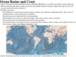
OCEAN BASINS. There is a copy of the oceanography text in the library at Des Plaines and Skokie. There is also a spiral bound note book at the Des Plaines library containing some of the overhead figures not seen in your text book. These figures also contain their web source.

E N D
There is a copy of the oceanography text in the library at Des Plaines and Skokie. There is also a spiral bound note book at the Des Plaines library containing some of the overhead figures not seen in your text book. These figures also contain their web source.
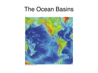
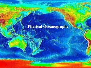
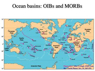
Two principal levels of Earth's surface (S&A 53) • 1. Land is 29.2% with average elevation 840 meters • 2. Ocean covers 70.8% with average depth 3800 m • A. earth-circling mountain ranges - mid-ocean ridges • B. deep-ocean trenches near the continents • C. continental margins separate distinctly different structures
Hypsographic curve (p 81) (Fig 3.4) (S&A 18) • Two different levels of Earth's crust • ocean bottom 11 km deep • land 9 km above sea level • become familiar with this diagram
Land and water unevenly distributed (S&A 15 & 16) • Northern Hemisphere • has more land, but still 60.7% ocean • the ocean is interrupted by continents • Southern Hemisphere • dominated by ocean 80.9% • connects all three major ocean basins • Pacific • Atlantic • Indian
Continents and Continental Margins (S&A 44) • Continental shelves--submerged edges of continents • Continental slopes--sides of continental blocks • Sea floor mapping Read Box 3.1 p 78 - 79
Continents and Continental Margins cont. • Submarine canyons - cut into edges of continents (Fig 3.10 a) (p 84) • Go to the net, and look up ‘submarine canyons pictures’. Look at the photographs of the animals etc. • Turbidity currents - sediment-laden current that flows off of a continental slope (Fig 3.10 e) (p 84) • Comparison of the Monterey submarine canyon and Arizona’s Grand Canyon (Fig 3.11) p 85 (S&A 47)
Mid-ocean ridges (S&A 51), (3.15) p 90 • Shallowest parts of the deep-ocean basins • Many small earthquakes on rift valleys • Active volcanoes from islands along the mid-ocean ridges
Mid-ocean ridges cont. • Mid-Atlantic Ridge • rugged, mountainous • conspicuous rift valley • occupies center of Atlantic basin • East Pacific Rise • broad, gently sloping • lies near eastern side of basin • intersects North America in the Gulf of CA
Mid-ocean ridges cont. • Mid-Indian Ridge • near western edge of Indian Ocean • Resembles Mid-Atlantic Ridge
Mid-ocean ridges cont. • All ridges connect in the ridge that circles Antarctica
Deep-ocean floor • About 30% of Earth's surface • Abyssal hills and plains (Fig 3.12) (p 87) ( S&A 49) • low hills (volcanic peaks) and ridges common on deep-ocean floor • abyssal plains common near continents are flat and sediment covered • Know the portions of the ocean basin floor. There are 9 new terms here. • 1. Continent 2. Shelf 3. Shelf break 4. Slope 5. Rise 6. Abyssal hill 7. Guyot 8. Island 9. Abyssal plain
Transform faults • (there are 1000s) • Intersect mid-ocean ridges at right angles (Fig 3.19) p 94 and Fig 3.15 p 90 (xyrox)
Transform faults • Rugged ridges • narrow (10 -100 km) elongated belts of rugged topography with steep ridges and valleys • Many earthquakes between offset segments of mid-ocean ridge and are called transform faults • Transform faults continue into the continents. Mendocino -> Cape Mendocino, CA to form -> San Andrea's Fault connect with E. Pacific Rise in Gulf of CA (S&A 37)
Definitions • Transform fault is a seismically activearea that offsets the axis of a mid-ocean ridge. • Fracture zone is a seismically inactivearea that shows evidence of pasttransform fault activity
Figure 3.15 p 90 • Mid ocean ridge with • Transform faults • Fracture zones
Trenches (Fig 3.13) (P 89)(S&A 52) • Relatively narrow, but many thousands of kilometers long • Most occur in the Pacific (western side) • Deepest part of ocean floor--Mariana Trench, SW of Japan (remember the Challenger) • Peru-Chile trench (Fig 3.14) (P 89) • Associated with active volcanoes and largest earthquakes
Volcanoes and Reefs • Common on ocean floor • Reef formation (Fig 2.27) (p 65) • 1. Fringing Reef • greatest conc. of living reef is in the seaward margin • 2. Barrier Reef • subsidence gives the reef more room to grow • 3. Atoll • form around subsiding continent shelves or around islands of sinking volcanic islands
Volcanoes and Reefs cont. • Go to Google and look up shield volcanoes • Large volcanoes on earth • Hawaiian Islands • shield volcanoes - stand several kilometers higher than the deep-ocean floor • Actually look like volcanoes
A shield volcano is typically built by eruptions of fluid, basaltic lava. The take on the appearance of shield with the convex side facing upward. The Hawaiian Islands are an example of shield volcanoes.
Oceanic plateaus • Elevated parts of ocean floor (3% of ocean floor) • Micro continents • Volcanic ridges • greatest concentration of living reef is on the seaward margin, why do you think this is correct?
Worlds four major oceans • Pacific Ocean • Atlantic Ocean • Indian Ocean • Arctic Ocean
Pacific Ocean • Deepest ocean basins and occupies > 1/3 of earth's surface • Mountain building dominates • Submerged continental margins are narrow because the mountain slopes continue below sea level - little effect from rivers • Many islands - most are volcanic and many are active
Atlantic Ocean • Relatively shallow • Conspicuous Mid-Atlantic Ridge • Few islands--Greenland (largest), Iceland, Falkland Islands • Large amts. of water from rivers - Congo and Amazon • Many marginal ocean basins (we will see these later) • Arctic Ocean is an arm of the Atlantic
Indian Ocean • Southern Hemisphere - smallest of the three previous oceans • Three rivers empty into it - Ganges and Brahmaputra (India), Indus (Pakistan) • Red Sea and Arabian Gulf - areas of intense evaporation (high salinity) • Few islands - Madagascar - Few volcanic islands
Arctic Ocean • circles the N pole
Marginal ocean basins • Many are isolated from main basin by volcanic island chains • Bering Sea • Some elongated basins formed within continental blocks • Gulf of California • Red Sea
Marginal ocean basins • Shallow seas occur oncontinents • Hudson Bay • North Sea • Mediterranean Sea