Download
1 / 35
350 likes | 754 Views
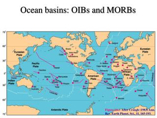
OCEAN BASINS. There is a copy of the oceanography text in the library at Des Plaines and Skokie. Maps due today. Two principal levels of Earth's surface ( S&A 53 ). 1. Land 2. Ocean A. earth-circling mountain ranges - mid-ocean ridges B. deep-ocean C. near the continents

E N D
There is a copy of the oceanography text in the library at Des Plaines and Skokie. Maps due today.
Two principal levels of Earth's surface (S&A 53) • 1. Land • 2. Ocean • A. earth-circling mountain ranges - mid-ocean ridges • B. deep-ocean • C. near the continents • D. continental margins separate distinctly different structures
Hypsographic curve (p 81) (Fig 3.5) • Two different levels of Earth's crust • I will draw this in class • become familiar with this diagram
Land and water unevenly distributed (S&A 15 & 17) • Northern Hemisphere • 1 • 2 • Southern Hemisphere • 1 • 2 • A • B • C
Continents and Continental Margins(go to google and type in continental shelf. Then go to images.) • Continental shelves • Continental slopes • Sea floor mapping Read Box 3.1 p 78 - 79
Continents and Continental Margins cont. • Submarine canyons - (Fig 3.10 a) (p 84) • Go to the net, and look up ‘submarine canyons pictures’. Look at the photographs of the animals etc. • Turbidity currents - (Fig 3.10 e) (p 84) • Comparison of the Monterey submarine canyon and Arizona’s Grand Canyon (Fig 3.11) p 85 (S&A 47)
Mid-ocean ridges (S&A 51), (3.15) p 90 • 1 • 2 • 3
Mid-ocean ridges cont. • Mid-Atlantic Ridge • East Pacific Rise
Mid-ocean ridges cont. • Mid-Indian Ridge
Mid-ocean ridges cont. • All ridges connect in the ridge that circles Antarctica
Deep-ocean floor • About 30% of Earth's surface • Abyssal hills and plains (Fig 3.7) (p 82) • low hills (volcanic peaks) and ridges common on deep-ocean floor • abyssal plains common near continents are flat and sediment covered • Know the portions of the ocean basin floor. There are 9 new terms here. I will show you how to draw diagram • 1. Continent 2. Shelf 3. Shelf break 4. Slope 5. Rise 6. Abyssal hill 7. Guyot 8. Island 9. Abyssal plain
Transform faults • (there are 1000s) • Intersect mid-ocean ridges at right angles (Fig 3.19) p 94 and Fig 3.15 p 90 • See a video by the author of the book • http://www.youtube.com/watch?v=7aGUSkDHb9w
Transform faults • Rugged ridges • Many earthquakes between offset segments of mid-ocean ridge and are called transform faults • Transform faults continue into the continents. Mendocino -> Cape Mendocino, CA to form -> San Andrea's Fault connect with E. Pacific Rise in Gulf of CA
DefinitionsPut these in before class • Transform fault • Fracture zone
Figure 3.15 p 90 • Mid ocean ridge with • Transform faults • Fracture zones
Trench (Fig 3.13) (P 89) • 1 • 2 • 3 Deepest part of ocean floor--Mariana Trench, • 4 Peru-Chile trench (Fig 3.14) (P 89) • 5
Volcanoes and Reefs • Common on ocean floor • Reef formation (Fig 2.27) (p 65) • 1. • 2. Barrier Reef • 3. Atoll
Volcanoes and Reefs cont. • Go to Google and look up shield volcanoes • Large volcanoes on earth • Hawaiian Islands • shield volcanoes - stand several kilometers higher than the deep-ocean floor • Actually look like volcanoes
A shield volcano is typically built by eruptions of fluid, basaltic lava. The take on the appearance of shield with the convex side facing upward. The Hawaiian Islands are an example of shield volcanoes.
Oceanic plateaus • 1 • 2 • 3 • greatest concentration of living reef is on the seaward margin, why do you think this is correct?
Worlds four major oceans • 1 • 2 • 3 • 4
Pacific Ocean Features • 1 • 2 • 3 • 4
Atlantic Ocean Features • 1 • 2 • 3 • 4 • 5 • 6
Indian Ocean • 1 • 2 Three rivers empty into - • 3 Red Sea and Arabian Gulf • Few islands
Arctic Ocean • circles the N pole
Marginal ocean basins • Many are isolated from main basin by volcanic island chains • Some elongated basins formed within continental blocks • 1 • 2
Marginal ocean basins • Shallow seas occur oncontinents • 1 • 2 • 3
ISOSTASY • When you down load the slides for next week from Plate Tectonics, you are told to play the isostasy game. I will show you how to get it in class.