Download
1 / 1
10 likes | 226 Views
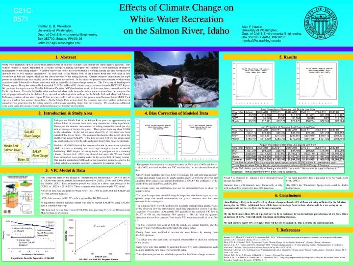
C21C-0571. Alan F. Hamlet University of Washington, Dept. of Civil & Environmental Engineering, Box 352700, Seattle, WA 98195 hamleaf@u.washington.edu. 1. Abstract. 5. Results.

E N D
C21C-0571 Alan F. Hamlet University of Washington, Dept. of Civil & Environmental Engineering, Box 352700, Seattle, WA 98195 hamleaf@u.washington.edu 1. Abstract 5. Results White-water recreation on the Salmon River generates tens of millions of dollars each summer for central Idaho’s economy. This tourism revenue is highly dependent on a healthy snowpack melting throughout the summer to meet minimum streamflow requirements for the rafting industry. A number of previous studies have shown that in a warming climate this vital snowpack will diminish and so will summer streamflows. In areas such as the Middle Fork of the Salmon River this will result in less streamflow in July and August, which are the critical months for the rafting industry. Current estimates approximate that eight percent of scheduled trips are canceled due to low summer streamflows. In this study we project future impacts to white-water recreation in the Salmon River basin, associated with an ensemble of climate change scenarios. The University of Washington’s Climate Impacts Group has statistically downscaled 20 GCMs A1B and B1 climate change scenarios from the IPCC 2007 Report. We use these forcings to run the Variable Infiltration Capacity (VIC) land-surface model to determine future streamflows for the Pacific Northwest. To verify the likelihood of non-boatable days in the future due to low summer streamflows, we compare this suite of projected results for the Salmon River streamflow to historical streamflows for the Middle Fork and Main Fork Salmon. Preliminary analysis shows a two degree Celsius increase could result in a twenty-five percent cancellation of future Middle Fork trips as a result of low summer streamflows. On the Middle Fork section alone this translates into a two million dollar loss in annual revenue generation for the rafting industry, with impacts stretching deeper into the economy. We also discuss additional costs to the users, the tourist economy and potential analysis for other river systems. Effects of Climate Change on White-Water Recreation on the Salmon River, Idaho • Median July Flow decreases 30-34% in the 20’s • Median July Flow decreases 36-41% in the 40’s • Median July Flow decreases 38-40% in the 80’s • Median August Flow decreases 1-6% in the 20’s • Median August Flow decreases 4-10% in the 40’s • Median August Flow decreases 11-18% in the 80’s 2. Introduction & Study Area 4. Bias Correction of Modeled Data Each year the Middle Fork of the Salmon River generates approximately ten million dollars of revenue from week long commercial rafting expeditions. Throughout the summer two commercial rafting companies launch per day with an average of twenty-five guests. These guests each pay about $2,000 for the adventure. In the last ten years about 8% of river trips have been cancelled due to low flows. The common threshold needed is 500 cfs at the Middle Fork gauge (SALYP). If the flow is below 850 cfs, the groups must pay additional costs to fly the rafts and guests twenty-five miles downstream. Hamlet et al. (2005) showed that downward trends in snow water equivalent (SWE) are due to warming and were large enough to create an overall diminishing SWE despite increasing trends in precipitation in a warming climate. Stewart et al. (2005) also showed that across the Western United States streamflow were peaking earlier in the second half of twenty century. This trend in diminishing SWE and earlier streamflow is troublesome for the rafting industry as summer snowmelt is crucial to for summer rafting. Kristian E. B. Mickelson University of Washington, Dept. of Civil & Environmental Engineering, Box 352700, Seattle, WA 98195 kebm1979@u.washington.edu • The quantile bias correction technique discussed in Wood et al. (2002) and Snover et al. (2003) was used to adjust the VIC modeled data to the observed historical data • Observed and simulated historical flows were ranked for each individual monthly average and annual water year to create quantile maps for both the observed and simulated flows using a log normal distribution at SALYP, the confluence of the Middle Fork and Main Fork, and SALMO. • An extreme value one distribution was use for incremental flows to allow for negative flows. • The quantile maps were extended using the respective distribution types to create quantile maps that would accommodate for greater extremes then had been observed in the training data. • The simulated flows were then adjusted to match the corresponding quantile value for the observed flow via interpolation, much like explained in section 3 on data expansion. For example, in August the 50% quantile for the simulated VIC flow at SALYP is 476 cfs, the observed 50% quantile is 688 cfs, with the quantile adjustment the new bias corrected flow for the VIC simulation would be set to 688 cfs. • The bias correction was done at both the month and annual timestep, and the monthly values were then adjusted to match the annual values • Finally flows were modified to account for mass balance by moving from SALMO upstream. • The values were then verified to the original observed flow to check for validation of the process. • Daily flows were then created by adjusting the raw VIC daily simulation for each month to match the new bias corrected month value. • This adjustment process was similarly repeated for the climate change scenarios. 3. VIC Model & Data • The composite mean of the change in Temperature and Precipitation of 20 A1B and 19 B1 GCMs were used to perturb the historical record for 2020’s, 2040’s and 2080’s (Mote and Salathé 2008). Each evaluation period was taken as a thirty year average of the GCMS, i.e. 2020’s is 2010-2039. These scenarios were then run using the VIC model. • Observed Data was available for Water Years 1974-1981 & 2000-2008 for SALYP and for 1920-2008 for SALMO • 96% of the variance in SALYP can be explained by SALMO record • A logarithmic quantile ranking scheme was used to expand SALYP by using SALMO data at a monthly timestep • The historical forcing data covered 1920-2006, thus providing 87 years of Observed and Modeled data for evaluation • SALYP is projected to remain a snow dominated basin through the 2080’s • Summer flows will diminish most dramatically in July, with median flow projected to have 40% reduction • The mean peak flow date is projected to be two weeks early by the 2040’s • By 2080’s late Winter/early Spring levels could be double historic mean 6. Conclusions • June Rafting is likely to be unaffected by climate change with only 10% of flows not being sufficient for the full river journey by the 2080’s. Additional there will be less extreme high flows in June, which could be a net saving as the companies will not have to fly to the downstream putin • By the 2020’s more than 40% of trips will have to fly in customers to the downstream putin because of low fows, this is an increase of 8.5%. This will add to consumer and rafting expenses. • By mid-century nearly 30% of August trips will have to be cancelled. This is double the current amount. • Given a Probability of SALMO 7. References 2. Find Equivalent SALYP Percentile (Interpolate) Hamlet, A. F., Mote P.W, Clark M.P., Lettenmaier D.P., 2005. “Effects of temperature and precipitation variability on snowpack trends in the western U.S.”,Journal of Climate, 18 (21): 4545-456. Mote, P.W., E. P. Salathé, 2009. “Scenarios of Future Climate Change for the Pacific Northwest”, Climatic Change (submitted) Snover, A.K., A.F. Hamlet, and D.P. Lettenmaier, 2003. “Climate change scenarios for water planning studies: Pilot applications in the Pacific Northwest”, Bulletin of the American Meteorological Society 84(11):1513-1518. Stewart, I.T., Cayan, D.R., Dettinger, M.D. “Changes toward Earlier Streamflow Timing across Western North America” Journal of Climate 18 (8): 1136-1155, 2005. Volpert, Bob, Owner & Operator of Idaho River Journeys, Personal Conversation Wood, A. W., E. P. Maurer, A. Kumar, and D. Lettenmaier, 2002, “Long-range experimental hydrologic forecasting for the eastern United States”, Journal of Geophysical Research, 107(D20): 6:1-15. 3. Create new Synthetic SALYP datapoint