Download
1 / 2

E N D
Microphysics and the simulation of MCSs in the TWP.Progress in the representation of Mesoscale Convective Systems (MCS) within cloud-resolving models can only be achieved if the physical reasons for discrepancies between different models are truly understood. DOE scientists at Brookhaven National Laboratory and collaborators performed simulations with three commonly used microphysics parameterizations with varying complexity have been evaluated against satellite-retrieved cloud properties. An MCS identification and tracking algorithm was applied to the observations and the simulations over the Tropical Western Pacific (TWP). Different from many previous studies, these individual cloud systems could be tracked over large distances due to the large domain employed. The analysis demonstrates that MCS simulations is very sensitive to the parameterization of microphysical processes. The most crucial element was found to be the fall velocity of frozen condensate. Differences in this fall velocity between the different experiments were more related to differences in particle number concentrations than to the fall speed parameterization. Microphysics schemes that exhibit slow sedimentation rates for ice aloft experience a larger buildup of condensate in the upper troposphere. This leads to more numerous and/or larger MCSs with larger anvils. Mean surface precipitation was found to be overestimated and insensitive to the microphysical schemes employed in this study. In terms of the investigated properties, the performances of complex two-moment schemes were not superior to the simpler one-moment schemes, since explicit prediction of number concentration does not necessarily improve processes such as ice nucleation, the aggregation of ice-crystals into snowflakes, and their sedimentation characteristics. Reference: K. Van Weverberg, A. M. Vogelmann, W. Lin, E. P. Luke, A. Cialella, P. Minnis, M. Khaiyer, E. Boer, and M. P. Jensen, 2012: “The Role of Cloud Microphysics Parameterization in the Simulation of Mesoscale Convective Systems and Anvil Clouds in the Tropical Western Pacific,” J. Atmos. Sci. (in press),doi: 10.1175/JAS-D-12-0104.1
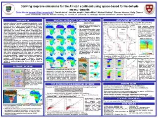
The Role of Cloud Microphysics Parameterization in the Simulation of Mesoscale Convective Systems in the Tropical Western Pacific • Motivation • Improvement of the representation of MCSs within cloud-resolving models can only be achieved if the physical reasons for discrepancies between different models are truly understood. • Approach • Week-long simulations of MCSs were evaluated against satellite-retrieved cloud properties and cloud tracking statistics. Simulations with 3 commonly used microphysics schemes with varying complexity were investigated. • Result • The most crucial element was found to be the fall velocity of frozen condensate. Microphysics schemes with slow sedimentation rates for ice aloft experience a larger buildup of condensate in the upper troposphere, leading to more numerous and/or larger MCSs with larger anvils. Performances of complex two-moment schemes were not superior to the simpler one-moment schemes, since explicit prediction of number concentration does not necessarily improve processes such as ice nucleation, the aggregation of ice-crystals into snowflakes, and their sedimentation characteristics. Snapshots of the spatial distribution of cloud types at 3 UTC on 27 December 2003 as observed by GOES-9 (top left) and as simulated by the three microphysics schemes (clockwise: WSM6, Morrison [MORR] and Thompson [Thom]). Cloud types were defined based on the ISCCP classification technique using cloud-top height and cloud optical depth (cirrus [Ci], cirrostratus [Cs], cumulonimbus [Cb], altocumulus [Ac], altostratus [As], nimbostratus [Nb], cumulus [Cu], stratocumulus [Sc]and stratus [St]). Land masses are grey. Thick black contours denote those cloud fields identified as mesoscale convective systems. Latitudes and longitudes are indicated by the numbers in the margins. K. Van Weverberg, A. M. Vogelmann, W. Lin, E. P. Luke, A. Cialella, P. Minnis, M. Khaiyer, E. Boer, and M. P. Jensen, 2012: “The Role of Cloud Microphysics Parameterization in the Simulation of Mesoscale Convective Systems and Anvil Clouds in the Tropical Western Pacific,” J. Atmos. Sci. (in press), doi: 10.1175/JAS-D-12-0104.1