Download
1 / 1
10 likes | 119 Views
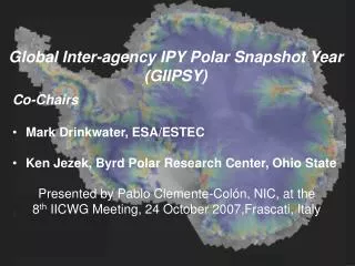
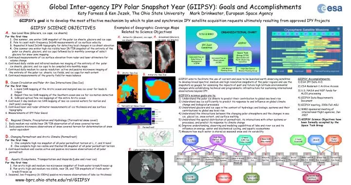
C-band SAR fine 3-day repeat. C-Band SAR 3day repeat. GRACE. A. A. Antarctica. Greenland. C-band ScanSAR. Global Inter-agency IPY Polar Snapshot Year (GIIPSY): Goals and Accomplishments Katy Farness & Ken Jezek, The Ohio State University Mark Drinkwater, European Space Agency.

E N D
C-band SAR fine 3-day repeat C-Band SAR 3day repeat GRACE A A Antarctica Greenland C-band ScanSAR Global Inter-agency IPY Polar Snapshot Year (GIIPSY): Goals and Accomplishments Katy Farness & Ken Jezek, The Ohio State University Mark Drinkwater, European Space Agency GIIPSY’s goal is to develop the most effective mechanism by which to plan and synchronize IPY satellite acquisition requests ultimately resulting from approved IPY Projects • GIIPSY SCIENCE OBJECTIVES • A. Sea Level Rise (Glaciers, ice caps, ice sheets) • For the first time • 1. One summer, one winter SAR snapshot of the polar ice sheets, glaciers and ice caps. • 2. Pole to coast multi-frequency InSAR measurements of ice surface velocity • 3. Repeated X-band InSAR topography for detecting local changes in ice sheet elevation • 4. One summer one winter high res visible/near IR/TIR snapshot of the entirety of the • polar ice sheets, glaciers, and ice caps followed by bi-monthly coverage of select • glaciers for snow-zone mapping • 5. Continued measurements of ice surface elevation from radar and laser altimeters for • volume change • 6. Continued daily visible and infrared medium-res imaging of the entirety of the polar • ice sheets, glaciers, and ice caps to be compiled into monthly maps • 7. Continued daily medium to coarse resolution active and passive microwave imaging of • the entirety of the polar ice sheets, ice fields, and ice caps for melt extent • 8. Continued measurements of the gravity field for mass balance • B.Ocean Circulation and Polar Air-Sea Interactions (Sea Ice) • For the first time • 1. L-band SAR mapping of the Arctic ocean and marginal sea ice cover for leads & • ridges • 2. Repeat fine res SAR mapping of the Southern ocean sea ice for ice motion detection • 3. SAR and optical fine res mappings of the entire Arctic ocean • 4. Continued 3-day medium res SAR mapping of sea ice covered waters for motion and • melt pond coverage • 5. Continued laser and radar altimeter measurements of ice thickness and sea surface • topography • 6. Measurements of IPY Polar Geoid • C. Regional Climate, Precipitation and Hydrology (Terrestrial snow cover) • Daily medium res visible/near IR/TIR observation of all snow covered terrain • Daily passive microwave observations of snow covered terrain for determination of snow • water equivalent • D. Changing Permafrost and Arctic Climate (Permafrost) • For the first time • 1. One complete high res snapshot of all polar permafrost terrain at L, C, and X band • 2. One complete high res visible and thermal IR snapshot of all polar permafrost terrain • 3. Continued medium and coarse active and passive microwave observations of all polar • permafrost • E. Aquatic Ecosystems, Transportation and Hazards (Lake and river ice) • For the first time • 1. Pan-arctic high and medium res microwave snapshot of fresh water-break/freeze-up • 2. Pan-arctic high and medium res visible, near IR, and TIR snapshots of fresh water- • break/freeze-up • 3. Seasonal, low-frequency (6-10GHz) passive microwave observations of lake ice thickness Examples of Geographic Coverage Maps Related to Science Objectives ORGANIZATIONAL CHART ICSU & WMO A. Greenland (Glaciers, ice caps, ice sheets) A. Antarctic (Glaciers, ice caps, ice sheets) GIIPSY IPY Joint Committee Space Task Group (STG) Operational and Earth Observing Satellites Subcommittee on Data Policy & Management SCDPM Subcommittee on Observations SCOBS B. Arctic Sea Ice SAR Mission Planning Group High Res Optical, IR, TIR High-Res Optical Mission Planning Group Laser Radar Altimeters SAR L, X, C Band GIIPSY Accomplishments: 1) ESA IPY Data A.O. 2) CSA Radarsat-1 Archive Access 3) U.S. NASA and NSF funds for ALOS processing 4) GIIPSY Data Requirements Document 5) GIIPSY meeting, 2006 Fall AGU 6) WMO sponsored meeting of international flight agencies, Jan 2007 7) GIIPSY Science Objectives have been formally accepted by the Space Task Group • GIIPSY aims to facilitate the use of current and soon to be launched earth observing satellites to develop broad spectral, medium and high resolution snapshots of the polar regions and use the snapshots as gauges for assessing the impacts of past and future high latitude environmental changes while establishing technical and programmatic infrastructure for sustaining international observations beyond IPY. • GIIPSY’s science goals are to: • Understand the polar ice sheets to predict their contribution to global sea level rise • 2) Understand sea ice sufficiently to predict its response to and influence on global climate change and biological processes • 3) Understand glaciers and ice caps in the context of hydrologic and biologic systems and their contributions to global sea level rise • 4) Understand the interactions between the changing polar atmosphere and the changes in sea ice, glacial ice, snow extent, and surface melting • 5) Understand the spatial distribution of permafrost, its interactions with other systems or processes, and predict its response to climate change • 6) Improve understanding, observing and modeling capabilities of lake and river ice and its influence on energy, water and biochemical cycling, and aquatic ecosystems • 7) Measure how much water is stored as seasonal snow and its variability B. Antarctic Sea Ice A C B A D E B B E C Arctic Lakes & Rivers Freeze-up Break-up Polar Land & Sea Ice Snow Cover Canadian Ice Cap Svalbard Iceland Antarctic Sea Ice Arctic Permafrost Global Sea Ice Covered Water Terrestrial Ice Cover Arctic Lakes and Rivers Arctic Sea Ice Permafrost Extent C. Terrestrial Snow Cover Moderate Res pmWave, Optical & IR L-Band SAR 2 45 day cycles InSAR L, X, C Band Hi Res Optical D. Permafrost E. Lake and River Ice www-bprc.ohio-state.edu/rsl/GIIPSY