Download
1 / 21
250 likes | 347 Views
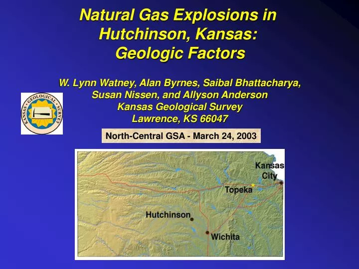
Natural Gas Explosions in Hutchinson, Kansas: Geologic Factors W. Lynn Watney, Alan Byrnes, Saibal Bhattacharya, Susan Nissen, and Allyson Anderson Kansas Geological Survey Lawrence, KS 66047. North-Central GSA - March 24, 2003. Summary.

E N D
Natural Gas Explosions in Hutchinson, Kansas: Geologic Factors W. Lynn Watney, Alan Byrnes, Saibal Bhattacharya, Susan Nissen, and Allyson Anderson Kansas Geological Survey Lawrence, KS 66047 North-Central GSA - March 24, 2003
Summary • Gas leaked from hole in casing at 595 ft depth in S-1 gas storage well • Gas encountered in vent wells at depths ranging from 420 ft (Yaggy) to 240 ft below surface (eastern Hutch) • Gas zone confined to 15-ft thick interval • three thin (2-3 ft) beds of dolomicrite • Gas zone is located at the top of Lower Permian Upper Wellington Shale • Vent wells closely follow crest of narrow, low-relief, asymmetric, northwesterly-plunging anticline • Fractures/joints trending along crest of structure appear to be responsible for gas migration between Yaggy and Hutchinson
Geological Data • Completion data and wireline logs from 54 vent and observation wells in and around Hutchinson • 2 cores along Wilson Road between Hutchinson and Yaggy Gas Storage Facility • Core (Q-5) and log data from Yaggy Gas Storage Facility • Core from AEC #1 Test Hole in Lyons, Co. (20 mi NW of Hutchinson) • Archived strat/sed database encompassing Lower Permian Stone Corral Formation to Top Chase Group • Surface exposures • Integration with seismic and engineering data
Locations of explosion sites, geysers, and areas of known subsidence in Hutchinson Trailer Park Explosion site Evacuated area near geysers & explosion site Downtown explosion site Area of subsidence 1 mile From Interactive KanView ESRI MapServer at Kansas Geological Survey (www.kgs.ukans.edu)
Casing Leak Index map 2 mi.
Well log showing major geologic strata important in Hutchinson incident Land Surface Previously mapped intervals from Watney et al. (1988) - (archived data) Primary gas-bearing interval 200 ft Secondary gas interval (DDV #64 in 3-day blow-out in July, 2001) Stratigraphic location of casing leak Nickerson Well location Solution mining and gas storage Wilson Road Seismic Line Yaggy Hutchinson Gamma Ray Neutron
gypsum dolomite subaerial Exposure surface dolomite Bed “B” dolomite clasts Core from DDV #67 3-finger dolomite interval Bed “C” 1 feet Base 3-fingers dolomite interval
1.5 ft thick jointed dolomite overlying silty shale • Upper Wellington Shale • Hammer for scale • Afton Lake spillway, western Sedgwick County • (40 mi SE of Hutchinson) Dolomictrite bed
Orthogonal NW-SE and NE-SW trending joints along the upper surface of the dolomite at Afton Lake spillway
Data from IMC Salt Co., Hutchinson provided by J. Radigan A B C
Yaggy Gas Storage Hutchinson Wilson Road seismic line Arkansas River Valley Embayment along eastern edge of Hutchinson Salt subcrop (dissolution front) 5 miles no salt salt
North-South Autocorrelated Structural Cross Section Color Gamma Ray Increasing Shale Content 2 miles 100 feet 3-finger dolomite interval A B C truncation and thinning of upper salt bed Hutchinson Salt
West-to-East Autocorrelated Structural Cross Section Color Gamma Ray 2 miles Q-5 at Yaggy 100 feet Equus Beds 3-finger dolomite interval Upper dolomite bed A B C Hutchinson Salt
Wilson Road Seismic Line
OB #2 Adjacent to Yaggy 2 miles
Halliburton’s Electro Micro Imager w/Sonic • Observation Well OB #2 • Highest recorded pressure, 250 psi • Adjacent to Yaggy Gas Storage Facility Image Raw N E S W N Degrees dip 0 20 40 60 Image Dynamic N E S W N • Bulk density • Density porosity • Density Correction • Photoelectric Partial fractures A B C Gas zone cased and perforated 409-412 ft • GR • Caliper Partial fractures Sonic DT 240 40
PSI Hutchinson Yaggy Feet
Basic Volumetrics Fracture Cluster Volume Length – 8.7 mi (14 km) Width – 1,000 ft (300 m) Height – 3 ft (0.9 m) Porosity – 2% Fracture Volume = 2.8 Mcf (78,000 m3) Estimated Volume of Gas Released = 143 Mscf = 3.5 Mcf (at 600 psi, 54 oF)
Rough estimate of gas flow (cubic feet per day) associated with various fracture widths at various fracture widths Joint traces along the upper surface of dolomite Well that intercepts fracture system could vent gas over several days. Back of the envelope Flow Calculation Assumptions: 1) Continuous, 3-ft long, homogeneous fracture over entire 46,000 feet (8.7 mi) 2) 600 psi pressure maintained over entire length of fracture to venting location
Summary • Gas leaked from hole in casing at 595 ft depth in S-1 gas storage well • Gas encountered in vent wells at depths ranging from 420 ft (Yaggy) to 240 ft below surface (eastern Hutch) • Gas zone confined to 15-ft thick interval • three thin (2-3 ft) beds of dolomicrite • Gas zone is located at the top of Upper Wellington Shale • Vent wells closely follow crest of narrow, low-relief, asymmetric, northwesterly-plunging anticline • Fractures/joints trending along crest of structure appear to be responsible for gas migration
Persistent Lineament in during deposition of Hutchinson Salt corresponding to Precambrian terrane boundary Percent Halite Hutchinson Salt Net Halite Upper Hutchinson Salt Total Net Halite Hutchinson Salt Watney et al. (1988) Hays Hutch Wichita Net Halite Lower Hutchinson Salt