Download
1 / 91
1.08k likes | 1.53k Views
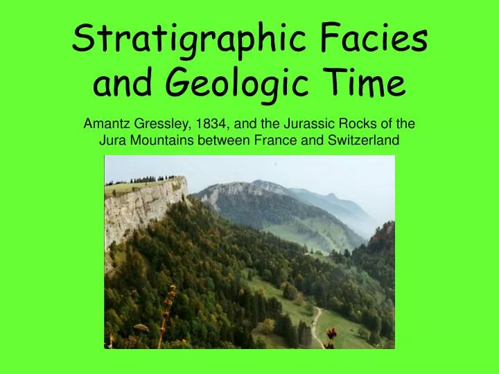
Stratigraphic Facies and Geologic Time. Amantz Gressley, 1834, and the Jurassic Rocks of the Jura Mountains between France and Switzerland. The Interpretation of Geologic History Requires Knowledge of the Following. The Interpretation of Sedimentary Rocks Requires Knowledge of the Following:.

E N D
Stratigraphic Facies and Geologic Time Amantz Gressley, 1834, and the Jurassic Rocks of the Jura Mountains between France and Switzerland
The Interpretation of Geologic History Requires Knowledge of the Following The Interpretation of Sedimentary Rocks Requires Knowledge of the Following: 1. Sedimentary Rocks • Rock Classification 2. Igneous Rocks 2. Depositional Environments 3. Metamorphic Rocks 3. Sedimentary Structures 4. Origin and History of Life 4. Sedimentary Tectonics 5. Tectonics, including: 5. Sedimentary Facies and Time • Structural geology • Plate tectonic theory • Etc. The core concept is tectonics since nothing in geology makes sense except in the light of tectonics
Abraham Gottlob Werner’s Geologic Time Scale The Neptunist World View Sea Level after deposition of the Primitive rocks Transition Sea Level after deposition of the Transition rocks Stratified Primitive Sea Level after deposition of the Stratified rocks Transported Primitive – crystalline rocks, both igneous and metamorphic. Thought to represent first chemical precipitates from a worldwide ocean. Transition – stony, indurated stratified rocks such as graywacke, limestones, sills. Stratified – obviously stratified fossiliferous rocks, thought to represent the first deposits after receding of the worldwide oceans, formed by erosion of emergent mountains. Transported – Poorly consolidated clays, sands and gravels. Thought to have been deposited after final withdrawal of a worldwide ocean. Volcanic – Younger lava flows associated with volcanic vents (added to the classification later as an afterthought, lavas were thought to be local phenomena resulting from the burning of coal beds.
Layer Cake Stratigraphy The study of rock strata, especially the distribution, deposition, and age of sedimentary rocks P 126 Werner’s theory made a firm prediction, that the same kinds of rocks should have been laid down in the same sequence all over the world.
The Facies Concept It is not certain who first noticed that rocks were not layer cake. Levoisier in 1789 is the earliest mention we have, but Amantz Gressley coined most of the important concepts while working in the Jura Mountains. While describing the rocks he observed lateral changes in the composition and described them with clarity calling these changes facies. But, then later in his paper he spoke of facies changes “in the vertical direction” meaning that the rocks were different vertically as well as horizontally. This has led to ongoing confusion. Perhaps a dozen different concepts and definitions about the facies have been proposed. But, they all go back to the two original ways Gressley used the term – his formal definition, and his offhanded use of the term.
Two Facies Definitions Definition One The facies is the sum total of all the physical, biological and chemical characteristics imparted to a sedimentary rock at the time of deposition. Definition Two Facies are the many different sediments and resulting rocks that form at the same time, but in different depositional environments.
The Transition from Wernerian "Transition Rocks" To the Lower Paleozoic Periods By Sedgewich and Murchinson Murchinson, 1835 Charles Lapworth 1879 Ordovician Silurian Sedgewick, 1835 Murchinson, 1835 Cambrian Silurian Sedgewick, 1835 Cambrian overlap Opps !
Pleistocene Pliocene Miocene Eocene Lyell 1833 Cretaceous D’Halloy 1822 Jurassic Gressley 1795 Triassic Alberti 1834 Permian Murchinson 1841 Pennsylvan. Williams 1891 Carbonif. Mississippian Williams 1891 “Old Red ss” Devonian Sedgewich & Murchinson 1839 Murchinson 1835 Silurian Unstudied Until 1830’s Lapworth 1879 Ordovician Sedgewick 1835 Cambrian
The Transition from Wernerian "Transition Rocks" To the Lower Paleozoic Periods By Sedgewich and Murchinson Adapted from Dott and Batten: Evolution of the Earth
Old Red Sandstone Early Devonian fishes from the Old Red Sandstone of Spitzbergen (Wood Ray Formation) http://www.picturescape.co.uk/gallery%20pages/gallery%20one/caldey%20sandstone.htm http://www.picturescape.co.uk/gallery%20pages/gallery%20one/caldey%20sandstone.htm
Old Red Sandstone The Old Red Sandstone exhibited many changes over short distances, with thinly layered areas alternating with conglomerates and outstanding crossbedded sandstones. http://virtual.yosemite.cc.ca.us/ghayes/Siccar%20Point.htm
Devonian Marine Rocks of Devon, England The cliffs at Fremington are Devonian with Glacial beds on top of this, below the Devonian beds follows the carboniferous beds. Both Upper and Lower Carboniferous rocks have been found at Fremington, however it is suspected that some of these rocks have drifted from up or down stream, this could explain why occasionally blocks of Carboniferious limestone can be found. http://www.ukfossils.co.uk/sec084c.htm
Devonian Marine Rocks of Devon, England http://www.earthfoot.org/places/uk005.htm
After their work on the Cambrian and Ordovician – but before they had their falling out over the overlap of their systems – Sedgewick and Murchinson decided to tackle the problem of the Old Red Sandstone and the marine bearing rocks of Devonshire exposed on opposite sides of Bristol Bay. Wales Bristol Bay Devonshire http://www.devonshireheartland.co.uk/ http://www.camelotintl.com/heritage/counties/england/devon.html
Scenes of Devonshire, England http://www.picturesofengland.com/Devon/pictures-1.htm
Scenes of Devonshire, England http://www.picturesofengland.com/Devon/pictures-1.htm
The Problem There are different rocks sandwiched between the Silurian and Carboniferous rocks as found in Wales and Devonshire.
Transgression Onlap (Transgressive) Sequences Shifting Facies through Time Time Rock Unit Time Rock Unit Time Rock Unit Time Transgressive Unit Time Rock Unit Time Rock Unit Time Rock Unit Beach sandstone Near Shelf shale Far Shelf limestone Beach moves farther away Water gets deeper Sediment becomes finer FUS – Fining Upward Sequence = Transgressive Sequence
Prograding Regression Offlap (Regressive) Sequences Shifting Facies through Time Time Transgressive Rock Unit Beach sandstone Time Rock Unit Time Rock Unit Time Rock Unit Time Rock Unit Time Rock Unit Near Shelf shale Far Shelf limestone Beach moves closer Water gets shallower Sediment gets coarser CUS – Coarsening Upward Sequence = Regressive Sequence
Beach sandstone Time Transgressive Rock Unit Near Shelf shale Far Shelf limestone Beach sandstone Prograding Regression Beach moves farther away Near Shelf shale Water gets deeper Far Shelf limestone Sediment becomes finer Transgression Beach moves closer Water gets shallower Sediment gets coarser Transgressive Sequence Regressive Sequence
A couple of hundred miles There are Facies, and then there are Facies The facies is the sum total of all the physical, biological and chemical characteristics imparted to a sedimentary rock at the time of deposition. Facies Two Facies One Facies are the many different sediments and resulting rocks that form at the same time, but in different depositional environments.
The Problem There are different rocks sandwiched between the Silurian and Carboniferous rocks as found in Wales and Devonshire. FUS CUS FUS CUS FUS CUS
Transgressive Sequence in the Grand Canyon of Arizona TONTO GROUP Cambrian Period, 500-520 Million Years Old, 1025 Feet Thick Yellowish ledges on top, the Tonto Platform between, and brown cliff below COARSENING UPWARD SEQUENCE http://www.canyondave.com/TontoPg.html
Transgressive Sequence Shown above is an example of a prominent transgressive surface, combined with a sequence boundary. This surface separates underlying shallow subtidal carbonate from overlying deep subtidal carbonate and mudstone. Note the pyritization, visible as a rusty stain, at this surface. Photograph taken at the contact between the Upper Ordovician Carters Limestone (below) and Hermitage Formation at the Nashville International Airport. This outcrop has subsequently been removed and is no longer visible. http://www.uga.edu/~strata/sequence/transgressivesurface.html
Transgressive Sequence The next example of a transgressive surface separates underlying shallow subtidal carbonate from overlying offshore mudstone. Photograph taken at the basal contact of the Nolichucky Formation in southwestern Virginia.
Transgressive Sequence http://www.bees.unsw.edu.au/future/geology.html
Regressive Sequence Table mountain near Mitzpe Ramon, central Negev, Israel http://www.geomorph.org/gal/mslattery/world.html
Regressive Sequence http://www.geneseo.edu/~gsci/pages/department/information/brochure/brochure_department.html
Transgressive-Regressive Sequences http://www.geology.utoronto.ca/basinanalysis/photos.htm
Universality 53 Properties of Complex Evolutionary Systems Fractal Organization – Sea Level Changes
Universality 53 Properties of Complex Evolutionary Systems Fractal Organization – Sea Level Changes patterns, within patterns, within patterns
Graph to left takes up Only this much time on the Above graph Relative Sea Level Curves
3rd order down, 4th order up; muted sea level fall 3rd order up, 4th order down; muted sea level rise 3rd order up, 4th order down; muted sea level rise Both curves go down; exaggerated sea level fall Relative Sea Level Curves and Constructive and Destructive Interference
Sea Level Changes and Corresponding Trangressions/Regressions are Fractal Third Order Transgression . . . followed by . . . A Third Order Regression
Sea Level Changes and Corresponding Trangressions/Regressions are Fractal Third Order Transgression . . . followed by . . . A Third Order Regression 4th Order Regression . . . followed by . . . 4th Transgression. . . followed by . . . 4th Regression . . . followed by . . . 4th Transgression followed by . . . 4th Regression
Sea Level Changes and Corresponding Trangressions/Regressions are Fractal FUS CUS FUS CUS Figure 8 shows upward and seaward increase in depositional energy (yellow dotted and green areas), which is tied to increases in porosity and permeability. The basal disconformity (wavy line) is the horizontal datum for the 3-D porosity and permeability models. The wedge shape of the Sussex "B" interval results from reworking by currents of seaward margins of sand ridges, and landward redeposition of sediment. The blue-lined areas are basal and landward low-depositional-energy facies; these exhibit low porosity, permeability, and petroleum production. The disconformity at the top of the Sussex "B" sandstone is generally marked by a thin chert-pebble sandstone (figure 9A). Shading variation of the quartz (figure 9B) results from fracturing of the grain in this cross-nicols photomicrograph view (light is transmitted differently due to rotation of the crystal axes). Quartz grains that were incorporated from underlying sand-ridge sediments commonly exhibit early stages of diagenesis within marine environments, primarily chamosite overgrowths under the quartz overgrowths. Grain-to-grain contacts within this facies are mainly point with lesser long-straight contacts. http://pubs.usgs.gov/dds/dds-033/USGS_3D/ssx_txt/depomod.htm
Correlation Demonstrating the Equivalency of Stratigraphic Units
Equivalency may mean: Lithologic: Same rock unit Paleontologic: Contain same fossils Time: Deposited at same time Biostratigraphic Facies # 2 Facies are the many different sediments and resulting rocks that form at the same time, but in different depositional environments. Facies # 1 Facies are the many different sediments and resulting rocks that form at the same time, but in different depositional environments.
1. Ways of Correlating - Lithologic “Walking Out” Physically tracing a bed from one place to another to insure it is in fact the same rock unit; literally “walking it out.” Or, tracing an outcrop down the highway. Can be done in many places in the west where good exposure, and flat lying beds are easy to trace.
Grand Canyon of Arizona http://www.mongabay.com/external/grand_canyon_trouble.htm http://www.ggl.ulaval.ca/personnel/bourque/s4/cambrien.pangee.html http://www.raphaelk.co.uk/main/worldwonders.htm
The problem is, . . . Rocks are not always flat laying, and traceable at the surface. A cross section through the Harrisonburg and Bridgewater, Virginia area, showing a duplex “herd of horses.” The floor thrust is at the bottom of the drawing just above the basement rocks. The North Mountain fault is the roof thrust. In between are a series of splay faults that isolate a series of horses. Note the overturned anticline on the far left (west) side where the last ramp formed. From Gathright and Frischmann, 1986, Geology of the Harrisonburg and Bridgewater Quadrangles, Virginia.
2. Ways of Correlating - Lithologic “Key Beds” Correlating by recognizing and identifying beds that are so distinctive you always know them when you see them. 1. Distinctive lithology 2. Distinctive mineral assemblage. 3. Particular sedimentary structures.
“Key Beds” The Chattanooga Shale http://www.uta.edu/paleomap/homepage/Schieberweb/summer_2000_field_work.htm
“Key Beds” The iridium layer at the K-T boundary An analysis of the chemical composition of this clay layer shows that it contains a relatively high concentration of an element called iridium. Iridium is rare in the Earth’s crust, but more common towards the Earth's centre, and in space. It continually filters down to earth from outer space, and so a high concentration of iridium is usually an indication that the sediment was deposited very slowly, absorbing lots of iridium over time. http://www.bbc.co.uk/beasts/whatkilled/evidence/analyse1.shtml http://c3po.barnesos.net/homepage/lpl/fieldtrips/K-T/day3/day3.html
http://www.athro.com/geo/trp/ktm/ktmain.html The hill in the background of this photograph is known as Iridium Hill. The bands on the side of the hill are layers of rock of different ages that span the time of the extinction of the dinosaurs. http://www.uhaul.com/supergraphics/crater/what-is-it2.html http://www.student.oulu.fi/~jkorteni/space/boundary/