Download
1 / 29
290 likes | 353 Views
Watershed Dynamics. Bill Carlsen Penn State University. Authentic Inquiry. Learning science “as science is practiced” Real questions with unknown answers Important problems (often local ) Socially constructed through collaboration, argumentation, and critical evaluation by peers. Poll 1.

E N D
Watershed Dynamics Bill Carlsen Penn State University
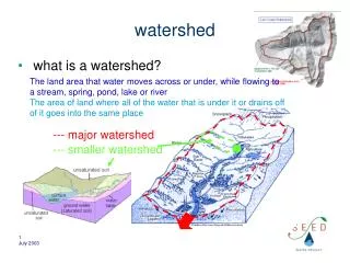
Authentic Inquiry Learning science “as science is practiced” • Real questions with unknown answers • Important problems (often local) • Socially constructed through collaboration, argumentation, and critical evaluation by peers
Object Recognition Using Airphotos • “Guide to Mostly On-Line and Mostly Free U.S. Geospatial and Attribute Data” (updated URL, p. 76) • http://libinfo.uark.edu/GIS/US.asp • ExpressView Browser Plug-in (MrSID) for .SID files • http://www.lizardtech.com/download/
Reviewing Airphotos • Common formats: TIFF, SID, various GIS • Metadata files provide information on type of image, scale, location, year and season, coordinates, corrections, etc.
Metadata Originator: USDA-FSA Aerial Photography Publication Date: 20041228 Title: NAIP 1-meter resolution mosaic of Centre County, Pennsylvania Abstract: This data set contains imagery from the National Agriculture Imagery … Format Information Content: MrSID Transfer Size: 333.747
Key Indicators 1. Tone - gray scale 2. Texture - tonal repetitions 3. Pattern - spatial arrangement of objects 4. Size - dimensions of object 5. Shape - conformation, configuration 6. Shadow - a clue to size and shape 7. Location – what’s nearby?
Test Your Remote Sensibility • What are the structures at D? • What direction is the water flowing? • What famous movie scene was filmed at F?
Links “Guide to Mostly Free Geospatial Data” http://libinfo.uark.edu/GIS/US.asp ESRI ArcExplorer free download www.esri.com/software/arcexplorer/ Environmental Inquiry Project http://ei.cornell.edu http://ei.ed.psu.edu
NSTA Web Seminar Evaluation http://institute.nsta.org/survey/wdSurvey1.asp
Upcoming NSTA Web Seminars: • Picture-Perfect Science I • December 14, 2005 • Picture-Perfect Science II • January 11, 2006 • NASA: Preparing for the Journey to Space II • January 19, 2006 • 6:30 PM Eastern Time