Download
1 / 15
170 likes | 477 Views
Watershed Delineation. 9-12-07. Caney Fork Watershed. 05130108 – HUC8 Cat Number

E N D
Watershed Delineation 9-12-07
Caney Fork Watershed • 05130108 – HUC8 Cat Number • Copy folder from classfiles\GEOG4650-Li\Data\caney-dem to your own folder. You will start working on the layer from your own folder. Be careful when you copy folder from one place to another. DO NOT MOVE, use COPY. • Start a new ArcMap project or use the existing project and add a new Dataframe to the TOC. • While adding 05130108 to your project, you will be asked to perform “Create pyramid for 05130108”, simply click “Yes” then, sit and wait……..Z Z Z Z Z Z Z Z Z………
05130108 • Is the layer projected? • If not, what is the datum used for the layer? (from Properties / Sources) • How to project DEM from DD to ? • Let’s look at the elevation data – we found that the elevation ranges from 13522 to 67699. • It seems to be a ????? Unit • From Properties / Sources.. We found that the Pixel Type is “unsigned integer” • So, you need to change it back to ????? • Let’s use Spatial Analyst | Raster Calculator • And you may get a “Calculation”, right-click on the Calculation | Data | Make Permanent
Project DEM • ArcToolBox • Data Management Tools • Projections and Transformations • Raster • Project Raster (Remember to create a new folder to hold the projected DEM) Create a new dataframe and move the projected DEM to the new dataframe
Nonprojected vs Projected • Nonprojected vs projected
Watershed Delineation • Use ArcToolBox • Spatial Analyst Tools • Hydrology • Fill (Why?) and this process will take forever to complete (at least on my computer), then • Flow Direction and Flow Accumulation
Caney-HUC-12 • Add “Caney-HUC-12.shp” to the current dataframe. (make sure the fill pattern is set at transparent so your flow accumulation layer can be seen under HUC layer). • We will dissolve features (HUC-12) into HUC-10 based on criteria from the table. • Let’s open up the attribute table and decide what attributes to be remained on the new attribute table.
Dissolve Features • ArcToolBox • Data Management Tools • Generalization • Dissolve • Keep these: • Area • Name 10 • Grassacre • HUC_10 • HUC_8 • HUC_6 • HUC_4 • HUC_2 • Statistics Fields: • AREA: SUM • GRASSACRE: SUM • Name of new shape: • Caney_huc_10.shp (underline, instead of hyphen)
HUC-10 • There are 9 HUC-10 watersheds in the Caney.
Create Pour Points • PourPoint.shp (UTM1983) • Find 9 points at the outlets of each HUC-10 watersheds and create them. • Use spatial join to join attributes from Caney_huc_10.shp to PourPoint.shp
Spatial Join –Table formed • Table’s attribute joined from other layer based on spatial relationship.
Spatial Analysis Tool • Hydrology | Watershed Problem: ????? DEM or Fill Sink process is not detailed enough..
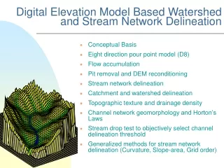
Create 3D Model • Start ArcScene from ArcGIS • Add Caney-dem-de to the project • Set “Base Height” from the layer’s properties. • You may have to exaggerate 20 times for your Z scale.