Download
1 / 49
720 likes | 1.6k Views
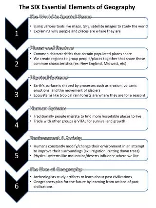
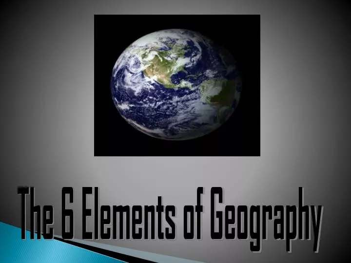
The 6 Elements of Geography. 6 Elements. Many geographers use the six essential elements to organize their study. 1. The World in Spatial Terms 2. Places and Regions 3. Physical Systems 4. Human Systems 5. Environment and Society 6. Uses of Geography. The World in Spatial Terms.

E N D
6 Elements Many geographers use the six essential elements to organize their study. • 1. The World in Spatial Terms • 2. Places and Regions • 3. Physical Systems • 4. Human Systems • 5. Environment and Society • 6. Uses of Geography
The World in Spatial Terms • Geography is the study of the special physical and human characteristics of a place or region. • An important part of geography is the relationship between humans and their environment. • A geographer may study culture (or a learned system of shared beliefs, traits, and values).
The World in Spatial Terms • Geographers look at where things are on the Earth’s surface. • Changes in settlement patterns over time are also important.
The World in Spatial Terms • Geographers use many tools in their studies, including maps, charts, and graphs. They also use field notes, interviews, photographs, reference books, and videos • High-tech tools such as satellites provide detailed images of the Earth • Computer databases, like Geographic Information Systems, (GIS) store huge amounts of data. Satellite image of Texas, Louisiana and the Gulf of Mexico
Latitude, Longitude, and Location
The World in Spatial Terms It also tells us where this place is in relation to other places? • Absolute Location: The exact latitude and longitude or address of a place. (1234 Huntington Lane) • Relative Location: The location of a place in relationship to other locations (around the corner from Krogers)
Lines of Latitude (A.K.A. parallels) -measure distance north or south of Equator 1. Equator = 0* (divides earth into northern & southern hemispheres) 2. Poles = 90* N or S 3. Tropics = 23 ½* N or S 4. Circles = 66 ½* N or S
Lines of Longitude (A.K.A. meridians) -measure distance east or west of the Prime Meridian 1. Prime Meridian = 0* -former site of Royal Observatory in Greenwich, England 2. International Date Line = 180* E
Time Zones -Earth takes 24 hours to rotate, & it is divided into 24 parts for keeping time (time zones) *Each time zone = about 1,000 miles E to W at the Equator. *When you cross a time zone going east, then you set your watch ahead one hour. *When you cross a time zone going west, then you set your watch back one hour.
Map DISTORTION *every map projection stretches or breaks the curved surface of Earth in some way as it is flattened *distance, direction, shape, or area may be distorted *Describe the negative and positiveattributes of the following maps:
T.O.D.A.L.S.I.G.S. The acronym TODALSIGSs defines nine essential elements to help map users get the most information from a map.
Title -first thing you should look at
Orientation -refers to directions -shown by compass rose (Or Star) *cardinal directions = N, S, E, & W *intermediate directions = NW, NE, SW, & SE
Date & Author -date helps us judge accuracy of the map -date usually down here too
Legend (Key) -list that explains symbols in the map
Scale -shows relationship between map measurements and actual distances
Index -alphabetical list of places shown on a gridded map or set of maps (gives addresses of places listed)
Grid -set of intersecting lines (parallels and meridians)
Source & Surrounding Places -used if information not obtained by direct experience or observation -identifies places or features that border the area depicted on a map • If you were looking at a map of the US, you would see Canada and Mexico labeled, but you may not see any detail at all.
Using Scale • small scale maps -large area with little/small detail
2. large scale maps -small area with great/large detail
A. General-Purpose Maps • Physical Maps – show topography (shape) of earth’s physical features • Political Maps – show boundaries between countries WE WILL TAKE A CLOSER LOOK AT DIFFERENT GENERAL AND SPECIAL PURPOSE MAPS LATER ON.
Places and Regions • A place has physical and human characteristics that make it special. • Physical characteristicsinclude animal and plant life, sources of water, climate and weather, landforms and soils. Palo Duro Canyon
Places and Regions • Landforms are the natural shapes on the Earth’s surface, such as mountains, hills, and valleys. Enchanted Rock State Park
Places and Regions • Human characteristics include ethnicity, language, political and economic systems, population distribution, religion and standard of living. Regions in Texas
Places and Regions: • Think of your favorite city, state, or country. • Describe it. • How have the physical characteristics of this place influenced the people there?
Places and Regions • A region is an area with common characteristics that make it different from surrounding areas. • A formal region has one or more share characteristic, such as plant life or can be cultural, economic or political. • Countries, states and cities are examples of formal political regions. Downtown Dallas
Places and Regions • A functional region is made up of different places that function together as a unit…such as a metropolitan area such as Dallas-Ft. Worth. • Perceptual regions are defined by people’s shared attitudes, culture and feelings about an area. Central Texas and the Panhandle have vague borders. The Cadillac Ranch Amarillo, Texas The Texas Panhandle
Physical Systems • Geographers study the physical processes and interactions among four physical systems – Earth’s atmosphere, land, water and life. • Physical processes shape and change Earth’s physical features and environments. • Climate and weather affect humans.
Physical Systems • An ecosystem is all of an area’s plants and animals together with the nonliving parts of their environment. • Earth is the largest ecosystem. • Natural events and human activity can change ecosystems. • Studying physical processes and ecosystems because the environment is the setting for all life on Earth.
Physical Systems: • How did Hurricane Katrina influence New Orleans’ population and economy?
Human Systems • Studying human systems such as population distribution, growth and movement helps in understanding human events and geography. • Population growth is affected by a population’s age, birthrate, death rate, and life expectancy. • Changes in human activity such as advances in medical care and food production have led to population growth.
Human Systems • Geographers look at where people live and how crowded a region or place is when they study place population density. • They also study migration or the movement of people. • One specific type of movement is urbanization, which is an increase in people living or working in cities. Houston, Texas traffic
Human Systems • Many geographers study the features of cultural groups. • People often create groups that separate, organize, or unify areas. • Geographers also consider human systems of communication, trade and transportation in the global community. Southwest Airlines Jet at Dallas Love Field
Environment and Society • One of the most important topics in geography is how people interact with the environment. • Human activities can have positive and negative affects on the environment. Pollution in Houston, Texas on a clear day.
Environment and Society • The environment affects humans as well. • Physical features such as landforms and rivers can influence where people live, and people depend on the environment for survival. • Human life requires three basic resources: air water land. Padre Island, Texas
Environment and Society • Other materials such as wood, coal and oil are also important resources. • As the world population grows, demands on resources increase. • Geographers study the locations, quality and quantity of Earth’s resources and the effect of human activity on these resources. Oil Fields in West Texas
Environment and Society • Historians use geography to understand history. • Not only do they look at when things happened, but where and why they happened. • Geography helps people understand the present as well as the past.
Now you try it! • Analyze the following image using the 6 Elements of Geography.
Uses of Geography • Important information about all the planet’s systems can be provided by geographers. • This information can help people plan for the future. Hurricane in the Gulf of Mexico