Download
1 / 1
10 likes | 152 Views
Aqua and A-Train Data Products Available from ASDC Lindsay Parker 1 ,Susan E. Sorlie 1 , Jennifer L. Perez 2 , John M. Kusterer 2 , Pamela Rinsland 2 (1) Science Systems and Applications, Inc., Hampton, VA, USA. (2) NASA Langley Research Center, Hampton, VA, USA. ATMOSPHERIC SCIENCE DATA

E N D
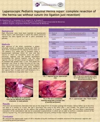
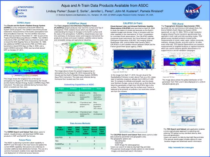
Aqua and A-Train Data Products Available from ASDC Lindsay Parker1,Susan E. Sorlie1, Jennifer L. Perez2, John M. Kusterer2, Pamela Rinsland2 (1) Science Systems and Applications, Inc., Hampton, VA, USA. (2) NASA Langley Research Center, Hampton, VA, USA. ATMOSPHERIC SCIENCE DATA CENTER CERES (Aqua) CALIPSO (A-Train) FLASHFlux (Aqua) TES (Aura) The Clouds and the Earth's Radiant Energy System (CERES) is a key component of the Earth Observing System (EOS) program. The CERES instruments provide radiometric measurements of the Earth's atmosphere from three broadband channels. The first CERES instrument (PFM) was launched on November 27, 1997 as part of the Tropical Rainfall Measuring Mission (TRMM). Two CERES instruments (FM1 and FM2) were launched into polar orbit on board the EOS flagship Terra on December 18, 1999, two additional CERES instruments (FM3 and FM4) were launched on board EOS Aqua on May 4, 2002, and a recent CERES instrument (FM5) was launched aboard NPP on October 27, 2011. The Fast Longwave And SHortwaveRadiative Fluxes (FLASHFlux) project produces near real-time surface and Top of Atmosphere (TOA) radiative fluxes which are important for understanding the impact of changes to the Earth's surface and the state of the atmosphere. FLASHFlux disseminates near real-time estimates of shortwave (solar) and longwave (terrestrial) flux products to climate and ocean modelers, satellite science teams, and renewable energy and agricultural industries. The Tropospheric Emission Spectrometer (TES) launched into sun-synchronous orbit aboard Aura, the third of NASA's Earth Observing System (EOS) spacecraft, on July 15, 2004. TES is a high-resolution imaging infrared Fourier-transform spectrometer that operates in both nadir and limb-sounding modes. TES global survey standard products include profile measurements of ozone, water vapor, carbon monoxide, methane, nitrogen dioxide, and nitric acid for 16 orbits every other day. TES Special Observations are research measurements of targeted locations or regional transects which are used to observe specific phenomena or to support local or aircraft validation campaigns. Cloud-Aerosol Lidar and Infrared Pathfinder Satellite Observations (CALIPSO) was launched on April 28, 2006 to study the impact of clouds and aerosols on the Earth's radiation budget and climate. It flies in formation with five other satellites in the international "A-Train" constellation for coincident Earth observations. The CALIPSO satellite comprises three instruments, the Cloud-Aerosol Lidar with Orthogonal Polarization (CALIOP), the Imaging Infrared Radiometer (IIR), and the Wide Field Camera (WFC). CALIPSO is a joint satellite mission between NASA and the French government space agency, CNES. The image above shows the upward longwave top of atmosphere flux for August 30, 2010 measured by the Clouds and the Earth’s Radiant Energy System (CERES) Aqua FM-3 instrument. This data was collected during Hurricane Earl, located over San Juan. Image credit: CALISPO Team In this image from April 17, 2010, the ash cloud of the Eyjafjallajökull Volcano is seen above Paris as a thin, wispy layer of particles ranging in altitude from 6,000 to 21,000 feet. To compare its altitude and breadth, see the clouds over Northern Europe, some of which are so thick that they block the penetration of light from CALIPSO's lidar to the surface. The yellow layer near the surface over France is believed to be primarily air pollution, but could also contain ash from the volcano. Image credit: TES Team This image shows the longwave flux at the top of atmosphere for August 30, 2010 measured by the Clouds and the Earth’s Radiant Energy System (CERES) Aqua FM3 instrument. This data was collected during Hurricane Earl, which is located over San Juan. The image above shows the global distribution of CO generated from TES Level 3 data displayed on a uniform latitude/longitude grid. Subsetting Capabilities at ASDC Data Access Methods • The TES Search and Subset web application enables a more sophisticated approach to selecting and ordering TES global survey standard data by date, time and geolocation. • Users can search for data by day/night flag and date • The granule results page includes options to view • browse images and download search information The CERES Search and Subset Tool allows users to subset, visually browse, and download CERES data products in HDF and NetCDF file formats. • The CALIPSO Search and Subset Tool allows users to order data subset by parameter and geographic area. • The geographic options are: • Bounding box • Orbit/Path • ESRI Shape file (demographics) • Users can search for data by day/night flag and date • The granule results page includes options to view browse • images and download search information Future Plans The ASDC is planning to provide subset capability to MOPITT and TES data in the near future and update the current MISR capability. Discussions are underway to consider additional data distribution formats. The use of a common framework enables more rapid development and deployment of enhanced access features. • http://eosweb.larc.nasa.gov