Download
1 / 16
160 likes | 169 Views
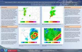
M erging R adar Q uantitative P recipitation E stimates ( QPE s ) from the H igh-resolution N EXRAD R eanalysis over C ONUS with R ain-gauge O bservations. Olivier Prat 1 , Brian Nelson 2 , Scott Stevens 1 , Elsa Nickl 1 ,

E N D
Merging Radar Quantitative Precipitation Estimates (QPEs) from the High-resolution NEXRAD Reanalysis over CONUS with Rain-gauge Observations Olivier Prat1, Brian Nelson2, Scott Stevens1, Elsa Nickl1, Dong-Jun Seo3, Beomgeun Kim3, Jian Zhang4, and Youcun Qi5 1CICS-NC/NCSU, Asheville, NC, USA | 2NOAA/NCEI/CWC, Asheville, NC, USA | 3UT Arlington, Arlington, TX, USA | 4NOAA/NSSL, Norman, OK, USA | 5CIMMS/OU, Norman, OK, USA AGU Fall Meeting 2015
Outline • Provide long-term high-temporal and spatial resolution quantitative precipitation estimates (QPEs) suitable for hydrological, meteorological and climatological applications • The National Mosaic and Multi-sensor QPE (NMQ/Q2) : • A 15 year reanalysis (CICS-NC, NCEI, NSSL) using a state of the art retrieval algorithm (NSSL) • Provides substantial improvement in quality and resolution (1-km and 5-min) • Objectives : • Bias adjustment of the radar only QPE by merging with in-situ rain gauge information • Investigate the optimal techniques for bias-adjustment • Benchmark : Inverse Distance Weighting (IDW) • Advanced : Ordinary Cokriging (OCK) • More advanced : Conditional Bias Penalized Cokriging (CBPCK)
NEXRAD Based Products Comparison • Seamless Hybrid Scan Mosaic • Stage II Radar Only • Stage IV • NMQ Radar Only • Non Standard Beam Blockage • Stage II Radar Only • Stage IV • NMQ Radar Only • RFC Boundaries • Stage IV • NMQ Radar Only
Fractional Standard Error (FSE) Seasonal Annual • Systematic bias for NMQ vs. Stage IV at the annual and seasonal scale for daily precipitation • The NMQ is Radar-Only QPE, which means there is lots of room to improve upon as compared to St IV
Radar-Only QPE Gauge Observations Merging Radar-Only QPE with Gauge Obs. GHCN (Daily) HADS (Hourly) Multisensor QPE ≈ 8800 RGs ≈ 9100 RGs • Inverse Distance Weighting (IDW) • Ordinary Cokriging (OCK) • Conditional Bias-Penalized Cokriging (CBPCK) • USCRN (5 min) • ASOS (5 min) • Optimal method for bias-adjustment of the Radar-Only QPE ?
IDW : Daily Scale : GHCN Original IDW Adjustment Original IDW Adjustment 08/13/2011 03/10/2011
IDW : Hourly Scale : HADS Original IDW Adjustment Original IDW Adjustment 08/13/2011 08Z 10Z 12Z 08/13/2011
RADAR ONLY IDW ADJUSTED IDW ADJUSTED (RAW>0) IDW Bias Adjustment (Hourly)
RADAR ONLY IDW ADJUSTED Daily Bias Adjustment of Radar-Only QPE IDW ADJUSTED (RAW>0) Beam Blockage • IDW adjusted precipitation patterns are considerably improved over the Western US • Condition on IDW (Rad. Only>0) reduces precipitation totals when radar coverage is limited (Western US)
IDW : Annual Accumulation IDW IDW RAW>0 • Bias adjustment can’t be applied consistently across CONUS
Hourly HADS Gauge QC/QA : 2011 • Gauge data from the HADS feed • Basic QC for large errors and stuck gauges • Gauge data from the reprocessed HADS • Additional levels of QC • No Precipitation Mask • Precipitation Mask (Radar Only >0) HADS vs. GHCN • RG QA/QC is an important part of the process
Inter-annual Variability (2002-2011) IDW HOURLY RAW STAGE IV IDW DAILY 2007 2008 2009 2010 2011
Inter-annual Variability (2002-2011) IDW DLY – IDW HRLY IDW DLY – RAW IDW HRLY – RAW 2007 2008 2009 2010 2011
Optimal Merging of Radar QPE and Gauges • Basic Inverse Distance Weighting (IDW) values to unknown points are calculated with a weighted average of known point values creates artificial rain and bull eyes when network is sparce • Advanced Ordinary Cokriging (OCK) best linear unbiased estimator by minimizing unconditional error variance providing unbiased means under/overestimate large/light precipitation • More Advanced Conditional Bias Penalized Cokriging (CBPCK) (Seo 2013) minimizes conditional bias in addition to error variance 199 RGs USCRN ASOS HADS • North and Central Texas • USCRN • ASOS • HADS
Gauge Radar-Only Advanced Bias Adjustment OCK Adjusted CBPK Adjusted March 2008 Nov. 2009 Kim et al. 2015
Conclusions • This is a UNIQUE long-term CONUS wide reanalysis at HIGH RESOLUTION • STATUS : • Full period of record (10 years) of Radar-Only QPE at 5-min scale (2001-2011) • Full period of record for Bias-Adjusted QPE at daily scale (Beta version) • Full period of record for Bias-Adjusted NMQ at hourly scale (Beta version) • In PROGRESS : • Homogenize rain gauge data by merging the different networks (CRN, HADS, GHCN) • Implement CONUS wide mean field Bias-Adjustment (global, seasonal, monthly, and/or as a function of climatic zones or river basin) • Implement CONUS wide advanced Bias-Adjustment methods (OCK, CBPCK) • Investigate satellite QPE for including in a multi-sensor product in particular over blocked areas (West) • Generate a climate quality dataset 10 Years 1 Year ? 1 Week Advanced IDW