Download
1 / 106
1.06k likes | 1.07k Views
Divergent Plates Transform Plates NOAA: Plate Tectonics NOAA: Subduction Main types of plate boundaries [This Dynamic Earth, USGS]. Drifting Continents. Drifting Continents. Earth’s surface appears to remain relatively unchanged during the course of an average human lifetime.

E N D
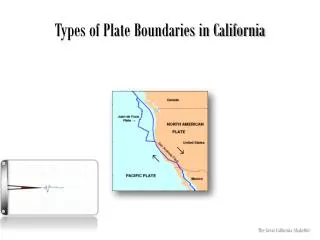
Divergent Plates • Transform Plates • NOAA: Plate Tectonics • NOAA: Subduction • Main types of plate boundaries [This Dynamic Earth, USGS]
Drifting Continents Drifting Continents • Earth’s surface appears to remain relatively unchanged during the course of an average human lifetime. • On the geologic time scale, Earth’s surface is changing at rates almost too great to imagine.
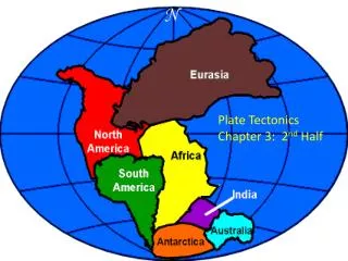
Drifting Continents Early Observations • In the late 1500s, Abraham Ortelius, a Dutch mapmaker, noticed the apparent fit of continents on either side of the Atlantic Ocean. • In the late 1800s, Eduard Suess, an Austrian geologist, hypothesized that the present southern continents had once been joined as a single landmass that he named Gondwanaland. • The first time that the idea of moving continents was proposed as a serious scientific hypothesis was in 1912 by a German scientist named Alfred Wegener.
Drifting Continents Continental Drift • Wegener’s hypothesis, continental drift, proposed that Earth’s continents had once been joined as a single landmass. • Wegener proposed that Pangaeabegan to break apart about 200 million years ago and that the continents had continued to slowly move to their present positions. • Pangaea, a Greek word that means “all the earth,” refers to the combined landmass.
Drifting Continents Continental Drift
Continental Drift Matching coastlines
Drifting Continents Continental Drift Evidence from Rock Formations • Wegener reasoned that large geologic structures, such as mountain ranges, would have fractured as the continents separated. • Using this reasoning, Wegener hypothesized that there should be areas of similar rock types on opposite sides of the Atlantic Ocean. • That similar groups of rocks were observed in the United States, Greenland, and Europe supported Wegener’s idea.
Drifting Continents Evidence from Rock Formations- Appalachian Mountains
Drifting Continents Continental Drift Evidence from Fossils • Similar fossils of several different animals and plants that once lived on land had been found on widely separated continents. • The ages of different fossils predated Wegener’s time frame for the breakup of Pangaea. • Fossils of Glossopteris, a seed fern that resembled low shrubs, have been found on many continents, indicating that the areas had a single climate that was close to the equator.
Drifting Continents Continental Drift- Evidence from Fossils
Drifting Continents Continental Drift Ancient Climatic Evidence • Various sedimentary rocks offer evidence of vast climatic changes on some continents. • Coal deposits in Antarctica suggested that it must have been closer to the equator. • Glacial deposits found in Africa, India, Australia, and South America suggested that these areas had once been covered by thick ice caps. • Wegener proposed that they once were located near the south pole before Pangaea began to fracture.
Drifting Continents Continental Drift Ancient Climatic Evidence
Observe an animation of the breakup of Pangaea. • Pangaea animation
Drifting Continents A Rejected Hypothesis • In the early 1900s, most scientists rejected Wegener’s hypothesis of continental drift. • Two unanswered questions: • What forces could move continents? • How continents could move without shattering? • It wasn’t until the 1960’s that scientists began to widely accept his theory. This was due to the inventions of SONAR and echo-sounding.
Drifting Continents Section Assessment 1. How did Pangaea differ from the present layout of the continents? During Pangaea, the continents were joined and essentially located in one hemisphere from the north to the south poles. Presently, the continents have separated and are distributed in both the eastern and western hemisphere, with the majority of landmass in the northern hemisphere.
Drifting Continents Section Assessment 3. Identify whether the following statements are true or false. ______ Similar rock types are located in South America and Africa. ______ Gondwanaland and Pangaea essentially refer to the same thing. ______ Coal located in India and Africa suggest that they were once located in warmer climates. ______ Geologic evidence suggests that North America, Greenland, and Europe were once connected. true true false true
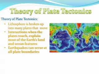
Theory of Plate Tectonics Plate Map
Theory of Plate Tectonics Theory of Plate Tectonics • The theory of plate tectonics states that Earth’s crust and rigid upper mantle are broken into enormous moving slabs called plates. • There are seven major plates. (North America, South America, Eurasian, Indo-Australian, Antarctic, Pacific and Africa. • The largest is the Pacific. • There are several smaller plates, including the Caribbean, Nazca, Juan de Fuca, Caroline, Scotia, Cocos, and the Arabian plate.
Theory of Plate Tectonics • Tectonic plates move in different directions and at different rates over Earth’s surface. • Most plates move the speed of growing fingernails. • They move 2 to 3cm per year, up to 8 to 9cm per year. • This averages out to about 5cm per year. • The fastest rate is 11.7cm per year.
Theory of Plate Tectonics Plate Boundaries • Tectonic plates interact at places called plate boundaries. • At some plate boundaries: • Plates come together, or converge • Plates move away from one another, or diverge • Plates move horizontally past one another, at a transform boundary
Theory of Plate Tectonics Plate Boundaries Divergent Boundaries • Divergent boundaries are places where two tectonic plates move apart. • Most divergent boundaries are found on the ocean floor where they are making new ocean crust.
Divergent Boundary • The Atlantic Ocean is growing at a rate of 2-3 cm per year.
Rift Valley • A rift valley, which is a narrow depression, is created when a divergent boundary forms on a continent.
Theory of Plate Tectonics Plate Boundaries Convergent Boundaries • Convergent boundaries are places where two tectonic plates are moving toward each other. • There are three types of convergent boundaries: 1. Oceanic crust converging with oceanic crust 2. Oceanic crust converging with continental crust 3. Continental crust converging and colliding with continental crust.
Theory of Plate Tectonics Plate Boundaries Convergent Boundaries
Theory of Plate Tectonics Plate Boundaries Convergent Boundaries • Subduction occurs when one of the two converging plates descends beneath the other. • A subduction zone forms when one oceanic plate, which has become denser as a result of cooling, descends below another plate creating a deep-sea trench. • The subducted plate descends into the mantle and melts. • Some of the magma forms new oceanic crust at the ridge or is forced back to the surface, forming an arc of volcanic islands that parallel the trench.
Oceanic-oceanic • The older, denser plate subducts • This creates an oceanic trench and a chain of volcanic islands. • Two examples are the Mariana Trench and Islands and the Aleutian Trench and Islands.
Oceanic-continental • When an oceanic plate converges with a continental plate, the denser oceanic plate is subducted. • This creates an oceanic trench and a chain of volcanoes along the edge of the continental crust. • An example is the Peru-Chile Trench and the Andes Mountains where the Nazca plate is subducting under the South American plate.
Convergent Boundaries • Oceanic- continental animation • Observe an animation of volcanism at a subduction zone.
Theory of Plate Tectonics Plate Boundaries Continental-continental • Two continental plates collide, the colliding edges of the continents are crumpled and uplifted to form a mountain range.
Where India is crashing into India is an example. The Himalayan mountains are formed here, the highest in the world.