Download
1 / 27
270 likes | 274 Views
This presentation discusses the use of remote sensing and RTK GPS technology to develop roadway centerlines and extract roadway features. It covers the process of collecting aerial photography data and linking it to mileposts, as well as the development of a 3D database for transportation data management.

E N D
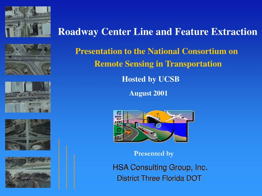
Roadway Center Line and Feature Extraction Presentation to the National Consortium on Remote Sensing in Transportation Hosted by UCSB August 2001 Presented by HSA Consulting Group, Inc. District Three Florida DOT
Background • Genesis of FDOT District Three Project • Use of RTK GPS to Develop Roadway Centerline • Initial Vision • Use Remote Sensing(Aerial Photography) to Collect RCI Data and Link X,Y,Z to Mileposts • Development of Stereoscopic Data Base • Expanded Vision • Use 3D Database for Transportation Data Management for Multiple Units in FDOT
Spatial Data Process for Center Line and Roadway Feature Extraction Processed Digital Stereo Imagery Stereoscopic Data Collection Tool Raw Digital Aerial Data Center Line and RCI Feature Extraction Spatial Data Production Aerial Production
Spatial Data Process for Center Line and Roadway Feature Extraction Processed Digital Stereo Imagery On & Off System Imagery/ RCI Database Raw Digital Aerial Data Inventory Line And RCI Feature Extraction Spatial Data production Aerial Production
Spatial Data Process for Inventory Line and Roadway Feature Extraction Processed Digital Stereo Imagery On & Off System Imagery/ RCI Database Raw Digital Aerial Data Inventory Line And RCI Feature Extraction Spatial Data production Aerial Production
Spatial Data Process for Center Line and Roadway Feature Extraction Processed Digital Stereo Imagery On & Off System Imagery/ RCI Database Raw Digital Aerial Data Inventory Line And RCI Feature Extraction Spatial Data production Aerial Production
Spatial Data Process for Center Line and Roadway Feature Extraction Processed Digital Stereo Imagery Stereoscopic Data Collection Tool Raw Digital Aerial Data Center Line and RCI Feature Extraction Spatial Data Production Aerial Production
Spatial Data Process for Center Line and Roadway Feature Extraction Image is Not Yet Controlled or Geo-coded. Raw Digital Aerial Data
Spatial Data Process for Center Line and Roadway Feature Extraction Processed Digital Stereo Imagery Stereoscopic Data Collection Tool Raw Digital Aerial Data Center Line and RCI Feature Extraction Spatial Data Production Aerial Production
Spatial Data Process for Center Line and Roadway Feature Extraction Processed Digital Stereo Imagery On & Off System Imagery/ RCI Database Spatial Data Production Ø Apply Ground Control Ø Apply Ground Control § Receive ground control information from the flight crew § Receive ground control information from the flight crew Inventory Line And RCI Feature Extraction Spatial Data production (camera position data, flight height, focal length, camera (camera position data, flight height, focal length, camera Spatial Data Production calibration report, etc.) calibration report, etc.) § Receive ground control information from the GPS crew § Receive ground control information from the GPS crew Ø Apply Aerotriangulation (AT) Solution Ø Apply Aerotriangulation (AT) Solution § Determine the relationship between the camera and the § Determine the relationship between the camera and the ground ground § Perform (AT) solution to achieve highly accurate resection § Perform (AT) solution to achieve highly accurate resection solution solution
Spatial Data Process for Center Line and Roadway Feature Extraction Processed Digital Stereo Imagery On & Off System Imagery/ RCI Database Inventory Line And RCI Feature Extraction Spatial Data production Spatial Data Production
FGDC-STD-007.3-1998 Geospatial Positioning Accuracy StandardsPart 3: National Standard for Spatial Data Accuracy Subcommittee for Base Cartographic Data Federal Geographic Data Committee Use the “compiled to meet” statement below when the above guidelines for testing by an independent source of higher accuracy cannot be followed and an alternative means is used to evaluate accuracy. Report accuracy at the 95% confidence level for data produced according to procedures that have been demonstrated to produce data with particular horizontal and vertical accuracy values as: Compiled to meet ____ (meters, feet) horizontal accuracy at 95% confidence level ____ (meters, feet) vertical accuracy at 95% confidence level Report accuracy for data tested for horizontal accuracy and produced according to procedures that have been demonstrated to comply with a particular vertical accuracy value as: Tested ____ (meters, feet) horizontal accuracy at 95% confidence level Compiled to meet ____ (meters, feet) vertical accuracy at 95% confidence level For digital geospatial data, report the accuracy value in digital geospatial metadata (Federal Geographic Data Committee, 1998, Section 2), as appropriate to dataset spatial characteristics: (Data_Quality_Information/Positional_Accuracy/Horizontal_Positional_Accuracy/Horizontal_Positional_Accuracy_Assessment/Horizontal_Positional_Accuracy_Value) and/or (Data_Quality_Information/Positional_Accuracy/Vertical_Positional_Accuracy/Vertical_Positional_Accuracy_Assessment/Vertical_Positional_Accuracy_Value) Enter the text “National Standard for Spatial Data Accuracy” for these metadata elements (Federal Geographic Data Committee, 1998, Section 2), as appropriate to dataset spatial characteristics: (Data_Quality_Information/Positional_Accuracy/Horizontal_Positional_Accuracy/Horizontal_Positional_Accuracy_Assessment/Horizontal_Positional_Accuracy_Explanation) and/or (Data_Quality_Information/Positional_Accuracy/Vertical_Positional_Accuracy/Vertical_Positional_Accuracy_Assessment/Vertical_Positional_Accuracy_Explanation) (Data_Quality_Information/Positional_Accuracy/Horizontal_Positional_Accuracy/Horizontal_Positional_Accuracy_Report) and/or (Data_Quality_Information/Positional_Accuracy/Vertical_Positional_Accuracy/Vertical_Positional_Accuracy_Report)
Spatial Data Process for Center Line and Roadway Feature Extraction Processed Digital Stereo Imagery Stereoscopic Data Collection Tool Raw Digital Aerial Data Center Line and RCI Feature Extraction Spatial Data Production Aerial Production
Spatial Data Process for Center Line and Roadway Feature Extraction Each pixel is geo-coded to an accuracy level of 8 centimeters x,y,z. Processed Digital Stereo Imagery
Spatial Data Process for Center Line and Roadway Feature Extraction Processed Digital Stereo Imagery Stereoscopic Data Collection Tool Raw Digital Aerial Data Center Line and RCI Feature Extraction Spatial Data production Aerial Production
Spatial Data Process for Center Line and Roadway Feature Extraction Develop 3D Center Line Linked to Mileposts Ø Using Stereoscopic Desktop Tool, Navigate Within Imagery to Center Line and RCI Feature Extraction Coordinates Along Roadway Centerline Ø Store X,Y,Z Data Points On the Center Line, Automatically Linking to Linear Milepost References Ø Calculate Total Length of Roadway Sections, by Capturing Changes in Horizontal and Vertical Curvature Ø Extract RCI Features Along the Center Line, Storing the Spatial and Linear Position in an Access Data Base
Spatial Data Process for Center Line and Roadway Feature Extraction Center Line and RCI Feature Extraction
Spatial Data Process for Center Line and Roadway Feature Extraction Center Line and RCI Feature Extraction
Spatial Data Process for Center Line and Roadway Feature Extraction Center Line and RCI Feature Extraction
Digital Extraction of RCI Data Traditional DMI Method Non-Traditional Digital Method NITESTAR Straight Line Diagram of Roadway
Spatial Data Process for Center Line and Roadway Feature Extraction PC-Based Desktop Stereoscopic Tool Stereoscopic Data Collection Tool
Centerline and Feature Extraction3D Demonstration TransDat - TransView • Using Stereoscopic Desktop Tool, Navigate Within Imagery to Coordinates Along Roadway Centerline • Store X,Y,Z Data Points On the Center Line, Automatically Linking to Linear Milepost References • Calculate Total Length of Roadway Sections by Capturing Changes in Horizontal and Vertical Curvature • Extract RCI Features Along the Center Line, Storing the Spatial and Linear Position in an Access Data Base
R3D Data Production Costs • Aerial Photography - $ 53 per C/L Mile • Scanning/Film Processing - $ 111 per C/L Mile • Ground Control - $ 511 per C/L Mile • AT - $ 250 per C/L Mile • Create Roadway 3D Dataset, And Extract Center Line - $ 225 per C/L Mile • Roadway Feature Extraction - $ 65 per C/L Mile • Total Cost Per Mile: $1215 per C/L Mile
CO Systems Planning Project Development Design Traffic Operations Construction & Maintenance Safety Location & Right-of-Way Surveying & Mapping TranStat Leveraging Data Acquisition and Use Planning Project Development Design Traffic Operations Construction & Maintenance Safety Location & Right-of-Way Surveying & Mapping TranStat
Summary • The Initial Vision of FDOT District Three was use of High Resolution Aerial Photography to Generate Spatial Data for Developing a Highly Accurate Roadway Centerline. • The HSA Consulting Team Developed a Stereoscopic Feature Extraction and Measurement Tool Which Allowed Mileposts to be Linked to X,Y,Z Coordinates Along the Roadway Centerline. • Successfully Linking the Department’s Linear Referencing System to Three-Dimensional Coordinates Resulted in an Expanded Vision: 1.Linking the Stereoscopic Imagery to Other 3D Databases 2. Linking Aerial Data with Other Perspectives Such as Video Logs 3. Expanding the Functionality of the Stereoscopic Data Collection Tool to Serve as an Integrated Transportation Data System