Download
1 / 34
340 likes | 523 Views
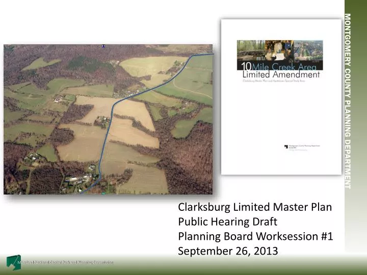
Clarksburg Limited Master Plan Public Hearing Draft Planning Board Worksession #1 September 26, 2013. Schedule. 7/22- Planning Board Tour 7/22 Community Meeting to review Staff Draft Recommendations 7/25 – Planning Board review of Staff Draft Plan 9/10 – Public Hearing

E N D
Clarksburg Limited Master Plan Public Hearing Draft Planning Board Worksession #1 September 26, 2013
Schedule • 7/22- Planning Board Tour • 7/22 Community Meeting to review Staff Draft Recommendations • 7/25 – Planning Board review of Staff Draft Plan • 9/10 – Public Hearing • 9/26 – Planning Board Worksession #1 • 10/10 – Planning Board Worksession #2 • 10/24 Transmit Planning Board draft to County Executive and County Council • December –Council Public Hearing • December-February – County Council Worksessions, Council approval • February-April – Commission Adoption, Sectional Map amendment
Topics • What we believe • Overview of the key policy questions • Overview of the recommended land use/zoning concept • Consultant presentation • Potential changes to the Plan • Direction from the Board
Fundamental Question for Board Based on the fact that Ten Mile Creek is as a very high quality reference stream in Montgomery County, and provided that staff sought guidance from multiple County, State and Federal agencies, including the EPA, is this a sensitive enough watershed to warrant protection through the application of impervious caps in conjunction with other measures, including ESD?
We Believe….. • A “planning level” analysis was the right approach to evaluate watershed-wide impacts and that the modeling methods are complete and the findings are sound; • Water quality, watershed ecology and stream biology all play important roles in determining watershed health; • Increased urbanization results in degrading all aspects of watershed health; • Environmental Site Design cannot by itself maintain watershed ecology or biology in sensitive, high quality streams; • Prudent planning dictates a combination of ESD and resource protection; • The Limited Amendment reflects prudent environmental, land use and zoning recommendations for this sensitive resource.
Amending the Plan • General Plan • Becomes a fourth corridor city • 1968 Clarksburg Plan • Scaled down to Corridor Town • 1994 Clarksburg Plan • Reduces scale and balances environmental protection with transit supportable development • Town Center partly in Ten Mile Creek headwaters • Housing in Ten Mile Creek • Stages development Clarksburg’s Evolution
Amending the Plan 1994 Plan Staging • Stage 4 triggers have been met • Provided Council review at that time • Water quality evaluations complete, but inconclusive • Council has opted to prepare master plan amendment • May consider other land use actions
Amending the Plan Policy Approach--refining earlier objectives • Geography sets the stage—Town Center on high ground, watersheds separated by roads along ridgelines, influencing land use goals and objectives • Acknowledges evolving environmental standards and lessons from other plans in sensitive Upper Paint Branch and Upper Rock Creek watersheds • Reflects consultants’ conclusions that innovative techniques and preservation of undeveloped open space should combine to maximize resource protection
Amending the Plan Policy Approach--refining earlier objectives • East of I-270 • recognizes balance struck in 94 Plan between Town Center and resource protection • imperviousness reduced while retaining mixed uses to reinforce the Town Center • West of I-270 • continues housing uses and accommodate TDRs • recognizes that protecting sensitive resources requires reducing impacts on watershed’s highest quality tributaries • requires environmental site design and reduced imperviousness
Public Hearing Draft Concept • Emphasize Environmental Protection • Preserve natural resources • Maximize undeveloped open space • Minimize imperviousness • Retain housing • Emphasize Community Building • Complement Town Center • Strengthen Historic District • Balance Mixed Use • Improve Transportation
Protect Ten Mile Creek and Reservoir Above All • County Council indicated to consider all goals • Plan balances Ten Mile Creek protection with development in support of the 1994 Plan’s transit focus by concentrating growth in the Town Center District 1
Little Seneca Reservoir • Part of a reservoir system that adds water to the Potomac during droughts – not a direct drinking source • Reservoir built with safeguards against sedimentation • Important to protect water quality, but protecting the Creek will protect the quality of the lake • Potential Impacts of Climate Change • More extreme storms and droughts • Impact on groundwater and total stream input to lake similar under different land use proposals 1
Status of Ten Mile Creek: Status and Potential Risks • One of the best quality streams in the County (Good to Excellent) • One of three remaining principal reference streams in Western Montgomery County • - The reference station is just downstream of LSTM 110 and 111, which are proposed in the 1994 Plan for significant amounts of development. • An unusually sensitive watershed with thin rocky soils • Has declined in biological health since 1995 • Small watershed changes can have significant biological effects in TMC 1
Confidence in Approach • Use a science-based approach • Vetting of approach • Technical Overview • EPA • USGS • Continuing Advice from: • Maryland Department of the Environment • Maryland Department of Natural Resources • Montgomery County Department of Environmental Protection • Montgomery County Department of Permitting Services • Best Data available at the watershed level
Guidance from the State of Maryland • Considered MDE, DNR, EPA and USGS Guidance on the Benefits and Limitations of ESD • Considered State Bay Critical Areas Protection Requirements • combines limiting the footprint of development and impervious cover, with the use of ESD • SWM and ESD BMPs are not granted credits towards the imperviousness limits
Biological Condition Gradient Results for TMC Natural structural, functional, and taxonomic integrity is preserved 1 Minimal changes in structure and function 2 Evident (e.g. measurable) changes in structure, minimal changes in function King Spring (invert) 3 Above Old Baltimore Rd (invert/fish) Moderate changes in structure & evident changes in function 4 Biological Condition Below Old Baltimore Rd (invert/fish) 5 Major changes in structure & moderate changes in function 6 Severe changes in structure & function Increasing Level of Stress
Science-Based Approach • No single model or tool can measure stream health or degradation • Combination of approaches used to formulate recommendations • Documentation of existing watershed conditions • Review of extensive biological monitoring data • Field observations • Scientific literature review • Findings from nearby watersheds • Hydrologic modeling • Natural resources spatial analysis • Pollutant load analysis • Biological Condition Gradient Results for Ten Mile Creek • Planning level study • Consistent level of detail and assumptions across the study area used to evaluate both existing conditions and different master planning scenarios • All scenarios studied relative to existing conditions 1
Hydrologic Modeling Analysis • Many models available • Used XP-SWMM (originally developed by U.S. EPA) • Provides one tool to predict overall impacts of land use decisions • May be used to test a variety of land use alternatives • Relies on generalized stormwater management assumptions to represent range of site conditions and stormwater management effectiveness • Strength of the modeling approach is the emphasis on the predictive capability of comparable results under various development scenarios • Incorporates a level of conservatism to account for generalizations, variations and unknowns 1
ESD – Environmental Site Design • Model represented standard microbioretention design • ESD model parameters developed in consultation with Planning, DEP and DPS • Clarification to H&H report on how ESD modeled Montgomery County’s Micro-Bioretention Design Standard • Ponding above media - 9” • Infiltration to planting media • Overflow to outlet • Underdrains with overflow to surface waters 1
Analysis Considered Many Important Factors • ESD practice limits • Increased annual runoff volume • Construction phase impacts • Collective modifications to vegetation, soils & hydrology • Changes in infiltration & evapotranspiration 1994 Master Plan Scenario Forest Interior NOT Included 1
Environmental Analysis Conclusions East of I270 - highest levels of existing impervious cover and fair stream conditions West of I270 - dominated by small, high quality tributaries, forest cover and rural land uses Increases in stormwater runoff expected despite application of ESD practices ESD does represent the state of the practice for site and subdivision development Rigorous and comprehensive implementation across or within watersheds has not occurred nor been monitored
Rationale for Resource Protection and Community-Building Recommendations • In sensitive watersheds, Council has taken this same approach: Concentrate growth where necessary in a part of the watershed that is consistent with community-building goals • Upper Rock Creek • Burtonsville • Damascus • Olney • The 8% cap is considered a standard for protection - allows some buffer for increasing imperviousness over time and the degradation of stormwater BMP’s • All properties are being cut back proportionately from expected imperviousness levels 1
Options • No Build 4% imperviousness • Ag Reserve on West Side including County property • Parkland on East side • No Bypass • Keep Fire Station and Historic District development • Retrofit existing untreated areas at public cost • Requires public extension of sewer to HD
Options • Low Build 6% imperviousness • All developable properties = RC • No Bypass • Keep Fire Station and Historic District development • Requires public extension of sewer to HD
Options • Low Build with Focus on Community Building 6% imperviousness • Egan = RC • Miles/Coppola = CR • Keep Fire Station and Historic District development • Pulte = RDT • County property = parkland
Options • Public Hearing Draft • Egan = R200 • Miles/Coppola = CR • Build Bypass • Keep Fire Station and Historic District development • Developer provides sewer to Historic District • Pulte = RNC 8% cap • County property = 8% cap
Options • Property Owner requests • Egan = R200 • Miles/Coppola = CR 35% cap • Build Bypass • Keep Fire Station and Historic District development • Developer provides sewer to Historic District • Pulte = RE-1/TDR 15% cap • County property = 15% cap
Options Summary LOWER RISK HIGHER RISK
Staff Draft Master PlanRecommendations Land Use and Zoning • Zoning recommendations respect 94 Plan density transition from Town Center to Ag Reserve • CR zones allow market conditions to help guide development decisions • Floating zone options allow focus on residential uses while retaining some commercial potential