Download

1 / 12
120 likes | 208 Views
Learn to differentiate between discrete and continuous data, such as height, population, and unemployment rate. Explore signature techniques for various objects in geographic information systems.

E N D
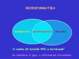
GEO – INFORMATION II Darstellung diskreter Phänomene
Unterscheidung Kontinuierlichz.B. Höhe, Bevölkerung,Arbeitslosenquote Diskretz.B. Straßentypen,Landnutzung GeoInformation II - WS 2000 / 2001 - 23.Oktober 2000
Signaturierung diskreter Objekte • Möglichkeiten: • Single Symbol: Alle Objekte eines Layer gleich • Unique Values: Abhängig von Attributwert • Unique Values, many Fields: Abhängig von Kombination mehrerer Attributwerte GeoInformation II - WS 2000 / 2001 - 23.Oktober 2000
Beispiel Flächenhafte Signaturen Datei: D:\GIS-Data\Esri\ArcInfoDesktop \SampleMaps\Data\ClarkCo\landuse.shp GeoInformation II - WS 2000 / 2001 - 23.Oktober 2000
1. Aufgabe Kopieren Sie die Datei D:\GIS-Data\Esri\ArcInfoDesktop\SampleMaps\ Data\ClarkCo\landuse.shp in ein lokales Verzeichnis, öffnen Sie diese in ArcMap und signaturieren Sie die Flächenobjekte in anschaulicher Weise. Verwenden Sie das Attribut DESC. Die Legende sollte möglichst übersichtlich sein: gruppieren Sie, wo es sinnvoll erscheint. GeoInformation II - WS 2000 / 2001 - 23.Oktober 2000
Beispiel Punkthafte Signaturen Datei: D:\GIS-Data\Esri\ArcInfoDesktop \SampleMaps\Data\JoshuaTreeNP\campgr.shp GeoInformation II - WS 2000 / 2001 - 23.Oktober 2000
Beispiel Linienhafte Signaturen Datei: V:\GIS-Proseminar\strassen.shp GeoInformation II - WS 2000 / 2001 - 23.Oktober 2000
Amtliche Signaturen: TK 25 GeoInformation II - WS 2000 / 2001 - 23.Oktober 2000
Amtliche Signaturen: TK 25 GeoInformation II - WS 2000 / 2001 - 23.Oktober 2000
Kommerzielle Straßenkarte USA GeoInformation II - WS 2000 / 2001 - 23.Oktober 2000
Bundesautobahn Bundesstraße (mehrspurig) Bundesstraße (einspurig) Bundesautobahn im Bau Bundesstraße im Bau 2. Aufgabe Öffnen Sie die Datei V:\GIS-Proseminar\strassen.shp und signaturieren Sie die Straßen nach der Legende amerikanischer Straßenkarten:
Vielen Dank für Ihre Aufmerksamkeit und Viel Spaß mit ArcInfo