Download
1 / 71
730 likes | 747 Views
The U.S. Continuously Operating Reference Station (CORS) System. Richard Snay NOAA’s National Geodetic Survey Corbin, Virginia June 2008. NOAA’s National Geodetic Survey. Everyone is able to know where they are and. where other things are anytime, anyplace!.

E N D
The U.S. Continuously Operating Reference Station (CORS) System Richard Snay NOAA’s National Geodetic Survey Corbin, Virginia June 2008
NOAA’s National Geodetic Survey Everyone is able to know where they are and where other things are anytime, anyplace!
The Global Positioning System (GPS) Unaugmented GPS enables positioning with accuracies ranging from 1 to 10 meters.
The CORS network enables differential GPS positioning with accuracies from 1 to 10 centimeters, or better. Continuously Operating Reference Stations (CORS)
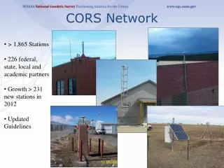
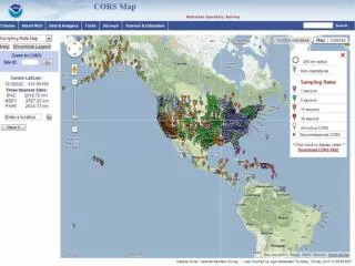
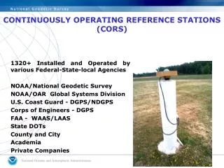
CORS Information • CORS network contains over 1,300 stations as of June 2008. • Growing at rate of about 200 stations per year. • Each station collects GPS signals, and NOAA makes these data freely available to the public via the Internet for post-processing applications. • More than 200 organizations participate in the CORS program by sponsoring and operating one or more stations.
Access to CORS Data In Silver Spring, Maryland (CORS-East) • Anonymous File Transfer Protocol (FTP) ftp://cors.ngs.noaa.gov • UFCORS - User Friendly CORS http://www.ngs.noaa.gov/UFCORS In Boulder Colorado (CORS-West) • Parallel and independent data collection and on-line storage at NOAA’s National Geophysical Data Center Anonymous FTP ftp://wwwest.ngs.noaa.gov
CORS Supports Precise Positioning A A A A A Before CORS: Accurate differential GPS positioning with multi-person field crew. After CORS: Accurate differential GPS positioning with one-person field crew.
Online Positioning UserService (OPUS) ● Collect at least 15 minutes of dual-frequency GPS data • Submit data to www.ngs.noaa.gov/OPUS/ • Data are processed automatically using NOAA • computers & software • Corresponding positional coordinates computed • with respect to 3 suitable CORS or IGS sites • Computed coordinates returned via email • (usually in minutes)
CORS enables sub-meter differential positioning with less than a minute of GPS data
CORS Enables Users to Determine the Travel Path of a Moving Platform
Aircraft Positioning with CORS 3D RMS error = 15 cm + 0.6 ppm aaaaaaaaaaaaaaaaaaaaaaaaaaaaaaaaaaaaaaaaaaaaaaaaaaa aaaaaaaaaaaaaaaaaaaaaaaaaaaaaaaaaaaaaaaaaaaaaaaaaaaa
CORS for MonitoringHorizontal Crustal Motion Horizontal velocities in the western U.S. relative to the North American Datum of 1983 as derived from geodetic observations.
CORS for Monitoring Vertical Crustal Motion Vertical velocities associated with Glacial Isostatic Adjustment
Tide Gauges Located Near a CORS Whose Vertical Crustal Velocity Has Been Accurately Determined CORS-calibrated tide gauge data indicate that the rate of sea level rise around North America was 1.8 +/- 0.2 mm/yr during the 1900-1999 time interval
CORS for Monitoring Precipitable Water Vapor NOAA’s Earth Systems Research Laboratory uses CORS data to produce nowcasts of precipitable water vapor, once every 30 minutes. Transitioning to operational status starting in 2010. NOAA will seek to install “robust” CORS on Caribbean islands and on oil platforms in the Gulf of Mexico to better anticipate the effect of an active hurricane or tropical storm.
CORS for Monitoring Space Weather NOAA’s Space Weather Prediction Center uses CORS data to map the distribution of free electrons in the ionosphere, once every 15 minutes.
Just Around the Corner Starting later in 2008, the CORS system will: • Provide GPS L2C data • Provide GLONASS data • Broadcast GNSS data via the Internet in real-time (on an experimental basis). (For selected sites only.) Red dots identify locations of CORS sites that collect both GPS and GLONASS data.
CORS ADVANTAGES OVERPASSIVE REFERENCE STATIONS • 3-dimensional (Lat., Long., & Ellipsoid Ht. or X, Y, & Z) • Eliminates control points reconnaissance (time and money). • Eliminates needing people and equipment at a control points. • Direct tie to National Spatial Reference System (NSRS). • CORS positions and velocities are available in both NAD 83 and ITRF coordinate systems. • CORS positions are of the highest accuracy. • CORS positions are continuously monitored and will be updated if the site moves.
Common Question • CORS GPS hardware differs from our GPS hardware. Do we have to use only CORS with the same hardware?
GPS Data: The Receiver INdependent EXchange (RINEX) Format • Data file spans • hourly, daily, customized (UFCORS) • Data collection rates • 1sec, 5sec, 10sec, 15sec, and 30sec • Data file life-time • hourly: 2 days + today • daily: permanently • Data are decimated to a 30-second rate after 30 days
Common Question • The closest CORS to our project area is 50 miles away. How can we use CORS at this distance?
TWO TESTS FOR POSITIONING PRECISION • Dual Frequency Carrier Phase Data • Single Frequency Code Data
TEST DESIGN:DUAL FREQUENCY CARRIER PHASE DATA • Dual Frequency Geodetic Receivers • Post-Processed with a Precise Orbits • Pairs of CORS sites forming 11 Baselines • Baseline lengths ranging from 26 to 300 km • Various Observation Session Duration • (1, 2, 4, 6, 8, 12, and 24 hours)
Positioning Error vs. Duration of the Observing Session Dual-frequency GPS carrier-phase observations
Vertical Precision Using Dual-Frequency GPS Carrier Phase Observations 95% Confidence Level
TEST DESIGN:SINGLE-FREQUENCY CODE DATA • Positioned 12 points relative to each of seven CORS sites • Baseline lengths of 18, 23, 132, 165, 170, 253, and 292 kilometers • Observed 1-minute sessions at a 5-second record rate (interpolated CORS data from 30 to 5 seconds) • Repeated experiment 4 times over a 2-day period
Positioning Accuracy with Code Data Observation Time = 1 minute red = east-west blue = north-south RMS error = 25 cm + 2 ppm
COMMENTS • Sub-Meter precision is possible with baseline lengths up to 300 kilometers • This precision is possible using interpolated CORS data • Most CORS data is available within 1-hour of the survey
SURVEYING METHODS Kinematic GPS Static Positioning (carrier phase) Static Positioning (code)
ACCESSING CORS DATA & METADATA • Web address = http://www.ngs.noaa.gov/CORS/ • Metadata = data about data • CORSAGE = CORS Amiable Geographic Environment
METADATA FOR A CORS SITE • Coordinates (positions & velocities) • Data availability profiles (charts showing times for which data has been collected) • Data sheets (descriptive information) • Log files (descriptive information) • Site photos • Time series of positional coordinates • Google Maps
CORS POSITION & VELOCITY (NAD 83) BILLINGS 1 (BIL1), MONTANA Retrieved from NGS DataBase on 01/10/01 at 09:45:16. ____________________________________________________________________________ | | | NAD_83 POSITION (EPOCH 1997.0) | | Transformed from ITRF97 (epoch 1997.0) position in Sep. 2000. | | X = -1372156.022 m latitude = 45 58 16.23742 N | | Y = -4223946.947 m longitude = 107 59 47.29949 W | | Z = 4563650.156 m ellipsoid height = 874.381 m | | | | NAD_83 VELOCITY | | Transformed from ITRF97 velocity in Sep. 2000. | | VX = 0.0000 m/yr northward = 0.0000 m/yr | | VY = 0.0000 m/yr eastward = 0.0000 m/yr | | VZ = 0.0000 m/yr upward = 0.0000 m/yr | |____________________________________________________________________________|
CORS POSITION & VELOCITY (ITRF) BILLINGS 1 (BIL1), MONTANA Retrieved from NGS DataBase on 09/25/00 at 12:27:27. ____________________________________________________________________________ | | | Antenna Reference Point(ARP): BILLINGS 1 CORS ARP | | ------------------------------------------------- | | PID = AI7658 | | | | | | ITRF97 POSITION (EPOCH 1997.0) | | Computed in Sept., 2000 using 12 days of data. | | X = -1372156.567 m latitude = 45 58 16.26213 N | | Y = -4223945.695 m longitude = 107 59 47.34150 W | | Z = 4563650.195 m ellipsoid height = 873.698 m | | | | ITRF97 VELOCITY | | Predicted with HTDP_2.4 in Aug., 2000. | | VX = -0.0184 m/yr northward = -0.0106 m/yr | | VY = -0.0020 m/yr eastward = -0.0169 m/yr | | VZ = -0.0074 m/yr upward = 0.0000 m/yr | | |