Download
1 / 19
210 likes | 941 Views
Michigan GPS CORS and The Rapid OPUS Service. Presentation by: Brian Soderman Senior Student, FSU. Origins of Michigan GPS CORS. Established in Fall 2000 by MDOT

E N D
Michigan GPS CORS and The Rapid OPUS Service Presentation by: Brian Soderman Senior Student, FSU
Origins of Michigan GPS CORS • Established in Fall 2000 by MDOT • This system was the answer to the question, how to complete the multitude of highway survey projects in Michigan with less field employees • Fall of 2004 the Network, became active, providing statewide RTK corrections • This meant that any surveyor with a GPS receiver and a suitable connection could now gain access to the network and obtain RTK corrections without setting up a local base station.
Design • All stations in the MSRN are of the Earlconic design , for weather reasons. • Monuments are 12 feet in the ground, 24" in diameter with a re-rod reinforced cage. It extends 5 feet out of the ground and is surmounted with a spun aluminum pole either 8' ,16' ,or 18' in height • The monument is surmounted with a Leica AT504 choke ring antenna and weather-resisting dome
Rigid Design Leica GRX1200 Pro, UPS, Surge Arrestor Connected to Internet
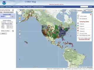
The Michigan Spatial Reference Network • 85 MSRN Stations
Monument Composition • All stations rigorously adhere to a 5 degree site clearance and have been positioned in locations free of excess multipath • Once the monument is in the ground and connectivity to the server is verified, then 30 days of data is collected and sent to the NGS for processing • The densification of this network and the implementation of its real-time capabilities have changed forever how GPS and Surveyors perform their tasks in the State of Michigan
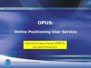
What is OPUS? • Online Positioning User Service • Free service by NGS for GPS users • Fast and easy to use • Requires minimum of 2 hours of data • Useful for checking
What it Provides • Provides location of receiver based on raw GPS data: • Geographic Coordinates (Latitude/Longitude) • State Plane Coordinates • UTM Coordinates • ITRF and NAD83 Coordinates • Ellipsoidal and Orthometric Elevation
What is OPUS-Rapid Static? • Same purpose as OPUS – provides location solution to GPS data sets • Key Advantage: Requires only 15 minutes of data • Accurate – 2 cm horizontal, 4 cm vertical • Brand New – January 31, 2007
What is OPUS-Rapid Static? • Uses new solution program – “Rapid Static GPS” (RSGPS) • RSGPS uses both P code and carrier phase (L1 & L2) range observations • LAMBDA (Least Squares Ambiguity Decorrelation Adjustment) algorithm to find ambiguity (N) • Ambiguity = difference in number of wavelengths between self-generated receiver phase and received GPS phase • D = c ΔT + λN; where c= speed of light, ΔT= time differenceand N = ambiguity in wavelength (λ)
What is OPUS-Rapid Static? • - Opus computes solution in reference to 3 CORS locations • - CORS sites selected by increasing distance from user's station and site stability. Search will stop if distance greater than 200 km. • - If search fails to locate 3 stations, program will refuse to attempt a solution • - Reference stations can be selected manually
How to use OPUS-Rapid Static • Service located at: http://www.ngs.noaa.gov/OPUS/ • Click OPUS Rapid Static link: • Required Data: • Email address for solution to be sent to • The GPS data file in RINEX format • Antenna Type, e.g. Leica ATX1230 • Antenna Height
How to use OPUS-Rapid Static • RINEX = standard GPS data set file format • Receiver Independent Exchange format • RINEX format converter at: http://facility.unavco.org/software/teqc/teqc.html • Or use Leica Geo-office
Results Wait 30 min. and NGS will send an email with the solution report.
Experimental Results OPUS Point Data in Static Mode OPUS Point Data in Rapid Static Mode Point ID Northing Easting Ortho Height Point ID Northing Easting Ortho Height Miller 242728.731 3909972.069 316.277 Miller 242728.713 3909972.070 315.337 Conestoga 243159.315 3909833.549 300.252 Conestoga 243159.308 3909833.567 300.286 297.849 2297.898 Heiss 243887.223 3909951.131 Heiss 243887.217 3909951.138 Difference in Static and R.S. Point ID Northing Easting Ortho Height Miller -0.018 0.001 - Conestoga -0.007 0.018 0.034 Heiss -0.006 0.007 0.049 • OPUS – RS results similar to standard OPUS results: • Greatest horizontal difference only < 2 cm; vertical difference significant for point Miller • Comparison not entirely valid
Conclusion • Michigan CORS is a revolutionary system that allows for high accuracy positional measurements • OPUS Rapid Static provide a free and convenient means of calculating GPS locations anywhere with one system. • It also provides easy and fast redundancy in GPS static measurements