Download
1 / 12
120 likes | 461 Views
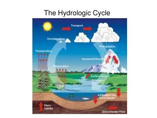
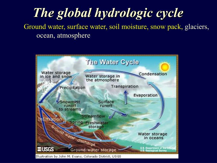
The global hydrologic cycle. Ground water, surface water, soil moisture, snow pack, glaciers, ocean, atmosphere . Grand Challenges in Hydrology. The terrestrial hydrologic cycle: Ground water, surface water, soil moisture, snow pack, glaciers (see Cryosphere)

E N D
The global hydrologic cycle Ground water, surface water, soil moisture, snow pack, glaciers,ocean, atmosphere
Grand Challenges in Hydrology The terrestrial hydrologic cycle: • Ground water, surface water, soil moisture, snow pack, glaciers (see Cryosphere) • What are the contributions of each land component to the global fresh water budget? • How do natural and anthropogenic processes redistribute water in both space and time? • How can we manage the water resources, mitigate associated hazards and integrate decision support? • How does the land surface vary with time and how does it influence the dynamic water supply?
Ground Water • Regional and continental scale aquifer characterization • Structural control - i.e. ground water barriers • Storage coefficients/parameters (flux and storage) • Subsidence mapping and hazard mitigation • Spatial, temporal, & magnitude control on land subsidence • Includes hydrocarbon and methane (CBM) • Earth fissuring - horizontal motion • Hydro-tectonics • Separating anthropogenic and tectonic subsidence sources • Aquifer poro-elastic response to earthquakes • Liquefaction • Groundwater management • Aquifer storage and recovery • Subsidence mitigation J. Hoffmann, 2003
Ground Water • Regional and continental scale aquifer characterization • ECHO – L-band InSAR mission with sub-monthly acquisitions • Access to current archives is required to establish long-term trends • C-band mission compatible with previous system • Subsidence mapping and hazard mitigation • ECHO – L-band InSAR mission with semi-monthly acquisitions • Multi look angles - 3D deformation field • Access to current archives is required to establish long-term trends • Hydro-tectonics • ECHO – L-band InSAR mission with semi-monthly acquisitions • Multi look angles - 3D deformation field • Access to current archives is required to establish long-term trends • Groundwater management • ECHO – L-band InSAR mission with sub-monthly acquisitions • Multi look angles - 3D deformation field • Access to current archives is required to establish long-term trends
Surface Water • Global time-series • Monitoring of vital spatial & temporal changes in surface water resources through aerial extent and volume measurements • Resolving velocity and circulation patterns in rivers and water bodies • Flood, Inundation, and Hazard Assessment • All weather tool for monitoring surface water extent during events • Spatial & temporal control on extent, water level, velocity patterns • Biogeochemical production in tropical areas • Inundated regions correlated with methane production • Natural and human oil spills - backscattering properties • Model and predict ice-debris accumulations, failure locations, and the resulting flood levels • Wetland • Water flow, engineering structures, water levels, restoration and management Wdowinski, et al, 2004
Surface Water • Global time series • L-Band mission with a minimum 14 day repeat time - daily acquisitions would be ideal. • Need near-nadir look angles to maximize water body backscattering • Along-track interferometry for velocity measurements • VV, HV,VH, HH polarization for vegetation • Access to current archives is required to establish long-term trends • Flood, Inundation, and Hazard Assessment • Multi-band mission desired, minimum L- Band mission with daily to sub-daily acquisitions • Need near-nadir look angles to maximize water body backscattering • Along-track interferometry for velocity measurements • VV, HV,VH, HH polarization for vegetation • Access to current archives is required to establish long-term trends • Wetland • L- and C- Band 5-day interferometric repeat time
Soil Moisture Soil moisture is an essential parameter in measuring the global water budget, climate modeling, and flood, landslide and debris flow forecasting. Detailed 4-D soil moisture maps • What is the state of the water (permafrost, frozen, liquid, etc)? • How do natural and anthropogenic processes impact the dynamic soil moisture supply? • What is the link between ecology, land-use, and soil moisture? • What is the depth distribution of soil moisture?
Soil Moisture Detailed 4-D soil moisture change maps • Multi-wavelength capability for varied penetration depths • Soil moisture as a function of depth • Minimum depth 10 cm and Maximum depth 1-2 meters • Full polarization desired • 10 meter postings desired • Temporal coverage • Ideal = daily • Minimum = weekly “This image shows what we believe is drying (blue) and moistening (yellow/red) between two SAR acquisitions in an arid region of Colorado. Pixel size is 50 m and image width is several kilometers.” Nolan, 2002
Snow Pack What is the extent and volume of water in snow pack? • Resolving the snow-water equivalence is essential for constraining the contribution of the snow pack on the global water budget and forecasting water supply. • How do snow pack properties vary spatially and temporally? • Need real-time data collection for flood prediction associated with snow melt. • Weekly coverage • Glacial mass balance (see Cryoshpere)
Snow Pack What is the extent and volume of water in snow pack? • Satellite requirements • L-Band minimum • Multi-wavelength acquisition preferred • Full polarimetry for snow structure is desirable • Weekly coverage Rott, et al, 2003
Land Surface Change How does the land surface vary with time and how does it influence the dynamic local-global water supply, especially when radar scatters are significantly altered? …. DEM subtraction • What is the source, path, deposition, and volume of material transported during large events? • The temporal and spatial SAR imaging will result in significant advances in the understanding of the mechanics, kinematics, monitoring, and prediction of mass movement. • Hazards include landslides, sink holes, mine collapse, floods • What is the volume of material lost in coastal erosion? • What is the relationship between hydrology and habitat in slope stability in post-fire environments? • How do hydrologic parameters vary with topographic change?
Land Surface Change How does the land surface vary with time and how does it influence the dynamic local-global water supply, especially when radar scatters are significantly altered? …. DEM subtraction InSAR requirements • Z (vertical) relative error of 1/2 meter desired • X,Y (horizontal) resolution at a minimum of 20 meters • Orbit/mission control optimized to potentially generate monthly DEMs Differential ERS generated DEMs mapped Net erosion and deposition caused by an Extreme glacier outburst flood in Iceland November 1996. Smith et al, 2000