Download
1 / 2
20 likes | 152 Views
Slightly offset position of the site leads to the incorrect watershed boundary. Correct position of the site on the stream results in the correct watershed boundary. &. Regional watersheds used in cutting grids (8 digit HUC). Standard watershed and stream delineation recipe. Site which is

E N D
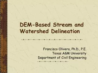
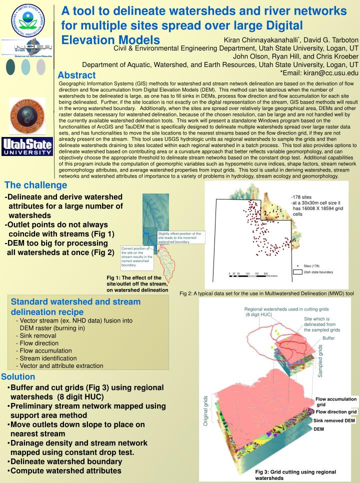
Slightly offset position of the site leads to the incorrect watershed boundary Correct position of the site on the stream results in the correct watershed boundary. & Regional watersheds used in cutting grids (8 digit HUC) Standard watershed and stream delineation recipe Site which is delineated from the sampled grids - Vector stream (ex. NHD data) fusion into DEM raster (burning in) - Sink removal - Flow direction - Flow accumulation - Stream identification - Vector and attribute extraction Buffer Sampled grids Flow accumulation grid Original grids Flow direction grid Sink removed DEM DEM Fig 3: Grid cutting using regional watersheds A tool to delineate watersheds and river networks for multiple sites spread over large Digital Elevation Models Kiran Chinnayakanahalli*, David G. Tarboton Civil & Environmental Engineering Department, Utah State University, Logan, UT John Olson, Ryan Hill, and Chris KroeberDepartment of Aquatic, Watershed, and Earth Resources, Utah State University, Logan, UT *Email: kiran@cc.usu.edu Abstract Geographic Information Systems (GIS) methods for watershed and stream network delineation are based on the derivation of flow direction and flow accumulation from Digital Elevation Models (DEM). This method can be laborious when the number of watersheds to be delineated is large, as one has to fill sinks in DEMs, process flow direction and flow accumulation for each site being delineated. Further, if the site location is not exactly on the digital representation of the stream, GIS based methods will result in the wrong watershed boundary. Additionally, when the sites are spread over relatively large geographical area, DEMs and other raster datasets necessary for watershed delineation, because of the chosen resolution, can be large and are not handled well by the currently available watershed delineation tools. This work will present a standalone Windows program based on the functionalities of ArcGIS and TauDEM that is specifically designed to delineate multiple watersheds spread over large raster data sets, and has functionalities to move the site locations to the nearest streams based on the flow direction grid, if they are not already present on the stream. This tool uses USGS hydrologic units as regional watersheds to sample the grids and then delineate watersheds draining to sites located within each regional watershed in a batch process. This tool also provides options to delineate watershed based on contributing area or a curvature approach that better reflects variable geomorphology, and can objectively choose the appropriate threshold to delineate stream networks based on the constant drop test. Additional capabilities of this program include the computation of geomorphic variables such as hypsometric curve indices, shape factors, stream network geomorphology attributes, and average watershed properties from input grids. This tool is useful in deriving watersheds, stream networks and watershed attributes of importance to a variety of problems in hydrology, stream ecology and geomorphology. The challenge -Delineate and derive watershed attributes for a large number of watersheds -Outlet points do not always coincide with streams (Fig 1) -DEM too big for processing all watersheds at once (Fig 2) -178 sites -at a 30x30m cell size it has 16008 X 18594 grid cells Fig 1: The effect of the site/outlet off the stream, on watershed delineation Fig 2: A typical data set for the use in Multiwatershed Delineation (MWD) tool Solution • Buffer and cut grids (Fig 3) using regional watersheds (8 digit HUC) • Preliminary stream network mapped using support area method • Move outlets down slope to place on nearest stream • Drainage density and stream network mapped using constant drop test. • Delineate watershed boundary • Compute watershed attributes
OUTPUT Files -Watershed boundary -Stream network Attributes -Watershed area -Elevation statistics -Hypsometric curve indices -Drainage density -Watershed shape factor Climate Watershed morphology Hydrologic indices Soils = f , , BFI DAYCV QMEAN Q1.67 ZERODAY Colwell’s index 7Qmin 7Qmax NOR Flood frequency Mean annual precipitation Monthly mean temperature Monthly max and min temperature • Watershed area • Main channel length • Main channel slope • Mean elevation • Relief • Drainage density • Basin shape • Hypsometric • curve indices • Outlet elevation • Soil thickness • Available water • capacity • Permeability • Bulk density Response variables Explanatory variables Computed using MWD program Derived using zonal statistics tool within MWD program Fig 6: Example of MWD tool use in deriving watershed attributes for building statistical models to estimate stream flow regime variables at ungauged sites INPUT Raster/grids -DEM -Sink removed DEM -Flow direction grid -Flow accumulation grid -Stream grid Shapefiles -Regional watersheds (polygons) -Sites or outlets (points) Fig 4: Multiwatershed delineation (MWD) program A standalone program that uses TauDem and ArcObjects functionalities with a visual basic interface • Other features • -Options for drainage delineation methods • a) Curvature based method • b) Support area method • -Constant drop test for objectively choosing the threshold for delineation • -Zonal statistics tool for sampling other raster datasets (climate, soil, geology etc) over multiple watersheds. Fig 5: Output from the Multiwatershed delineation program APPLICATION • We developed this program to allow us to efficiently derive physical properties for thousands of watersheds and sample sites. • This tool is used to derive watershed boundaries and attributes for sites in the Western United States for • -developing statistical models to estimate stream flow regime variables at ungauged basins by relating them to watershed attributes (Fig 6) • -for classifying streams and rivers using different classification schemes (ex. Geomorphologic, geologic, hydrologic etc)