Download
1 / 30
300 likes | 306 Views
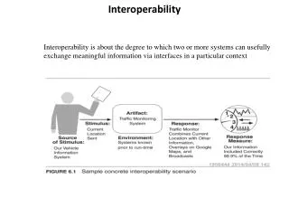
Advanced Data Interoperability: LiDAR, 3D, and BIM. Bruce Harold & Dale Lutz. ArcGIS Data Interoperability Extension. Convert and transform data in 100+ formats Graphical workflow authoring. LiDAR. Overview of point cloud scenarios. Converting point cloud formats.

E N D
Advanced Data Interoperability:LiDAR, 3D, and BIM Bruce Harold & Dale Lutz
ArcGIS Data Interoperability Extension • Convert and transform data in 100+ formats • Graphical workflow authoring
LiDAR Overview of point cloud scenarios
Converting point cloud formats Import point clouds and automatically generate .lasd for quick LAS use in ArcGIS.
Demo Convert TerraScan directory to LAS
Transforming point clouds • Thinning • Drape to create a surface model • Slicing/profiling to divide along a line • Update extents • Combine • Set components manually • Point-by-point calculations • Point-by-point filtering • …
Reprojection Change a point cloud’s coordinate system Support for geocentric coordinates and orthometric heights
Clipping Toss away points outside a defined area Cubic clipping: clip to a 3D solid Clip to just the area you need Data becomes more manageable to work with
Tiling Chop points into a series of tiles Speed up processing time using parallel processing on tiles Easier delivery for large point clouds
Splitting Extract points based on the value of any component E.g. color, classification, intensity Can split based on exact value or range
Demo Split a point cloud
Colorization Automatically set color components Overlay point cloud on raster
Demo Colorize point cloud with orthophoto
3D GIS Working with 3D data
Working with 3D data • Converting 2D building outlines to 3D • FeatureMerger joins outlines with tabular data containing building heights • Extruder adds 3rd dimension to create 3D solids • 3DForcer to set base heights for 3D • TINGenerator creates TIN from a point cloud • AppearanceSetter defines details of 3D surface
Demo Convert Shapefile to Sketchup Create surface model TIN using height information from a point cloud
BIM and GIS Working with BIM data
Working with BIM • File size and complexity make BIM data hard to repurpose • BIM exports IFC (too complex) or DWG (too simple) • Key: keep what you need, discard what you don’t
BIM to GIS: Mount Vernon • George Washington’s home laser scanned to create high quality BIM in Revit • Data Interoperability extension used to convert BIM to GIS • Export Revit data (plus added georeferencing) with FME Revit Exporter • Import to ArcGIS with Data Interoperability extension • Reconnect attribution • Browser delivery – easy sharing • Rich detail of BIM with spatial context of GIS
BIM to GIS Scenarios • Translate Revit floorplan to Geodatabase • Extract/use BIM georeferencing • Complete control over IFC hierarchies • Reduce BIM data volumes • Update BIM from Excel tables • Webinar: GIS and BIM Interoperability -fme.ly/gisbim
Minecraft Exporting to
Working with Minecraft • A Minecraft world is a point cloud • blockID and blockData components • Convert any data to Minecraft • Vector • Raster • LiDAR • BIM • etc.
Example Bowen Island: GIS + DEM to Minecraft
Workspace summary Read road lines (Shapefile), forest polygons (MapInfo), and raster DEM Buffer and clip vectors to avoid overlap Rasterize vector layers Make numeric rasters for Z, blockID, blockData Convert raster pixels to points Set Z value and point cloud components
Minecraft and the real world • Hypothetical scenarios • Lava flow • Forest fires • Rising sea levels • Geodesign • Sweden used Minecraft for public urban planning • Fun: fme.ly/MazeGenerator
Resources • Download a trial at esri.com/datainteroperability • Esri Virtual Campus – search “Spatial ETL” on training.esri.com • Transforming Data Using Extract, Transform, and Load Processes • Controlling Data Translations Using Extract, Transform, and Load Processes • Webinar: GIS and BIM Interoperability - fme.ly/gisbim • Webinar: LiDAR and ArcGIS - fme.ly/interoplidar • Tutorial: How to make Minecraft worlds in FME - fme.ly/minecraft
Thank you… • Please fill out the session survey in your mobile app • Select Data Interoperability Extension: Advanced Use • Use the Search Feature to quickly find this title • Click “Technical Workshop Survey” • Answer a few short questions and enter any comments