Download
1 / 30
300 likes | 303 Views
The Global Positioning System (GPS) has revolutionized navigation, making it easier to locate objects and people on Earth. This article explores the history of navigation tools, the challenges of determining longitude, and the role of time in solving the problem. Discover how GPS has transformed navigation and improved safety.

E N D
The Global Positioning System: Few changes of great importance to economics and safety have had more immediate impact and less fanfare than GPS. • GPS has quietly changed everything about how we locate objects and people on the Earth. • GPS is (almost) the final step toward solving one of the great questions of human history. Where the heck are we,anyway?
In the Beginning……. • To understand what GPS has meant to navigation it is necessary to go back to the beginning. • A quick look at a ‘precision’ map of the world in the 18th century tells one a lot about how accurate our navigation was. • People have been trying to measure latitude and longitude for a long time, with varying success.
Tools of the Trade: • Navigator’s early tools could only crudely estimate location. • Longitude could only be estimated by dead reckoning. • A Sextant can measure the elevation of something above the horizon (Polaris, the Sun...) This can be used to find Latitude. • Distance could sort of be measured, by counting steps (or wheel rotations) or estimating speed and time traveled • The Compass could provide you with a measurement of your direction
Dead Reckoning: • To determine one’s East-West position, the accepted method was called Dead Reckoning (perhaps aptly named). • Dead Reckoning has many sources of error that add up over a long journey. Even 95% accuracy in crossing from New York to London will accumulate to 175 MILES of error at the end of the trip. • These kinds of error were a Seriousproblem for ships approaching rocky coasts or areas with submerged shoals and seamounts!
Plenty of Weaknesses: The early tools had many levels of uncertainty that were cumulative in producing poor maps of the world. • Step or wheel rotation counting has an obvious built-in uncertainty. • The compass relies on the assumption that the North Magnetic pole is coincident with North Rotational pole (it’s not!) and that it is a perfect dipole (nope…). Navigation on land was helped by the availability of landmarks, places that could put context to a map and help calibrate a journey. Such a technique is worthless at Sea….
Will Eventually Turn into THIS! This Navigation at Sea: Without any question THE most important maritime dilemma of the Renaissance world was how to determine Longitude. • A sextant can be used to give latitude very effectively at sea. • A compass can give you a good idea of your direction. • But unless you can determine how far East/West you’ve gone….
Longitude! On October 22, 1707, a dead reckoning error by the fleet of Admiral Sir Clowdisley Shovel led to the death of 2000 sailors. • In 1717, Queen Anne authorized a prize of 20,000 £ to anyone who could maintain knowledge of longitude to ½ degree (the equivalent of 30 miles on the equator). • Almost all of the methods proposed for solving this problem centered on the 4th element of navigation we haven’t talked about much…….TIME. Why is Time so important?
Meridians and Longitude: • Your Meridian is nothing more than a circle on the Earth that goes through the North and South Poles and your position. • The Prime Meridian is the meridian that goes through an agreed upon zero point. • The Prime is located today in Greenwich, England. • The angle going west from Greenwich to your meridian is your LONGITUDE!
Longitude and Time: So how do longitude and time relate? • It turns out that while there may be no landmarks on the ocean, there are fixed reference points…the stars. • As the Earth turns, the stars pass by overhead. Each star crosses every meridian on Earth exactly once each day. • So the difference between the time a star crosses the prime and your meridian is your longitude. • The problem then comes down to knowing what time it is at the prime meridian…exactly. • Every 4 minutes of error equals 1 degree or 60 miles on the equator.
Telling Time: To win the longitude prize one had to be able to maintain accurate time to within 2 minutes over a several months at sea. People found several ways to do this. • Galileo couldn’t win the prize (he was dead), but he had devised a way of determining the time using the moons of Jupiter. Galileo’s Notebook Galileo Galilei, 1564-1642
Telling Time With The Moons of Jupiter • The four readily visible (Galilean) moons of Jupiter have a (complex) predictable cycle which can be used to tell time • This actually worked well, but only for that part of the year when Jupiter was visible at night!
The Lunar Method: • The astronomers Tobias Mayer and Nevil Maskelyne proposed using the predictable changes in the distance to the moon. • This also worked, but was VERY hard to do correctly and didn’t work when the moon was less than ½ full. • “They had all used the procedure, many times, they said, just as it was outlined by Maskelyne in The British Mariner’s Guide, and they always managed to compute their longitude in a matter of a mere four hours.”
John Harrison’s Clock: • John Harrison went after the prize by building accurate clocks that could survive the weather extremes and motion of ship travel.
John Harrison’s Clocks: • Between 1736 and 1764 John Harrison produced 4 clocks for the Board of Longitude (the group that held the prize). • Each clock was smaller and more accurate than the previous one. And they ALL met the condition for the longitude prize. None were accepted! • So why were they locked in an observatory instead of saving lives on ships during this time? • Because Nevil Maskelyne was chair of the Board of Longitude… • It would take an act of King George III to break the logjam and put chronometers into wide use.
The (FIRST) Global Positioning System: Harrison’s clock changed navigation in a fundamental way. • Anyone with a sextant and a chronometer could find their position to within a few miles on the Earth. They weren’t perfect though • The clocks were incredibly expensive and in fairly short supply. • Since they relied on Greenwich time, they had to be re-calibrated to Greenwich: Usually in Greenwich. • Positions could only be determined at sunrise or sunset when both a star and the horizon could be seen. • It didn’t work at all if the weather was cloudy…..
A Modern Solution: Harrison’s clock (and its successors) made navigation possible for commercial shipping and the well to do, but it wasn’t for the masses. • A universal navigation system would need the following. • A way to tell time that isn’t expensive. • A clock that can be calibrated anywhere, not just in Greenwich. • A set of references that didn’t disappear whenever it was cloudy Enter the MODERN Global Positioning System (GPS):
The Global Positioning System: For all its complexity, GPS still comes down to the same set of requirements that Harrison faced. • Find out the time. • Find the reference points. • Use the output to determine Longitude and Latitude to high precision. GPS adds a pair of twists: • The reference points also serve as the clock. • Everyone uses the same system. The GPS network is effectively a single device, like Harrison’s clock.
GPS satellites. • GPS ground support. • GPS receivers. Parts of the GPS Network: The GPS system consists of 3 elements.
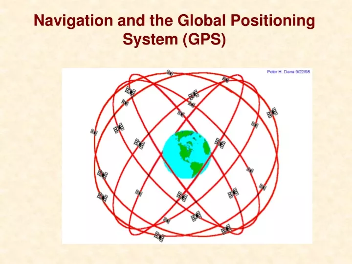
There are 6 orbit ‘planes’ inclined by 55° to the equator and rotated for a 60° spacing between them. The GPS Satellite System: The first GPS Satellite was launched in 1978. • To function properly the network of satellites must contain 24 units. With GPS it is all about coverage. • Each satellite has a 12 hour orbit, which means it passes over the same place twice each day. • Each plane contains 4 satellites.
A Ground Track map shows how this scheme covers the Earth. The GPS Satellite System: The first GPS Satellite was launched in 1978.
The GPS Ground Support: The GPS satellites are nothing more than atomic clocks that work because we know where and when they can be found. • To maintain the satellites requires a ground support network (called the control segment - CS) that uplink time and radar tracking position data to the satellites (called the space vehicles – SV). • There are 5 CS components that update satellites and also communicate data to some advanced GPS reveivers
The GPS Receiver: The receiver units are the backbone of the mass market GPS. The receivers serve 3 purposes. • Small handheld units receive signals from 4 or more SVs. The receivers are called the User Segment -US. Decoded signals provide X, Y, Z, and T. Everyone can find out where they are. • Via SV-US communication, the exact time can be synchronized worldwide in a matter of a few seconds. • By combining signals from nearby receivers, very accurate navigation and surveying data can be obtained.
The Method of GPS: • How does GPS work?. • Your GPS receiver gets signals from satellites that are doing nothing more than repeating the time over and over. • Since light travels at a finite speed, there will be a difference between the instantaneous time on your receiver and the time you get from the satellite. Time Difference = (Speed of Light) x (Distance) • The time differences are small. 1000 feet of distance translates to only a 1,000,000th of a second! • The satellites know exactly where they are in X, Y, Z. So, if you have a bearing to three of them, then you know as well.
But wait! • There’s a caveat to this. YOU don’t carry an atomic clock. They are expensive and heavy. YOUR receiver clock is going to be off a some random amount when it compares time with the satellites. How do we get around this?
An atomic clock in your pocket We add a 4th measurement! • If we knew the time, a 4th satellite would be redundant. • However, the extra satellite can ONLY match up with the other three at the CORRECT time. It removes the error and calibrates your receiver at the same time!!! • This technique lets your GPS unit know the time to within ~100 ns (0.0000001 seconds).
GPS is amazing • ESS205 flights use the postage-stamp sized Trimble Lassen-SQ GPS • How much for this incredibly advanced technology? $50!