Download
1 / 55
820 likes | 1.71k Views
GPS Global Positioning System. Dr. Volkan Nalbantoğlu AE 484 Inertial Navigation Systems May 2008. Contents. Radio Navigation GPS History Parts of GPS GPS Signals How Does GPS Work? GPS Error Sources. Ra dio Navigation Systems.

E N D
GPSGlobal Positioning System Dr. Volkan Nalbantoğlu AE 484 Inertial Navigation Systems May 2008
Contents • Radio Navigation • GPS History • Parts of GPS • GPS Signals • How Does GPS Work? • GPS Error Sources
Radio Navigation Systems • Radio navigation consists of finding position and heading by using electromagnetic wave propogation. • Examples: • Radar • VHF Omnidirectional Range (VOR, VOR/DME) • Long Range Navigation (LORAN-C) • Global Positioning System (GPS)
What is GPS ? • GPS is a satellite based navigation system. • It is developed and financed by the U.S. Department of Defense. • It provides position velocity and timing information anywhere in the world under any weather condition.
Initially it was developed as a military system (1970s) • In 1980s it became available for civilian use. • Today it is being used in land, air and marine applications by millions of people.
GPS History • First radio navigation research started in 1920s • During the 2nd World War LORAN became operational and it was possible to find latitude and longitude by using the time of arrival information of the radio signals sent from ground stations.
GPS History • During 1959-1964: USA developed the TRANSIT satellite system to determine the location of nuclear submarines. • 7 low orbit sattelites • Latitude-Longitude information • Long measurement time • Only for slow dynamic vehicles
GPS History • 1978-1985 • Total of 11 block I Satellites sent • 1989 first block II Satellite sent
Current Configuration • Nominally there are 24 satellites (4 on 6 orbital planes) • Currently there are 29 operational Block II/IIA/IIR/IIR-M satellites
GPS Segments • There are 3 segments • Space • Control • User
GPS Space Segment • Consitsts of the space vehicles (satellites) and the radio signals sent by these satellites. • GPS satellites • Height ~20200 km • 6 orbits with at least 4 satellites on each orbit • Period ~ 1 revolution / 12 hour • Weight ~950 kg • Size 1,6 x 6 m
Block II/IIA Block IIR ve IIR-M GPS Space Segment • At least 5 satellites are visible from anywhere on the earth • There are solar panels and 12 navigation antennas on each satellite.
GPS Control Segment • Monitors and Controls the GPS satellites. • One Master Control Station (MCS),Five Monitor Stations (MS)
GPS Control Segment • Functions of the Control Segment • Detection and determination of Satellite orbits • Correction of satellite clocks • Updating the satellite messages • Monitoring the status of each satellite and performing the maintanence tasks
GPS User Segment • Consists of receivers that can decode the satellite signals • GPS receivers transform the satellite signals into position, velocity and time information.
GPS Services • GPS has two levels of information • Precise Positioning Service - PPS • Standard Positioning Service - SPS
GPS Services – PPS • Precise Positioning Service (PPS) • Can be used by authorized users only • Planned for military purposes
GPS Services – PPS • Access to PPS is controlled by two methods • SA (Selective Availability), GPS accuracy is degraded intentionally by adding pseudo-random errors on the signals. • A-S (Anti-Spoofing), Encrypted code
GPS Services – PPS • 16 m SEP (3D - %50) Position accuracy • 100 ns (1 σ) timing accuracy
GPS Services – SPS • Standard Positioning Service (SPS) • Open to all users but less accurate • With Selective Availability • 100 m SEP (3D - %50) position accuracy • 337 ns (1 σ) time accuracy
GPS Services – SPS • SA has been removed on May 2000 • SPS users have accuracies close to PPS
GPS Signals • GPS satellites send very weak radio signals on two L – band frequencies (L1 and L2) • L1 and L2 are carrier frequencies. These are sinusoidal signals
GPS Signals • All GPS satellites use the same frequency carriers (L1 and L2) • But each satellite has its own identification code • These are two types of codes modulating the L1 and L2 carriers. • C/A – Code • P – Code
L2 L1 C/A P(Y) P(Y) GPS Signals • L1: 1575.42 MHz • Modulated byC/A-code & P-code • Signal Power: -160 dBW • L2: 1227.6 MHz • Modulated by P-code only • Signal Power : -166 dBW 1575 MHz 1227 MHz
GPS Signals Carriers (L1/L2) Bipolar Phase Shift Keying (BPSK) Modulation C/A - Code (L1) P - Code (L1/L2) Nav Data (L1/L2) A-S Encryption P – P(Y) Phase Quadrature O SA Degredation
GPS Signals • GPS receivers generate the equivalent of these codes internally and compares with the ones coming from the satellites. • GPS receiver shifts the internally generated code until it matches with the received one (cross-correlation)
GPS Signals • Another Message on the L1 ve L2 carrier frequency is the “Navigation Message” • Navigation Message • 50 Hz Clock rate • Has information specific for each satellite • Has the satellite position and time delay information
GPS Signals • 50 Hz • 6 s for one subframe • 30 s for one frame • 12,5 min for the whole set
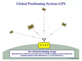
How Does GPS Work? • Based on a geometric principle “Position of a point can be calculated if the distances between this point and three objects with known positions can be measured ”
How Does GPS Work? • If the distance to one object is known: • Then I am on a sphere with the object at the center
How Does GPS Work? • If I know the distance to a second object: • Then I am on a circle which is the intersection of two spheres
How Does GPS Work? • If I know the distance to a thrid object: • Then I am on one of the two points which are at the intersection of three spheres
How Does GPS Work? • To find the distance to a satellite “Signal Time of Transmission” is used • How is Signal Time of Transmission calculated?
Satellite Receiver How Does GPS Work? • GPS receiver generates the same signal that is coming from the satellite (C/A - Code) starting at the same time. • But the code coming from the satellite is delayed because it travels the distance between the satellite and the receiver.
T How Does GPS Work? • GPS receiver shifts the internally generated code until it matches with the received one and finds ΔT, Signal Time of Transmission Code generatede by the receiver Code generatede by the sattelite
How Does GPS Work? • Signal Time of Transmission is actually an indication of the distance between the receiver and the satellite • Signal travels with the speed of light and in Δt time travels a distance of Pr= C. ΔT (C = Speed of light)
How Does GPS Work? • Pr is the “Pseudo-Range” • It is called Pseudo-Range because it is not the real range between the receiver and the satellite due to uncertainties such as: • Synchronisation error between the receiver and satellite clocks • Change in the medium in which the signal travels
How Does GPS Work? • The dominant source of error in Pseudo-Range calculation is the synchronisation between the receiver and the satellite • Satellites have very accurate and very expensive atomic clocks • It is not practical to use atomic clocks in the receivers. Standard crystal oscillators are used instead
How Does GPS Work? • This syncrhronisation error is called Clock Bias • To eliminate clock bias a forth satellite is used • 4 unknowns (3 dimensional position + Clock Bias) • 4 equations
How Does GPS Work? Pi =Pseudo-Range to satellites Xi , Yi , Zi = 3 Dimensional satellite cartesian coordinates X , Y , Z= 3 Dimensional satellite cartesian coordinates b = Receiver clock bias (in terms of distance)
How Does GPS Work? • These 4 non-linear equations are solved and receiver coordinates and clock bisa are obtained • These equations are in ECEF (Cartesian) Coordinates • Latitiude, Longitude and hight values can be obtained by a transformation
How Does GPS Work? ECEF and Latitude / Longitude LOCAL Meridian Z User position GREENWICH Meridian h Pz R Y O Px Px: ECEF Pos x (M) Py: ECEF Pos y (M) Pz: ECEF Pos z (M) Py X Equator
GPS Error Sources • SA (Selective Availability) • Satellite clock errors • Satellite orbit errors • Atmospheric effects • Receiver noise • Multipath • Number of satellites in range • Satellite geometric configuration
GPS Error Sources • DOP (Dilution of Precision) • GDOP - Geometric DOP • It is a metric to define the effect of the satellite geometry on the accuracy of the solution: • PDOP – Position DOP (3 D Position) • HDOP – Horizontal DOP (Horizontal position) • TDOP – Time DOP (Time)
GPS Error Sources • Satellites close to each other have larger uncertainty
Satellites far away from each other have less uncertainty GPS Error Sources
GPS Error Sources • 1 signifies the ideal situation • Satellites grouped on the same side cause larger DOP – Bad accuracy • Well distributed, smaller DOP – better accuracy