Download

1 / 11
130 likes | 399 Views
SPATIAL ANALYSIS OF WATER QUALITY PARAMETERS ALONG THE PERIPHERAL RIVERS OF DHAKA , BANGLADESH. PRESENTED BY Sayma Rahman. 5 DECEMBER, 2005 CLASS PROJECT GEOG 4510: Theory of GIS: Part I Tennessee Tech University. 1998. Figure: GW Depletion at different locations of Dhaka City. 2005.

E N D
SPATIAL ANALYSIS OF WATER QUALITY PARAMETERS ALONG THE PERIPHERAL RIVERS OF DHAKA , BANGLADESH PRESENTED BY Sayma Rahman 5 DECEMBER, 2005 CLASS PROJECT GEOG 4510: Theory of GIS: Part I Tennessee Tech University
1998 Figure: GW Depletion at different locations of Dhaka City 2005 Water Demand (ml/d) Population 2025 2020 2015 2010 2005 2000 Fig:Population and Water Supply Demand Projection INTRODUCTION – Problem Statement • Dhaka’s water supply: GW (Ground Water) sources 82% SW (Surface Water) sources 18% • GW resource rapidly declining. • Additional 42% demand projected in next 20 years • Surface water highly polluted. • Spatial assessment of surface WQ needed to relocate water intake point for optimal conjunctive use.
OBJECTIVES • Spatially demonstrate the existing level of WQ parameters along the rivers of Dhaka. • Qualitatively identify the optimal relocated intake point. • Develop geographic information base on river WQ for environmental modeling and planning. METHODOLOGY • Develop a GIS based map of the study area showing water quality sampling points 2. Present spatial information on current WQ 3. Compare water quality parameters with Bangladesh Standards for surface water. 4.Identify qualitatively a suitable location for abstraction of surface water using GIS.
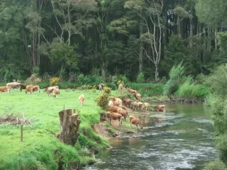
STUDY AREA • Main rivers around Dhaka • Sampling Routes : i. Tongi canal-Balu river • ii. Tongi canal-Turag river- • Buriganga- Dhaleshwari • iii. Shitalakhya river Dhaka City COLLECTED DATA • GPS data of the sampling locations • WQ parameters: • DO NH3 – N • BOD NO3-N • COD PO4 Study area Peripheral Rivers of Dhaka City
RESULT and ANALYSIS Dhaka City
RESULT & ANALYSIS ( contd….) DO BOD COD Upstream Lakhya Ideal for Relocation of Intake Point PO4-P NH3-N NO3-N
CONCLUSION • The peripheral rivers currently not suitable as a reliable source for water supply for Dhaka City in the dry season. • GIS analysis identified an optimal relocated point for future water intake • A suggested approach: Use River water during the rainy monsoon season (when the water quality is good due to dilution effects) and ground water during dry (winter) months. • Using GIS, the work laid the foundations for city planners and designers to: • Choose a proper water quality model • Formulate strategies for water abstraction and water supply for a growing city.
ACKNOWLEDGEMENT Data: Institute of Water Modeling, Water Resources Planning Division , Dhaka, Bangladesh. THANK YOU