Download
1 / 51
510 likes | 653 Views
Enhancing the Advanced Hydrologic Prediction Service: A Program to Develop A Low-Flow/Stage Database for Selected NWS Forecast Points in the Upper Colorado River Basin August 18, 2009 – Boulder, CO Mark Svoboda, Climatologist, Monitoring Program Area Leader, NDMC

E N D
Enhancing the Advanced Hydrologic Prediction Service: A Program to Develop A Low-Flow/Stage Database for Selected NWS Forecast Points in the Upper Colorado River Basin August 18, 2009 – Boulder, CO Mark Svoboda, Climatologist, Monitoring Program Area Leader, NDMC Dr. Donna L. Woudenberg, Drought Management Specialist, NDMC Dr. Cody L. Knutson, Water Resources Scientist, NDMC Doug Kluck, NOAA-NWS CRHQ
Outline • Context • High-flows vs. Low-flows • Completed Low-flow Projects • Upper Colorado River Basin Project • A real-time tool: The DIR • Wrap-up: What can it mean to SWSI?
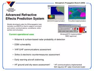
Advanced Hydrologic Prediction Service • Flood early • warning system • Network of >4300 • stream gauges • Providing current • river flow/stage data • Up to 7-day • forecasts at many • forecast points • 90-day probabilistic • forecasts at about 1/3 • of the forecast points http://www.weather.gov/ahps/
AHPS Flood Classifications Minor Flooding: minimal or no property damage, but possibly some public threat or inconvenience. Moderate Flooding: some inundation of structures and roads near stream. Some evacuations of people and/or property to higher elevation is necessary. Major Flooding: extensive inundation of structures and roads. Significant evacuations of people and/or transfer of property to higher elevations.
River Stage and Flood Impact Information Gunnison River at Grand Junction (Photo taken by Ken Dewey, 2001)
Cumulative Chance of Exceeding Levels (90 day outlook) The values along the x axis show the probability of reaching a particular flow (y axis). CS = conditional simulation; HS = historical simulation
Although providing great benefits for flood protection, the AHPS system does not provide the same information for low flow events. Low flows in rivers and streams can have similar harmful effects in terms of health, economic, and environmental consequences.
Low-flow / Drought Impacts • Economic • Costs and losses to agricultural and livestock producers • Loss from timber production • Loss from fishery production • Loss to recreation and tourism industry • Energy-related effects • Water Suppliers • Transportation Industry / navigation • Decline in food production/disrupted food supply • Environmental • Damage to animal species • Hydrological effects • Damage to plant communities • Increased number and severity of fires • Wind and water erosion of soils, reduced soil quality • Air quality effects (e.g., dust, pollutants) • Visual and landscape quality (e.g., dust, vegetative cover, etc.)
Low-flow / Drought Impacts • Social • Health • Increased conflicts (“water wars”) • Reduced quality of life, changes in lifestyle • Disruption of cultural belief systems (e.g., religious and scientific views of natural hazards) • Reevaluation of social values (e.g., priorities, needs, rights) • Public dissatisfaction with government drought response • Perceptions of inequity in relief, possibly related to socioeconomic status, ethnicity, age, gender, seniority • Loss of cultural sites • Increased data/information needs, coordination of dissemination activities • Recognition of institutional restraints on water use
Led to the development of a low flow/stage impacts database for AHPS forecast points Objective 1: Identify low flow/stage related impacts near NWS forecast points Objective 2: Use impact information to establish low flow/stage warning triggers (drought stages) Objective 3: Develop low flow/stage river forecasts Incorporate data into the NWS National Hydrologic Database and the AHPS system
Completed Low Flow Projects • Upper Mississippi River Basin (2004) • MN – 21 forecast points • North Platte River Basin (2005) • CO, WY, and NE – 17 forecast points • Upper Missouri Basin (2006) • WY, MT, and ND – 45 forecast points • Upper Trinity River Basin (2007) • TX – 29 forecast points • Red River of the North (2007) • ND & MN – 35 forecast points • Conducted internet and literature reviews • Collected information on potential low flow impacts from federal, state, and local water experts
Experts Were Asked to Provide Information on: • The impacts of low river levels • The stage/flow at which impacts occur • Which AHPS site(s) best reflect the impacts • Other factors that affect particular impacts/locations • Key Findings • loss of municipal, industrial, and agricultural water • activation of water rights regulation procedures • activation of state and local drought response plans • reduced recreational opportunities • hydropower losses • dredging to maintain navigation • fish and wildlife losses • exposure of infrastructure • increased effluent testing (NPDES)
Conclusion of Case Studies… Developing a better understanding of low river impacts at the local level will provide the benefit of more detailed information for water resources planning applications at all levels, as well as in advancing the development of the AHPS system.
2008-2009 Low-flow ProjectsUpper Colorado (164) & ACT-ACF (58)
NIDIS Pilot Programs • Upper Colorado River Basin • 164 stations – Central Region NWS/NIDIS • ACT-ACF • 50 + 8 stations – Southern Region NWS/NIDIS
2008-2009 Upper Colorado River Low-Flow Project Identify potential low flow/stage impacts near 164 forecast points
Upper CO 164 Stations • Progress made with 2/3; need information for remaining third • Examples of impacts received/recorded in following slides
Low-Flow Related Impacts in the Upper Colorado River Basin National Weather Service / National Drought Mitigation Center Station ID: 14 – SLRW4 (Smiths Fork at Stateline Reservoir, WY)
Low-Flow Related Impacts in the Upper Colorado River Basin National Weather Service / National Drought Mitigation Center Station ID: 29 – JESU1 (Green River near Jensen, UT)
Low-Flow Related Impacts in the Upper Colorado River Basin National Weather Service / National Drought Mitigation Center Station ID: 35 – STIU1 (Strawberry River at Strawberry Reservoir, UT)
Low-Flow Related Impacts in the Upper Colorado River Basin National Weather Service / National Drought Mitigation Center Station ID: 99 – WFDC2 (Williams Fork at Williams Fork Reservoir near Parshall, CO)
Low-Flow Related Impacts in the Upper Colorado River Basin National Weather Service / National Drought Mitigation Center Station ID: 106 – KRMC2 (Colorado River near Kremmling, CO)
Low-Flow Related Impacts in the Upper Colorado River Basin National Weather Service / National Drought Mitigation Center Station ID: 141 – GEPC2 (Gunnison River below Gunnison Tunnel, CO)
Potential Contacts • NDMC staff contact various water experts in the region, such as: • National Weather Service • United States Geological Survey • US Army Corp of Engineers • US Bureau of Reclamation • Natural Resources Conservation Service • State and Regional Water Agencies and Organizations • Soil and Water Conservation Districts • Community water managers near AHPS points • They help identify potential low-flow related impacts that can be linked to river flow/stages at NWS AHPS forecast points.
A Colorado Example 1) What effects would typically occur as the White River flow decreases at the AHPS forecast point near Meeker (WRMC2; #31)? 2) At what general stage/flow would those impacts occur? 3) Are these impacts seasonal? Or specifically drought-related?
Current White River AHPS Forecast Point at Meeker, Colorado What would happen as stage/flow decreases?
Future Work for River Forecast Centers… North Central River Forecast Center An example of a seven-day river forecast hydrograph with indicators of critical low flow and flood levels. The red line indicates the flood level. The tan line indicates the critical low flow level at this forecast point. The blue line shows the current river level and the green line is the actual forecast.
North Central River Forecast Center An example of a 90-day streamflow outlook for low water. The values along the x axis show the probability of reaching a particular flow (y axis). The brown zone at the bottom of the graph shows the critical level for this forecast point at which low water impacts begin to take effect. CS = conditional simulation; HS = historical simulation.
Why Record Drought’s Impacts? NDMC mission in a nutshell: To reduce vulnerability to drought… • Impacts point to vulnerability • Mitigation and response
Drought Impact Reporter (DIR) • On-line since July 2005 • >10,000 impacts logged, 2006-2009 • First searchable, multi-source, archived database of drought impacts in the U.S. • Combines data from multiple sources into a unified map • Media, public, government documents, etc.
Media 89% Other 1.2% NOAA 1% Gov’t 4.6% Public 4.2% Who Can Submit a Report? • Anyone interested in reporting the impacts of drought We need to increase non-media reporting! You can become a “drought spotter”
DIR 2.0 Enhancements • More user-friendly design • More efficient use of screen space • Improved searching and mapping • Change in category names • Distinguishes between reports and impacts • New “submit a report” form (w/ photo upload) • Ability to “tap” existing networks for drought information (ex. CoCoRaHS) • Coming Soon! (4Q 2009)
Networks to Add • CoCoRaHS • NWS Drought Reports • State reports: water restrictions, burn bans • Cropwatchers (Farm Bureau) • Extension Agents • Researchers
Summary • The Upper Colorado Low-flow Project will prove to be beneficial to managers, planners, and decision-makers in a number of ways, including: • by providing more detailed information for water resources planning applications at all levels • by enhancing the existing AHPS • Potential for low flow forecasts • Impacts as ground truth for indices (reality check) • by providing a high quality baseline document for the NIDIS Pilot Project in the region
Thank you! We welcome your participation and input as we work to improve the Drought Impact Reporter and other tools at the NDMC. Please contact me: Mark Svoboda msvoboda2@unl.edu 402-472-8238 http://drought.unl.edu http://droughtreporter.unl.edu